
Level-2 News
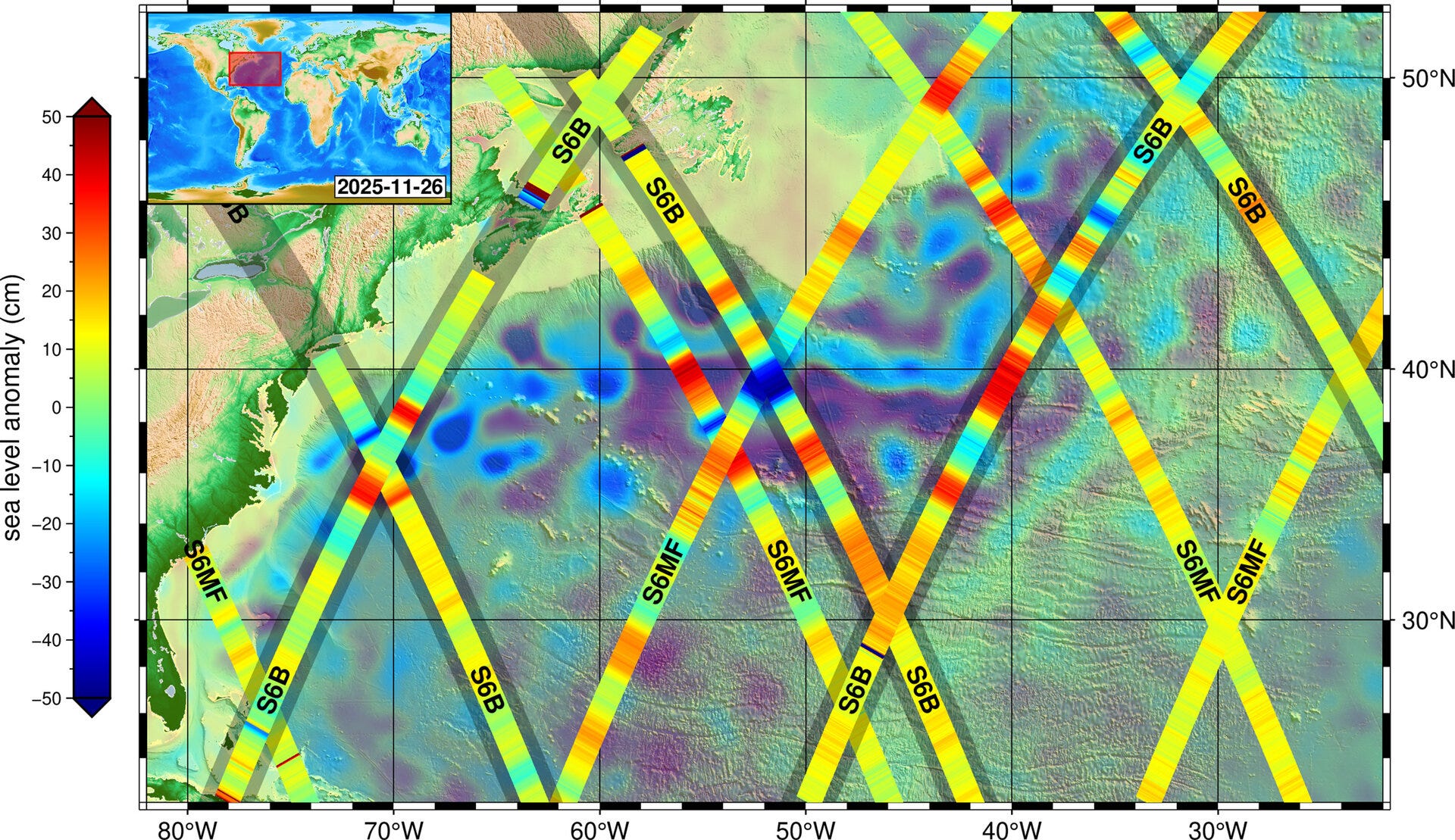
First image from Sentinel-6B extends sea-level legacy [link]
"Copernicus Sentinel-6B, launched last month, has reached its orbit and delivered its first set of data, which show variations in sea level in the North Atlantic Ocean. This data underlines how the mission will continue to strengthen the long-term reference record of sea levels, a key parameter of climate change."
Planet Reports Financial Results for Third Quarter of Fiscal Year 2026 [link]
Planet reported a record Q3 FY2026, with revenue reaching $81M (+33% YoY) and strong growth in RPOs ($672M) and backlog ($734M). The quarter was also marked by major defence wins, continued Pelican and SuperDove launches, and the acquisition of Bedrock Research to accelerate AI-driven global monitoring capabilities.
Other Planet News:
Planet Releases First Light Image From Pelican-6 [link]
Why Planet Labs (PL) Is Up 42.8% After Strong Q3 Results And Raised 2026 Revenue Outlook [link]
Finland’s ICEYE Closes €150 Million Series E Funding Round [link]
ICEYE has raised €150 million in Series E funding, led by General Catalyst, to expand its SAR constellation and accelerate Gen4 satellites with up to 16 cm resolution.
Kongsberg and Helsing to Develop Large Defence Satellite Constellation [link]
Helsing and Kongsberg have announced a German–Norwegian partnership to build a large LEO constellation for space-based intelligence, surveillance, and targeting, combining small satellites with AI-driven multi-sensor fusion. The project reflects Europe’s growing push for sovereign defence space capabilities, with initial deployments expected from 2028.
Kuva Space Links Up with WWF-Indonesia on Carbon Monitoring [link]
Indonesia will use satellite data and AI to monitor and quantify its blue carbon assets through a new partnership between Kuva Space and WWF-Indonesia. The collaboration will map mangrove and seagrass ecosystems using hyperspectral imagery, supporting scalable blue carbon accounting, conservation planning, and sustainable finance.
Umbra and Italy’s E-GEOS to Co-Develop Geospatial Intelligence Solutions [link]
Umbra and e-GEOS have signed a multi-year agreement to co-develop SAR-based geospatial intelligence solutions, combining COSMO-SkyMed data with Umbra’s commercial constellation.
Space Force Awards Muon Space $44.6M in SBIR Funding for 3-Satellite Mission [link]
The U.S. Space Force has awarded Muon Space $44.6M to deploy a three-satellite mission demonstrating a dual-use space-based environmental monitoring capability. The mission builds on Muon’s FireSat heritage, combining weather, cloud characterization, and wildfire monitoring with enhanced multispectral IR sensing and onboard processing.

SatVu releases first-of-its-kind thermal image revealing true operational activity inside major U.S. data centre [link]
SatVu has released a 3.5 m-resolution thermal image offering rare, near-real-time insight into operational activity inside a major U.S. data centre, revealing heat signatures from cooling, power, and high-load infrastructure. The release highlights how space-based thermal intelligence can bring independent transparency to the rapid expansion and energy footprint of global digital infrastructure.
Accelerating the Earth Index Flywheel with Support from the Patrick J. McGovern Foundation [link]
Earth Genome has secured a $600K grant from the Patrick J. McGovern Foundation to accelerate development of its Earth Index AI platform, supporting accountable supply chains, biodiversity monitoring, and sustainable food systems. The funding will drive new partnerships and technical enhancements aimed at delivering scalable, data-driven environmental impact.
OpenET Expands Satellite-based Water Use Data Across 48 States, Providing Critical Information to Farmers and Water Managers Across the Nation [link]
OpenET has expanded its free, satellite-based evapotranspiration data to cover all 48 contiguous U.S. states, providing farmers and water managers with high-resolution, daily and monthly insights to support more informed water management decisions.
EU Soil Monitoring Law Enters into Force [link]
The EU Soil Monitoring Law has entered into force, establishing a common framework to track and assess soil health across Europe amid growing evidence of widespread soil degradation. The law strengthens the role of data, remote sensing, and Copernicus indicators as foundations for protecting ecosystems, food security, and climate resilience.
ESA Phi-Lab UK funding awarded to address sustainable agriculture and space environmental challenges with AI [link]
ESA Phi-Lab UK has awarded ~£380k in seed funding to Deep Planet and Space DOTS, supporting AI-driven projects in soil carbon monitoring for sustainable agriculture and space environment intelligence as part of its first cohort.
Developer's Orbit
Wherobots introduces RasterFlow for scalable imagery preparation and inference [link]
Wherobots has launched RasterFlow, an on-demand workflow for preparing satellite imagery, running large-scale AI inference, and delivering analysis-ready outputs without users having to build custom infrastructure. In practice, it reduces the engineering effort needed to mosaic imagery, handle clouds, and operationalise geospatial models at scale, with results written directly to modern analytics-friendly data formats.
Wherobots is currently inviting users to request access via a private preview.
Rasterio 1.4.4 is out! [link]
Rasterio 1.4.4 introduces key maintenance upgrades, raising minimum requirements to Python 3.10+ and GDAL 3.6+, alongside enhanced reprojection controls and a broad set of bug.
Kudos to Sean Gillies and Alan D. Snow for their continued stewardship of one of the geospatial ecosystem’s core libraries.
STAC Browser v4.0.0 is out! [link]
STAC Browser v4.0.0 lands with a major upgrade, introducing an OpenLayers-based map engine, a refreshed UI, map-based collection search, and native GeoJSON visualisation.

Utilizing GDAL + STAC to Create Cloudless Sentinel-2 Composite [link]
Space4Good shared a walkthrough of building cloudless Sentinel-2 composites using STAC for data access and GDAL for processing, powered by the new GDAL 3.12 raster pipeline. The workflow combines mosaicking, reprojection, cloud masking, and median compositing into a fast, reproducible open-source pipeline, producing clean multispectral composites for downstream analysis.
Credit to Ramadhan for the work and results shared.
I/O-Maxing Tensors in the Cloud [link]
"Zarr Python (using either Icechunk or Obstore as the storage engine) is now able to fully saturate the network between EC2 and S3, resulting in the physically maximum possible throughput when reading and writing data. This holds true in the presence of compression and over a wide range of chunk sizes."
Introduction of tile-part Length (TLM) Markers in Sentinel-2 JPEG2000 Images [link]
ESA will introduce TLM markers in Sentinel-2 JPEG2000 files (planned for Q1 2026), which explicitly describe where each image tile is stored in the file. In practice, this makes it faster and more efficient to read small areas of interest without loading the full image.

Data
Open Tanager Data Release 2 is live [link]
Nearly 100 new hyperspectral scenes have been added to the Planet Open STAC Catalog, expanding global coverage with improved metadata and new fire and greenhouse gas examples, including methane.
Explore the data via Planet’s Open Catalog – Tanager Core Imagery.
Geoscience Australia’s Elevation and Depth Data [link]
"DCS Spatial Services has just published 97,085 km² of newly captured NSW elevation data to Geoscience Australia’s Elevation and Depth – Foundation Spatial Data (ELVIS) portal and it’s free to download." [link]
SoilSuite – Sentinel-2 – Africa, 4 year composite (2018-2021) [link]
"The SoilSuite contains a collection of different image data products that provide information about the spectral and statistical properties of soils and other bare surfaces of three East-African countries (Rwanda, Kenya and Ethiopia). It is created using DLR’s Soil Composite Mapping Processor (ScMAP), which utilises the Sentinel-2 data archive."
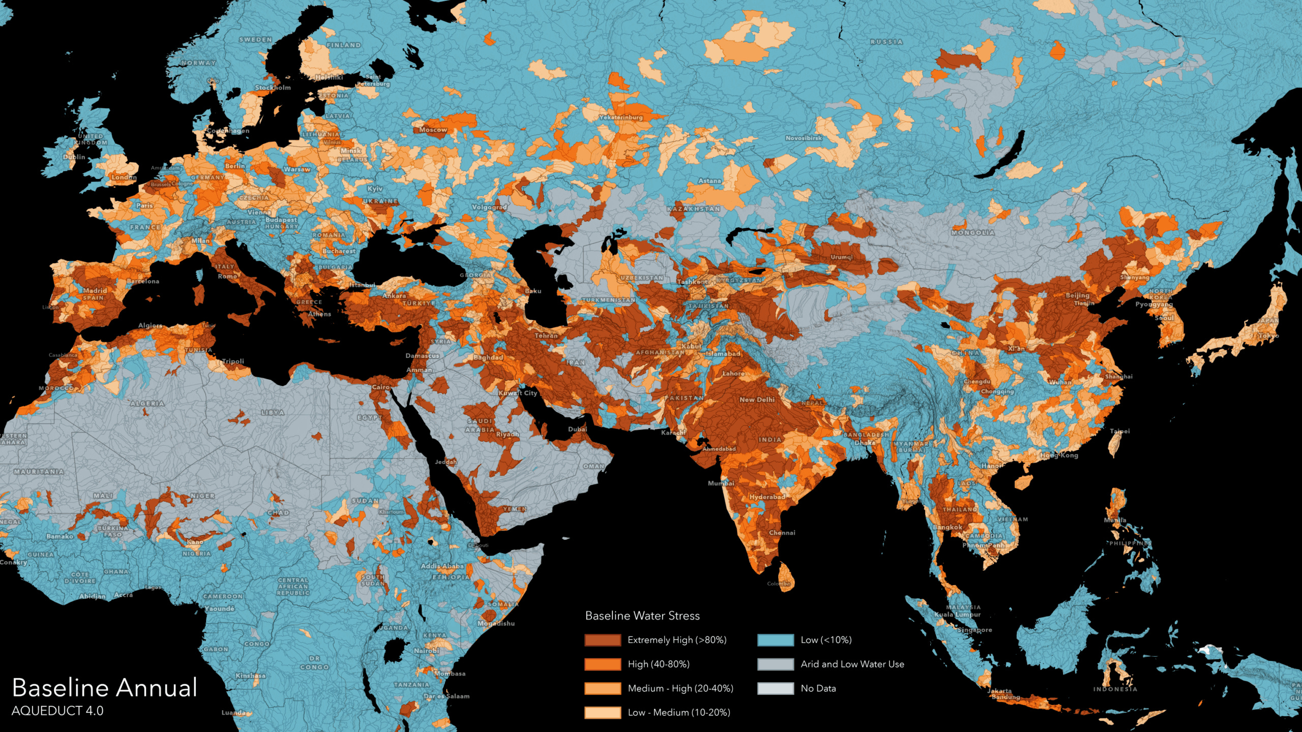
Global Water Risk from Aqueduct in Living Atlas [link]
Aqueduct 4.0 Global Water Risk data from WRI is now available in ArcGIS Living Atlas, bringing high-resolution, current and future water stress indicators into GIS workflows to support water management, policy, and climate resilience planning.
Snapshots
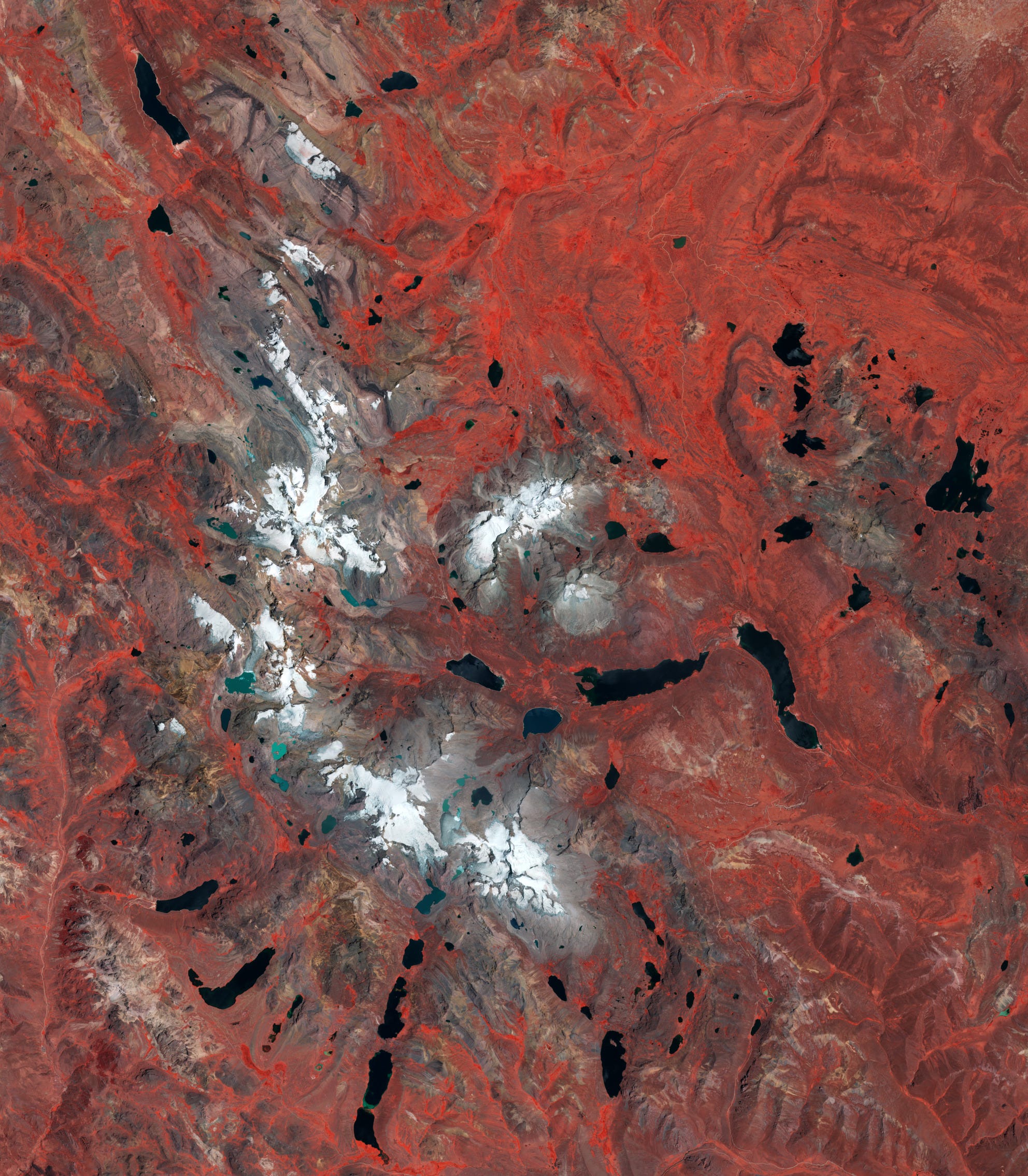
Earth from Space: Pariacaca Mountain Range, Peru [link]
"Following International Mountain Day, which creates awareness of the importance of mountain environments around the world, the Copernicus Sentinel-2 mission takes us over the Pariacaca Mountain Range in Peru.
Also called the Huarochirí mountain range, the Pariacaca range is a significant part of the Peruvian central Andes, the Cordillera Central. Pariacaca is known for its beautiful and rugged peaks, many of them reaching over 5000 m in height."
Interesting read
Satellites help tackle landfill methane leaks [link]
"Satellites are emerging as a powerful new tool in the fight to curb emissions of methane. While methane is much shorter-lived in the atmosphere than carbon dioxide, it is vastly more potent at trapping heat, which makes rapid cuts essential for slowing warming in the short term. The same satellite technology that has transformed methane monitoring in the oil and gas sector is now being turned towards another major source – landfill sites."
Seven things we learned from the UN World Urbanization Prospects [link]
“Urbanisation is reshaping the world at a pace which has surpassed earlier expectations, altering how people live and how societies plan for housing, transport, and essential services. A new analysis from the UN World Urbanization Prospects 2025, drawing on harmonised global settlement data from the Copernicus Emergency Management Service’s Global Human Settlement Layer datasets, reveals a series of shifts challenging long-standing assumptions. Tokyo is no longer the world’s largest city, the proportion of urban dwellers has been greatly underestimated, and five more unexpected findings reshape our understanding of where people live today.
This week’s Observer explores seven key insights from the report and what they mean for the planet’s urban future.”
Quantifying local climate regulation in three Estonian cities [link]
Estonia has completed its first national attempt to quantify how urban vegetation cools cities, focusing on Tallinn, Tartu, and Narva. Using Copernicus tree cover data, NASA land surface temperature, and evapotranspiration datasets, the study maps how green spaces reduce urban heat at both local and city-wide scales. The results reveal clear cooling hotspots in parks and urban forests and lay the groundwork for integrating ecosystem services directly into spatial planning and climate adaptation strategies.
Satellites Detect Seasonal Pulses in Earth’s Glaciers [link]
"Malaspina Glacier in southeastern Alaska is the planet’s largest piedmont glacier, with ice that spills from the Saint Elias Mountains’ higher elevations and spreads out like pancake batter onto the coastal plain. Though it might appear static, the glacier is “alive” with movement throughout the year, typically speeding up in spring and slowing to a crawl by winter. A new analysis by NASA scientists shows that glaciers around the world display all kinds of patterns in seasonal movement—some similar to Malaspina and some vastly different."

The Black Sea Kerch Strait’s maritime accident oil spill simulations in December 2024 [link]
"On 15 December 2024, the Volgoneft 212 tanker broke apart near the Kerch Strait during severe storm conditions, releasing approximately 4,000 tons of mazut. The extent of the spill was difficult to assess, as high waves limited the use of satellite SAR imagery.
To support the emergency response, researchers from Orion Research, MHI-RAS, Mare Investigatorium Studia, and Rowell Computing used the MEDSLIK oil spill model.
Their simulations reproduced the observed drift and coastal deposition of oil between Veselovka, Anapa and Utrish, as confirmed by RadarSat and European Space Agency - ESA SAR images.
This Use Case demonstrates how Copernicus Marine data can support a rapid, evidence-based response to marine pollution events, thereby improving preparedness and cooperation across the Black Sea region."
Land Use Changed the Climate. Now Climate’s Changing the Land [link]
"Land-use change has long been recognized as a major contributor to global warming. Deforestation and agriculture alone account for nearly 25% of human-caused greenhouse gas (GHG) emissions.
One might think this effect is uni-directional: Cutting down trees, plowing up grasslands and draining wetlands release GHGs that fuel climate change. But satellite monitoring shows that this relationship is a two-way street. Climate change itself is increasingly leading to the loss and degradation of forests, grasslands, wetlands, rivers and even farms, creating a dangerous feedback loop."
The Earth Observation Conundrum [link]
Earth Observation still struggles to scale; not for lack of demand, but due to a structural, system-level mismatch. The industry remains fragmented by modalities, poorly integrated across analytics and delivery, and locked into area-based pricing shaped by intrinsic EO cost mechanics rather than customer value. True adoption, this piece argues, will only come through systems thinking: tightly integrating multi-modal sensing, analytics, and workflow delivery into outcome-driven products.
Beyond the Hype: Element 84’s Pragmatic Vision for AI in Engineering [link]
Element 84 shares a practical take on using AI in engineering, focusing on clear value, human responsibility, and high-quality software. Rather than chasing hype, AI is positioned as a tool to support engineers while keeping security, maintainability, and client trust front and center.
Advancing Hyperspectral Data with the Third Atmospheric Correction Inter-Comparison eXercise (ACIX-III) [link]
ACIX-III has delivered a comprehensive benchmark of atmospheric correction algorithms for PRISMA and EnMAP hyperspectral missions, highlighting both strengths and persistent challenges across land and water surfaces. The results provide critical guidance for improving reflectance retrievals and supporting upcoming imaging spectroscopy missions such as CHIME and SBG.
Climate
A Subtle Return of La Niña [link]
La Niña returned to the equatorial Pacific in September 2025 and has persisted into December, though this event remains relatively weak and its broader climate impacts are still uncertain. Strengthened trade winds have cooled the central and eastern Pacific, a signal observed in sea surface height data from the Sentinel-6 Michael Freilich satellite, where cooler, denser water leads to lower sea levels. These oceanic changes influence the exchange of heat and moisture with the atmosphere, with potential effects on global circulation patterns. However, as NOAA and NASA scientists note, weak La Niña events are often difficult to predict and do not always produce typical regional weather outcomes.
Competitions
EOPF Zarr Community Notebook Competition [link]
"Your challenge is to write a educational Jupyter Notebook showcasing what is possible with Sentinel-1, 2 or 3 data in the new Zarr format. All are welcome!"
Submission Deadline: 30 Jan 2026, 23:59 (UTC+1)
TerraMind Blue-Sky Challenge [link]
"A bi-monthly award spotlighting the boldest, most imaginative ways to push TerraMind beyond “just another fine-tune”. Whether you’re prototyping a new multi-modal workflow, exploring Thinking-in-Modalities, or inventing a never-seen geospatial application, we want you to share it with everyone."
DualityAI<>LunateAI - Geospatial Object Detection [link]
"Train a model to detect buildings in aerial satellite or drone geospatial images of a rural environment."
Deadline: Jan 12, 2026
PlanetLabs is on fire! It's stock languished around $3 for years and has now shot up to $17