

Level-2 News
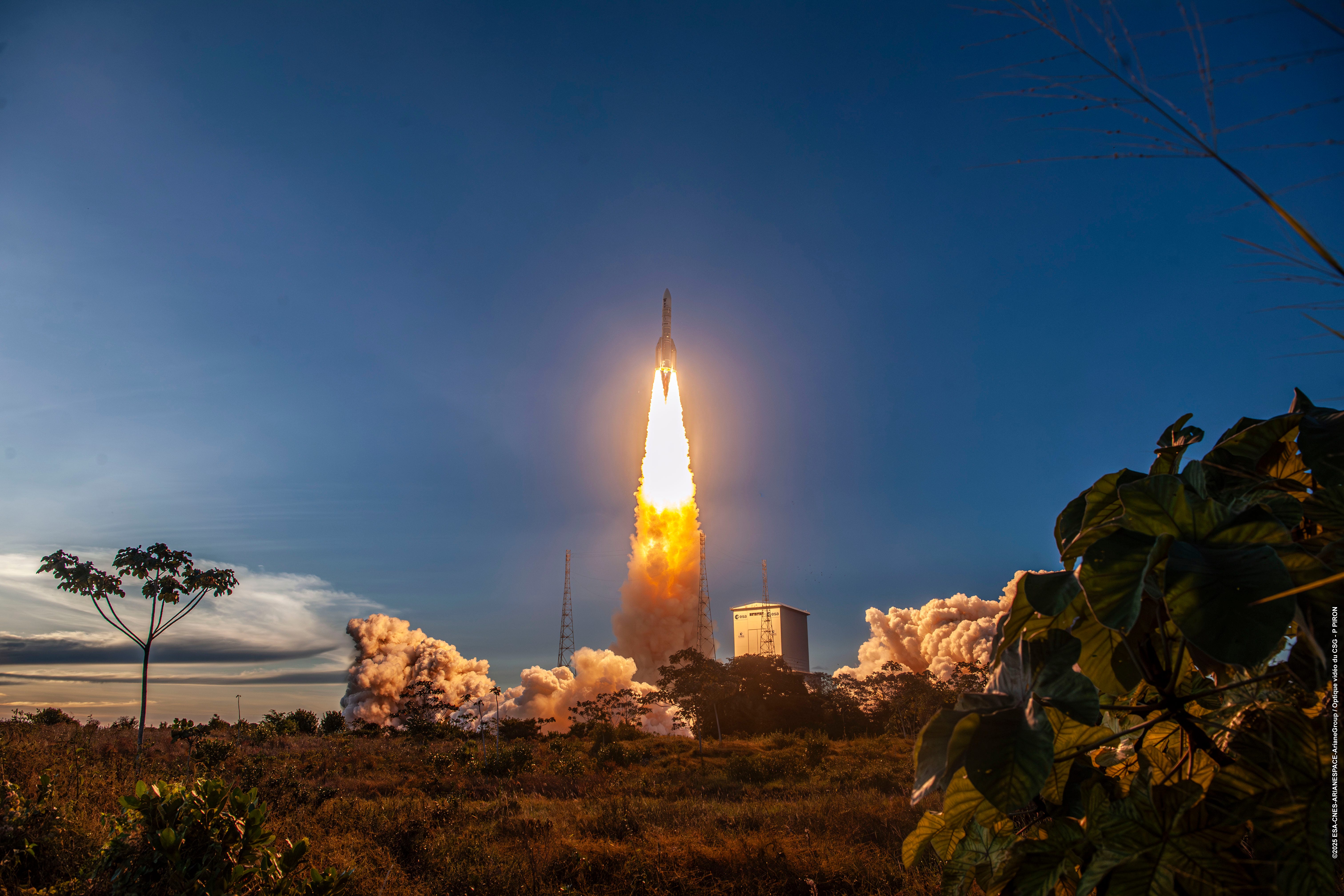
Ariane 6 launches Sentinel-1D [link]
"The Copernicus Sentinel-1D satellite has joined the Sentinel-1 mission in orbit. Launch took place on 4 November 2025 at 22:02 CET (18:02 local time) on board an Ariane 6 launcher from Europe’s Spaceport in French Guiana."
ESA’s HydroGNSS Scout satellites ready for launch [link]
"After arriving at the California launch site at the end of September, the two HydroGNSS satellites have been carefully prepared for liftoff, scheduled this month.
HydroGNSS – a twin-satellite mission – marks the European Space Agency’s first ‘Scout’ venture. By harnessing signals from navigation satellites, HydroGNSS will help scientists gain new insights into key climate variables linked to water."
Rheinmetall and ICEYE establish joint venture in Neuss [link]
"The technology group Rheinmetall and ICEYE, have completed the establishment of their joint venture, Rheinmetall ICEYE Space Solutions GmbH, based in Neuss, Germany. As the majority shareholder, Rheinmetall AG holds 60 per cent of the shares in the joint venture, while ICEYE Oy holds 40 per cent."
Space4Good to expand rainforest protection with new funding [link]
"Space4Good has successfully closed a funding round led by Arches Capital, with participation from Empower Impact and Indigo Ventures!
Specifically, funding will enable Space4Good to:
Further scale FORESTER in tropical regions across Southeast Asia, Latin America, and Africa, bringing trusted forest insights to teams on the ground.
Have product learnings across varying customers, leading to ever ever-improving product suite.
Grow Space4Good’s team and operations to meet growing international demand for verifiable environmental data.
Weekend SpaceX Bandwagon Mission Launches 18 Payloads to Mid-Inclination Orbit [link]
SpaceX’s Bandwagon-4 rideshare mission carried 18 payloads to mid-inclination orbit. The launch included several Earth Observation missions. Among them, three ICEYE-built SAR satellites for Space42, a LEMUR-2 satellite from Spire Global, and two weather-monitoring satellites from Tomorrow.io.
Rocket Lab launches “The Nation God Navigates” to join SAR constellation for Japan [link]
"“The Nation God Navigates” launched from Rocket Lab Launch Complex 1 in New Zealand at 19:51 UTC on November 5, 2025, deploying QPS-SAR-14, nicknamed YACHIHOKO-I for the Japanese god of nation-building, to a 575km circular Earth orbit.
This satellite joins the rest of the QPS-SAR constellation in providing high resolution synthetic aperture radar (SAR) images and Earth monitoring services globally. iQPS aims to build a constellation of 36 SAR satellites that will provide near-real-time images of Earth every 10 minutes."
Developer's Orbit
Introducing OlmoEarth Platform: Powerful open infrastructure for planetary insights [link]
AI2 has released the OlmoEarth Platform, an open system that helps turn satellite, radar, and elevation data into up-to-date environmental insights. It’s built on the OlmoEarth foundation model, trained on millions of Earth observations and easy to adapt for tasks like crop mapping, wildfire risk, or deforestation monitoring. The platform includes open code, APIs, and tools such as OlmoEarth Studio and Viewer for building and sharing custom Earth observation models.
Related:
OlmoEarth: A new state-of-the-art Earth observation foundation model family [link]
GitHub: olmoearth_pretrain - Earth system foundation model data, training, and eval [link]
OlmoEarth models on HuggingFace [link]
Technical report [link]
Introducing wkls: A Python Library for Instantly Accessing Global Administrative Boundaries [link]
"Wherobots introduced Well Known Locations (wkls), a Python library for instantly accessing global administrative boundaries.
If you’ve ever spent hours searching for shapefiles, hardcoding coordinates, or maintaining boilerplate code just to define a city or country boundary, this one’s for you.
With wkls (”Whickles”), you can access more than 625K global administrative boundaries from countries to cities in a single, clean, chainable Python syntax."
Releasing lonboard 0.13! [link]
"Lonboard is a Python library for fast, interactive geospatial vector data visualization in Jupyter.
What’s new in Lonboard version 0.13:
New layer types: H3, S2, Geohash, A5 and fixed HeatmapLayer
Interleaved rendering with Maplibre: render data layers beneath Maplibre text labels
Map UI elements (”controls”): scale, fullscreen, navigation
Significant performance improvements: fixing earlier regressions"
A new release for PROPAGATOR: advancing wildfire modeling [link]
The CIMA Research Foundation announced that a new release of PROPAGATOR, wildfire spread simulation model, is now available as an open-source project on GitHub.
GitHub: https://github.com/CIMAFoundation/propagator_sim
Docs: https://cimafoundation.github.io/propagator_sim/0.0.2/
Paper: PROPAGATOR: An Operational Cellular-Automata Based Wildfire Simulator [link]

Data
Φ-lab Interactive AIS Map [link]
“This data access provides globally collected Automatic Identification System (AIS) data, structured and organized on a daily basis for consistent access and analysis. Lightweight utilities to fetch and normalize AIS (Automatic Identification System) data from the AIS Hub webservice.”
From Legacy CSVs to Cloud-Native Geodata [link]
"Development Seed rebuilt Canada’s Spatial Access Measures dataset to show what happens when public data meets modern tools. By converting the legacy CSVs to GeoParquet and running them through DuckDB-WASM and deck.gl, they created an interactive map that works entirely in the browser. It’s fast, lightweight, and ready to explore."
Demo: https://developmentseed.org/spatial-access-measures/
GitHub: https://github.com/developmentseed/spatial-access-measures/
Snapshots
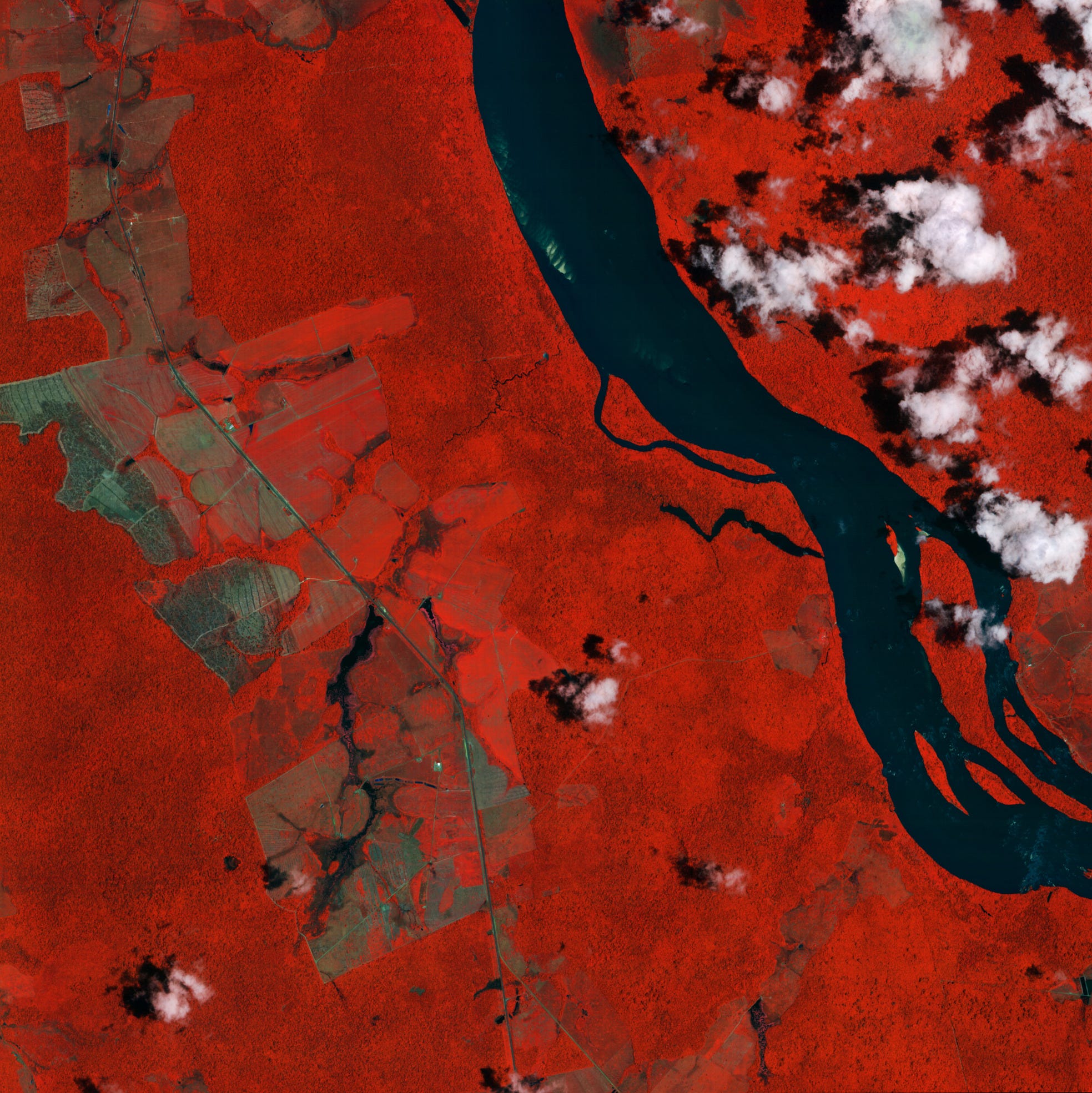
Earth from Space: Branco River, Brazil [link]
"As 30th UN Climate Change Conference of the Parties (COP30) takes place in Belém, Brazil, from 10-21 November, this image shows the Branco River and its surrounding forests in the Brazilian state of Roraima. It was captured by IRIDE’s Hawk for Earth Observation (HEO) constellation, launched earlier this year."
Interesting reads
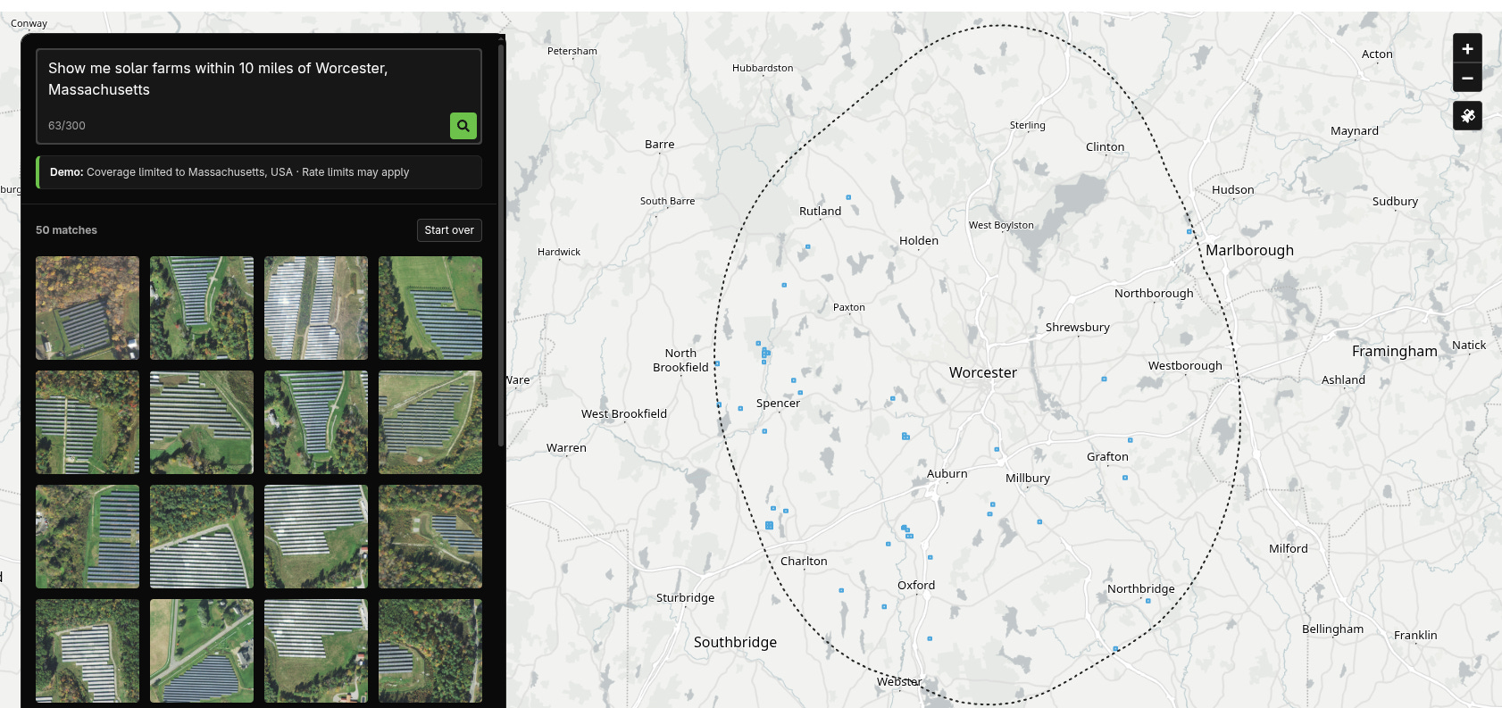
Queryable Earth [link]
Element84 released Queryable Earth, a demo that showcases natural-language search across satellite imagery. Built on top of vision-language foundation models (VLMs) and LLMs, the system translates text queries, like “Find wetlands near Cape Cod”, into vector embeddings and matches them against pre-indexed satellite imagery of Massachusetts.
This approach is powered by models such as SkyCLIP and RemoteCLIP, which align satellite imagery and natural language in a shared embedding space. Instead of training models for specific object detection tasks, these VLMs understand what the image depicts in broader, semantic terms, making it possible to query imagery at scale through plain language.
Exploring a space-based, scalable AI infrastructure system design [link]
Google announced Project Suncatcher, an ambitious initiative to build solar-powered AI data centers in space. The project envisions constellations of satellites equipped with Tensor Processing Units (TPUs) and free-space optical links to run machine learning directly in orbit, leveraging solar energy. Prototype satellites, developed in partnership with Planet, are scheduled for launch in 2027.
Related:
Preprint Paper: Towards a future space-based, highly scalable AI infrastructure system design [link]
Planet to Build and Operate Advanced Space Platform for Google’s Project Suncatcher Moonshot [link]
A Parallel Effort:
Startup Starcloud has launched Starcloud-1 on November 2 aboard SpaceX’s Bandwagon-4 rideshare mission, to demonstrate orbital GPU compute using NVIDIA H100 hardware ; a parallel effort to Google’s Project Suncatcher, both advancing the vision of space-based AI infrastructure powered by solar energy and satellite-to-satellite links.
Related:
How Starcloud Is Bringing Data Centers to Outer Space [link]
Powerful NVIDIA chip launching to orbit next month to pave way for space-based data centers [link]
Cameras, GIS, and Why Tools Don’t Make You Special Anymore [link]
Follow this post by Daniel O’Donohue, where he reflects on the future of geospatial experts in an era when the bar to access and use geospatial tools keeps getting lower.
Programmer installed and ran Doom on an orbiting European Space Agency satellite [link]
"There were lots of interesting topics discussed in the recent Ubuntu Summit, but one in particular might just tickle the fancy of most any techie above 30: the story of how Doom was actually running in space. Programmer Ólafur Waage recounted the tale of when his team took part in the European Space Agency’s hacking challenge and got the seminal game running on a satellite."
Beyond the Echo - How satellites steer the radar beam [link]
ICEYE explains how satellites use hybrid (mechanical/electronic) steering to capture multiple radar images in a single pass, making it possible to follow features like rivers, roads, or other curved paths with high precision..
LinkedIn Highlights
When satellites miss what communities see [link]
Follow this LinkedIn post by Tobias Baumann, where he breaks down new research in Scientific Reports by Iheaturu et al. (University of Bern). The study reveals a striking “scale mismatch” between what satellites report and what communities experience.
Interpreting Embedding Dimensions by Samuel Barrett [link]
Upcoming Events
Training course: Numerical methods for weather prediction [link]
"This course describes contemporary methods, recent advancements, and current challenges in numerical techniques used across a broad range of weather prediction models for solving the governing equations of atmospheric dynamics on High-Performance Computing (HPC) systems. The methods covered are relevant to short and medium-range forecasting, seasonal prediction, climate modelling, and both global and limited area simulations."
ECMWF | Reading | 13-17 April 2026
Applications for this course close on 30 November 2025
Opportunities
Water Resources Specialist at FAO [link]
Manufacturing Deployment & AIT Manager at ICEYE (Greece) [link]
Satellite Production Intern at ICEYE (Finland) [link]
Geospatial Image Analyst at ICEYE [link]
Senior Product Manager, Monitoring Imagery at Planet (US) [link]
Digital Health and Geospatial health Consultant Roster at UNICEF [link]
PhD Opportunity at University of Cambridge: AI for Geohazard Early Detection [link]
Multiple Postdoctoral Fellowships at The Department of Land Surveying and Geo-Informatics at The Hong Kong Polytechnic University [link]