

Living Planet Fellowship call for proposals 2025 [link]
ESA invites young researchers in ESA Member States to submit scientific proposals to the Living Planet Fellowship Call 2025. The LPF aims at supporting the new generation of scientists in ESA Member States to undertake cutting-edge research in Earth Observation and Earth System and Climate Science that may maximise the scientific impact of ESA missions and European EO capacity and respond to the main challenges of the new ESA Earth Observation Science Strategy: Earth Science in Action for Tomorrow’s World.
Submission deadline – 14th November 2025
Level-2 News
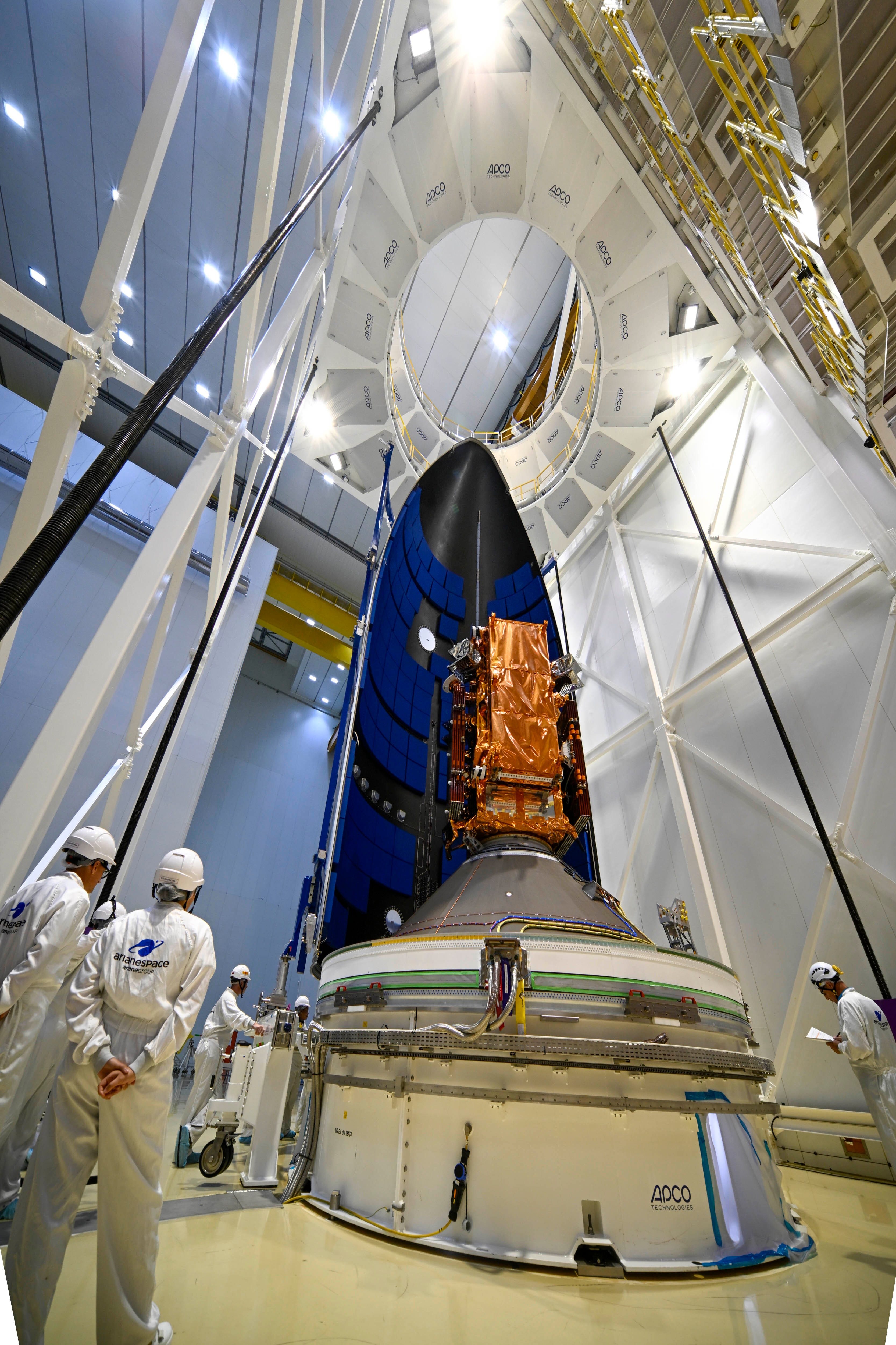
Sentinel-1D encapsulated inside Ariane 6 fairing [link]
"The Copernicus Sentinel-1D satellite has been encapsulated inside the Ariane 6 fairing at Europe’s Spaceport in French Guiana.
Encapsulation is when the satellite is placed inside the protective ‘nose cone’ of the rocket, known as the fairing. It is the final view of the satellite before launch, which is scheduled for Tuesday, 4 November at 22:03 CET."
Watch live: Sentinel-1D launch on Ariane 6 [link]
"The Copernicus Sentinel-1 mission is about to get its fourth satellite, with Sentinel-1D now ready for liftoff. Launch will take place with an Ariane 6 rocket from Kourou, French Guiana and live coverage will be shown on Tuesday, 4 November, at 22:02 CET (18:02 at Kourou)."
N° 64 - 2025: Decisions and announcements following 337th ESA Council [link]
The 337th ESA Council meeting brought a series of decisions shaping Europe’s space and Earth observation agenda. Cyprus is set to become an Associate Member of ESA, marking another expansion of the European space ecosystem. ESA also strengthened its global partnerships, while approving the next phase of the Destination Earth (DestinE) digital twin initiative. Significant progress was also made on the Atlantic Constellation, enhancing Europe’s ability to monitor climate change from space.
Key Highlights
Cyprus to join ESA as Associate Member, pending ratification.
ESA x WFP MoU (5 years): Accelerating the use of space data for food security and emergency relief worldwide.
DestinE moves to Phase III: Targeting a high-accuracy digital twin of Earth by 2030; Phase III begins mid-2026.
Support to Spain expanded: ESA to assist with launch and early operations of Spain’s first Atlantic Constellation satellite (part of a 16-sat EO constellation with Portugal).
ESA x NASA cooperation on Vigil: NASA to contribute the JEDI instrument for improved solar activity monitoring from L5.
Ministerial Council preparations underway — final decisions expected in Bremen on 26–27 November, with an extraordinary Council on 7 November.
Airbus, Thales, and Leonardo Agree to Create European Space Behemoth [link]
"European aerospace giants Airbus, Leonardo, and Thales have signed a memorandum of understanding to combine their respective space businesses into a single new company. Ownership will be shared among the three parent firms, with Leonardo and Thales each holding a 32.5% stake, and Airbus holding the majority stake of 35%. The new company, which will employ approximately 25,000 people, will be managed jointly under a “balanced governance structure.”"
Arianespace Pushes First Ariane 64 Flight Back to 2026 [link]
"Arianespace has confirmed that the first flight of the more powerful, four-booster variant of the Ariane 6 rocket will not be launched until 2026."
ABB Wins Canadian Space Agency Environmental Monitoring Contract [link]
"ABB, a Swedish tech company, has won a contract from the Canadian Space Agency to carry out the conceptual development (Phase A) of the Thin Ice Clouds and Far InfraRed Emissions (TICFIRE) instrument. It will be a component of the High-altitude Aerosols, Water Vapor and Clouds (HAWC) satellite mission – a Canadian-led initiative focused on advancing climate science and environmental monitoring. ABB announced the contract win, Oct. 23."
Iceye Strengthens Position in Central Europe with New Slovakian Partner [link]
"Iceye is strengthening its position in central and Eastern Europe. It is forming a strategic partnership with EMIS, a provider of geospatial information systems in Slovakia, to expand access to critical, near real-time hazard information for Slovak authorities. The two companies announced the partnership, Oct. 23."
Developer's Orbit
Google Earth AI - Geospatial Reasoning: New updates and more access to Google Earth AI [link]
"With Geospatial Reasoning you can use Gemini-powered agents to access these models for rapid analysis and insight, helping your organization make decisions at AI speed and scale. In this video, we ask the agent to predict when Hurricane Helena will make landfall, using Google’s Cyclone prediction model. This video is of a demonstration application built with the Geospatial Reasoning framework and has been edited for brevity.
To learn more, visit ai.google/earth-ai."
Related:
Technical Blog: Google Earth AI: Unlocking geospatial insights with foundation models and cross-modal reasoning [link]
Technical Paper: Earth AI: Unlocking Geospatial Insights with Foundation Models and Cross-Modal Reasoning [link]
Detecting War Crimes from Space - Building an Open-Source Pipeline with SQLMesh and DuckDB [link]
"If you’re getting the feeling recently that there’s more war in the world, you’re right. Compared to 2010 the number of armed conflicts have more than doubled. Centre for Information Resilience (CIR) aims to provide digital witness accounts using open source data and tools.
This blogpost by Tom Uijtdehaag is a technical deep dive into how they built an open-source pipeline to detect burn events in a collaborative effort between CIR and BigData Republic (BDR)."
GitHub Repository [link]
STAC is an official OGC community standard!
The Open Geospatial Consortium (OGC) announced the publication of the SpatioTemporal Asset Catalog (STAC) Community Standards.
Read the full announcement [link]

Data
NASA’s Harmonized Landsat and Sentinel-2 (HLS) Data Now Available on Microsoft’s Planetary Computer [link]
"NASA’s vast archive of Earth observation data has long been a cornerstone for scientific discovery, environmental monitoring, and global sustainability efforts. Now, Microsoft has made it even easier for researchers, developers, and decision-makers to access and utilize this critical resource. Through a collaboration with NASA, the Harmonized Landsat and Sentinel-2 (HLS) dataset is now available on Microsoft Azure by using Microsoft’s Planetary Computer platform."
VIIRS Global Burned Area Product Added to FIRMS [link]
"The global burned area product from Visible Infrared Imaging Radiometer Suite (VIIRS) aboard the Suomi National Polar-orbiting Partnership (Suomi NPP) satellite has been added to the Fire Information for Resource Management System (FIRMS). This NASA standard science product (VNP64A1) provides continuity to the Moderate Resolution Imaging Spectroradiometer (MODIS)-generated NASA standard science burned area product (MCD64A1) and uses an adaptation of the same algorithm used to generate MCD64A1 Collection 6.1."
World Bank Global Administrative Divisions [link]
"A new, high-resolution global dataset of administrative boundaries—covering countries (ADM0), states or provinces (ADM1), and districts (ADM2)"
Related:
Mapping progress: How the World Bank is improving access to global administrative boundaries [link]
Snapshots
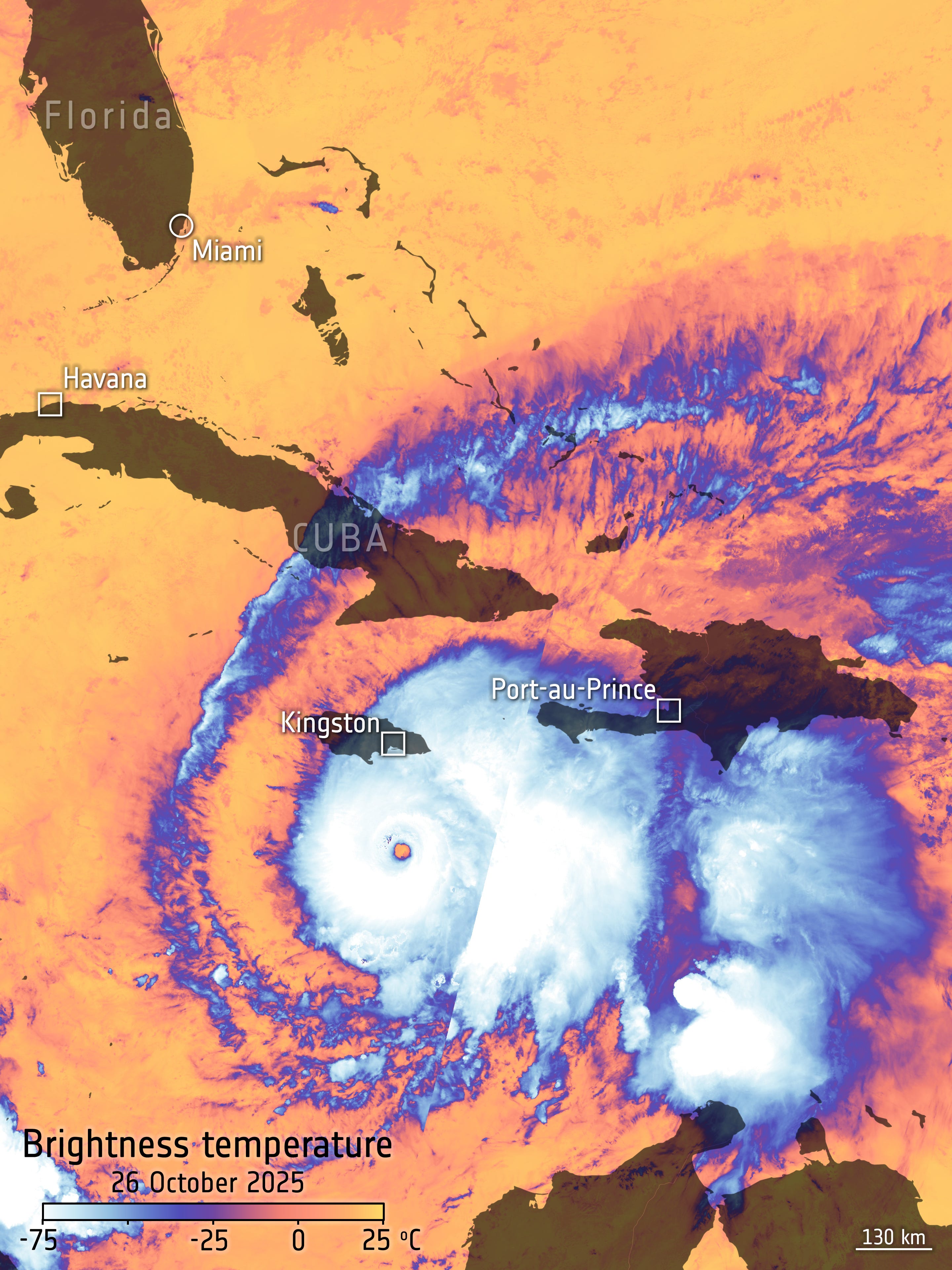
Hurricane Melissa barrels through the Caribbean [link]
"Classified as a Category 5 storm by the US-based National Hurricane Center, Hurricane Melissa is the world’s strongest storm so far this year.
The brightness temperature of the clouds at the top of the storm, high above the ocean, range from about –75°C near the eye of the storm to about –25°C at the edges. The temperature of the surrounding ocean is much warmer, reaching as high as 25°C. This image has been overlaid with the landmasses below."
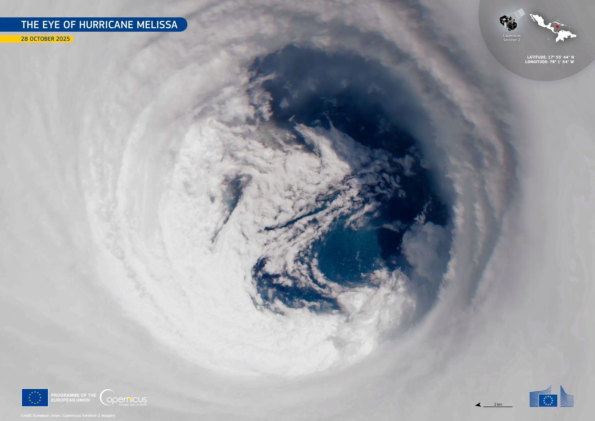
Peering into the eye of Hurricane Melissa [link]
Sentinel-2C satellite captured Hurricane Melissa just as the hurricane was making landfall.
Interesting reads
Sentinel-4 offers first glimpses of air pollutants [link]
"The new Copernicus Sentinel-4 mission has delivered its first images, highlighting concentrations of atmospheric nitrogen dioxide, sulphur dioxide and ozone. Despite being preliminary, these images mark a major milestone in Europe’s ability to monitor air quality all the way from geostationary orbit, 36 000 kilometres above Earth."
With the launch of Sentinel-6B, Europe builds on its ocean monitoring legacy [link]
"As November approaches, the EU Space Programme is preparing for its next milestone in Earth Observation (EO): the launch of Copernicus Sentinel-6B, the second of two identical satellites in Europe’s sea-level monitoring mission. Set to launch from Vandenberg Space Force Base in California, the satellite carries a sophisticated radar altimetry instrument capable of measuring sea-surface height with centimetre precision, providing essential data for understanding climate change and protecting coastal communities worldwide. This Observer post looks at how the Copernicus Sentinel-6 satellite mission continues a thirty-year record of ocean altimetry with the launch of Sentinel-6B, ensuring continuity and precision in what has been an active year of satellite deployments for the EU Space Programme."

Air Quality Challenges in 2025: Europe’s Summer of Smoke, Dust and Ozone [link]
"The summer of 2025 significantly affected Europe’s atmosphere. From record-breaking wildfires in southern and western Europe, to intense Saharan dust intrusions and repeated peaks in surface ozone during prolonged heatwaves, air quality was negatively impacted by multiple events. Data from the Copernicus Atmosphere Monitoring Service (CAMS) show how these overlapping events combined to create serious risks for human health and the environment across the continent."
Common Practices for Quantifying Methane Emissions from Plumes Detected by Remote Sensing [link]
"CEOS & CGMS are shared the publication of the “Common Practices for Quantifying Methane Emissions from Plumes Detected by Remote Sensing”
Developed through collaboration across the international community, this document outlines recommended practices for generating, validating, and reporting methane emission estimates from detected plumes. It aims to improve transparency, consistency, and interoperability across datasets and missions."
Warmer oceans mean fewer reflective clouds [link]
"A case study by EUMETSAT’s Dr Rob Roebeling and his team demonstrate how satellite data can be used confirm the effects of warmer oceans on marine stratocumulus clouds and explore what this means for our future climate."
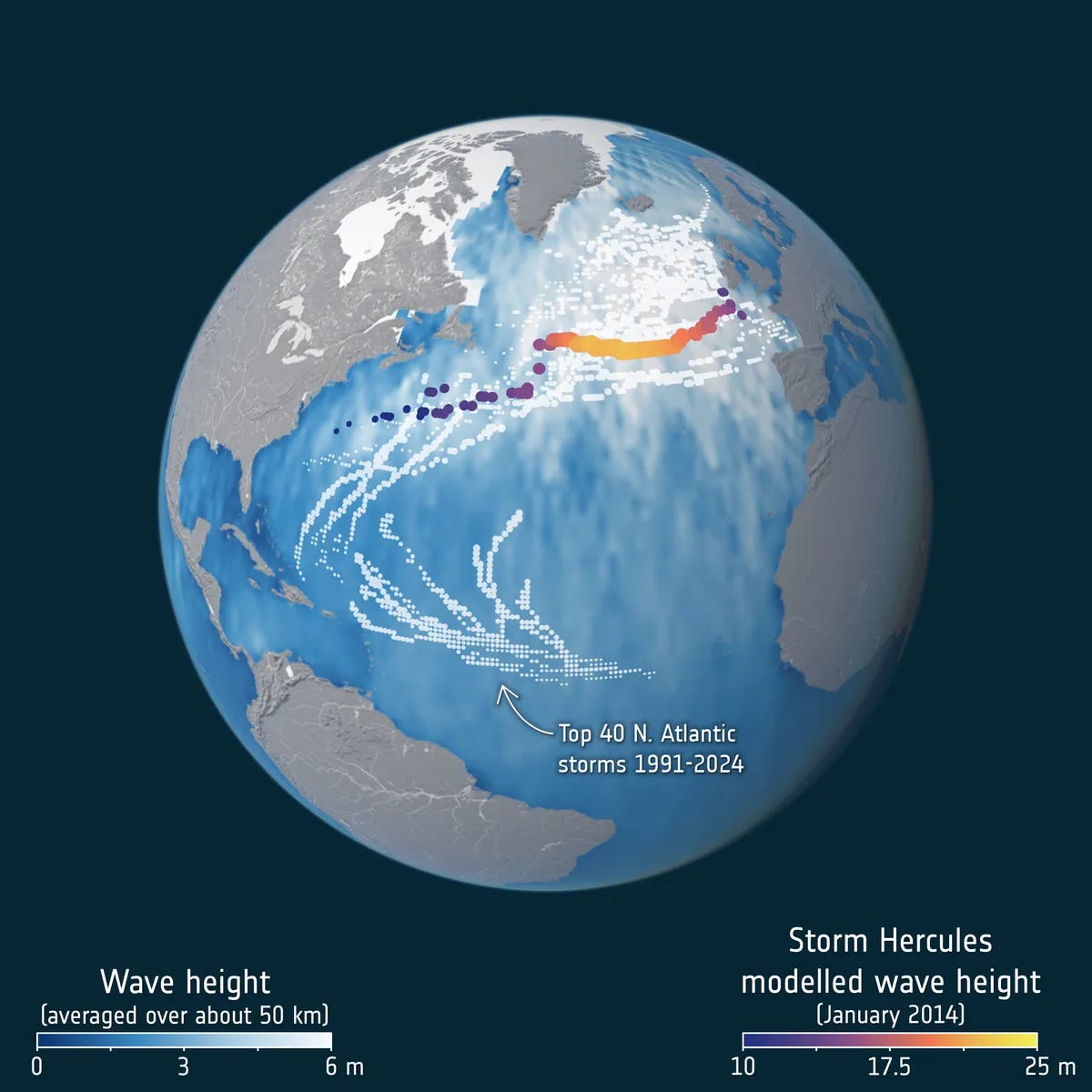
Satellites watch as record-breaking ocean waves carry a storm’s power across the sea [link]
"Satellite data from the SWOT mission reveals how massive waves act as storm “messengers,” carrying a storm’s power across entire oceans."
Upcoming Events
AI Meets EO Education: Smarter Content for Smarter Learning [link]
"Artificial intelligence is reshaping the way we design and deliver training. Across the Earth observation (EO) and geospatial community, educators are beginning to use AI tools to generate learning materials, create localized examples, and produce interactive content that connects more effectively with learners around the world.
This interactive webinar will explore how AI can empower EO trainers by making their daily work easier, faster, and more effective. Participants will see real-world demonstrations of AI-assisted tools, including ESA’s EVE, and learn how emerging virtual assistants are being developed to make complex data more accessible to learners everywhere."
12 November 2025 | 13:00–14:30 UTC | Online
Opportunities
Visiting Researchers in onboard AI for Φ-sat-2 mission [link]
Learning
Why a SAR image is not your usual optical one [link]
Follow this post by Elise Colin to explore the key differences between Synthetic Aperture Radar (SAR) and optical imagery.
Fascinating. It's inspiring to see Europe's dedication to Earth observation. With the Living Planet Fellowship and missions like Sentinel-1D, how do you envision the increased data impacting climate models, and what role will advanced AI play in predicative analytics? Your insights are always so valuable.