

NASA-ISRO Satellite Sends First Radar Images of Earth’s Surface [link]
"The NISAR (NASA-ISRO Synthetic Aperture Radar) Earth-observing radar satellite’s first images of our planet’s surface are in, and they offer a glimpse of things to come as the joint mission between NASA and ISRO (Indian Space Research Organisation) approaches full science operations later this year."
Level-2 News
Planet Releases First Light Image From Pelican-3; Multiple Pelican Launches Slated for the Next Year [link]
"Planet released first light images from its Pelican-3 satellite of Turin, Italy. It was taken on September 5, 2025, from an altitude of 458 km. Image quality is expected to improve as the spacecraft complete the instrument calibration process and reach their final operational orbits. "
Planet Ships 2 More Pelicans and 36 SuperDoves to Launch Site [link]
"Planet announced its Pelican-5 and Pelican-6 satellites and 36 SuperDoves of Flock 4H have arrived at Vandenberg Space Force Base in California ahead of their launch aboard the upcoming Transporter-15 Rideshare mission with SpaceX."
Planet and VITO Extend Long-Term Partnership to Accelerate Earth Observation Solutions for Agriculture and Environment [link]
"Planet and VITO announced an extension to their long-term partnership to accelerate the use of Earth observation for global impact. By bringing together Planet’s daily, global satellite imagery and VITO’s analytics and service platforms, the partners will deliver faster, more actionable insights for agriculture, global monitoring and environmental resilience."
Milestone for MicroCarb: First Earth Observations [link]
"On 28 August, the MicroCarb satellite captured its first view of Earth, marking a major milestone following its 25 July launch. The first images and measurements come from the Amazon Basin — a region that plays a crucial role in the global carbon cycle but where very few ground-based CO₂ observations exist."
"Carbon Dioxide Monitoring Mission (MicroCarb) is a microsatellite mission by the French Space Agency, CNES, with support from the UK Space Agency (UKSA), launched in July 2025. Considered a successor to other carbon dioxide missions such as Greenhouse gas Observing Satellite (GOSAT) and Orbiting Carbon Observatory-2 (OCO-2), the objective of MicroCarb is to monitor the fluxes of carbon dioxide between the atmosphere, oceans and vegetation." [link]
HydroGNSS mission lands in California [link]
"The UK-built HydroGNSS mission, which will investigate the Earth’s water cycle, has landed in California and is ready to start preparations for launch. Built by Surrey Satellite Technology Ltd (SSTL), in Guildford, HydroGNSS-1 and HydroGNSS-2 are part of the European Space Agency’s Scout programme – delivering rapid, low-cost Earth observation missions.
Once in orbit, the pair will track climate variables like soil moisture and flooding, using signals from existing GNSS satellites in innovative new ways. "
Maxar retires its name, rebrands as Vantor and Lanteris [link]
"The Maxar name is disappearing from the space industry as two successor companies emerge with distinct identities: Maxar Intelligence will now operate as Vantor, and Maxar Space Systems will go by Lanteris."
Albedo Drops its Commercial Imagery Business [link]
"Albedo Space, the Colorado startup operating the Clarity-1 imaging satellite in VLEO, is getting out of the commercial imagery game.
Albedo CEO Topher Haddad told Payload the company will abandon its imaging business to focus entirely on building VLEO satellite buses for other payload operators—a decision which includes laying off an undisclosed number of employees.
The shift comes in response to the better-than-expected success of Clarity-1, as well as market signals that VLEO demand will continue to increase for defense and commercial missions."
KSAT launches Integrated Mission Services [link]
"KSAT announced a new end-to-end offering that provides satellite owners with a seamless solution for mission operations, ground network access, and data delivery.
As the number of small satellites and large constellations continues to grow at unprecedented speed, IMS enables satellite owners to scale efficiently while reducing the burden of managing in-house ground infrastructure and operations teams.
KSAT’s Integrated Mission Services bundles launch support, satellite operations, and mission monitoring into a single subscription."
Developer's Orbit
scikit-eo - A Python package for Remote Sensing Data Analysis [link]
scikit-eo provides a rich suite of algorithms specifically designed for environmental studies. These include statistical analysis, machine learning, deep learning, data fusion and spatial analysis.
Researchers can leverage these tools to explore patterns, relationships, and trends within their datasets, to uncover complex land or forest degradation or mapping and classify the land cover, and generate insightful visualizations, among others tools.
Data
AgERA5 in Climate Engine was updated to version 2 [link]
AgERA5 in Climate Engine was updated to version 2, which comes with substantial updates. The big update is the new Penman-Montieth Reference ET (ETo) variable that is provided. This enables users to use existing functionality available in Climate Engine to calculate derived water balance and drought indicators such as the potential water deficit, the evaporative demand drought index (EDDI), and the standardized precipitation evapotranspiration index (SPEI).
AgERA5 is a global daily climate reanalysis dataset produced at a 0.1° resolution with about a one-week latency, enabling global assessment of drought conditions. It also contains snow indicators such as snow depth and snow water equivalent (SWE) and vapor pressure deficit (VPD).
Learn more about AgERA5 in Climate Engine [link]
Access the Google EarthEngine collection [link]

Snapshots
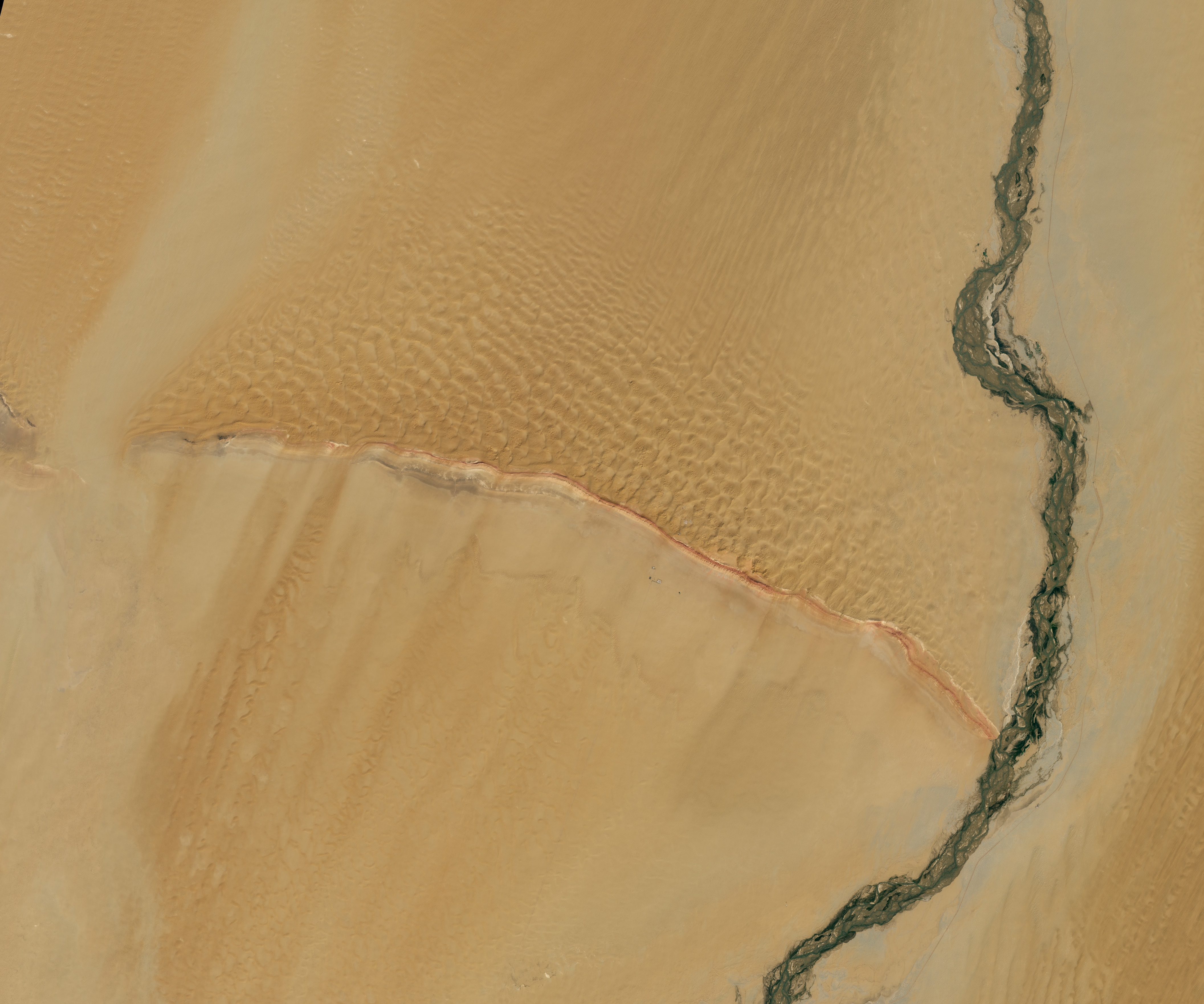
A Desert Intersection [link]
"In the Tarim Basin in western China, a curved ridge and winding river converge in a Y-shaped tangle of sand, rock, and water channels. Even from space, it’s easy to see why the colorful ridge—Mazartagh—is known in Chinese as Hongbaishan, or “red-white mountain.”
The OLI-2 (Operational Land Imager-2) on Landsat 9 acquired this image on September 11, 2025, showing where the river meets the ridge. The wall-like ridge stretches 145 kilometers (90 miles) to the northwest and rises about 200 meters (600 feet) above the surrounding desert. It acts as a natural barrier, trapping sand and blocking dunes from moving southward under the basin’s frequent northeasterly winds.
The Hotan River (also called the Khotan River) is a seasonal feature fed by glacial meltwater from the Kunlun Mountains, which line the basin to the south. The river carries large summer flows northward across the Takla Makan Desert until it meets the Tarim River in the far northern part of the basin."
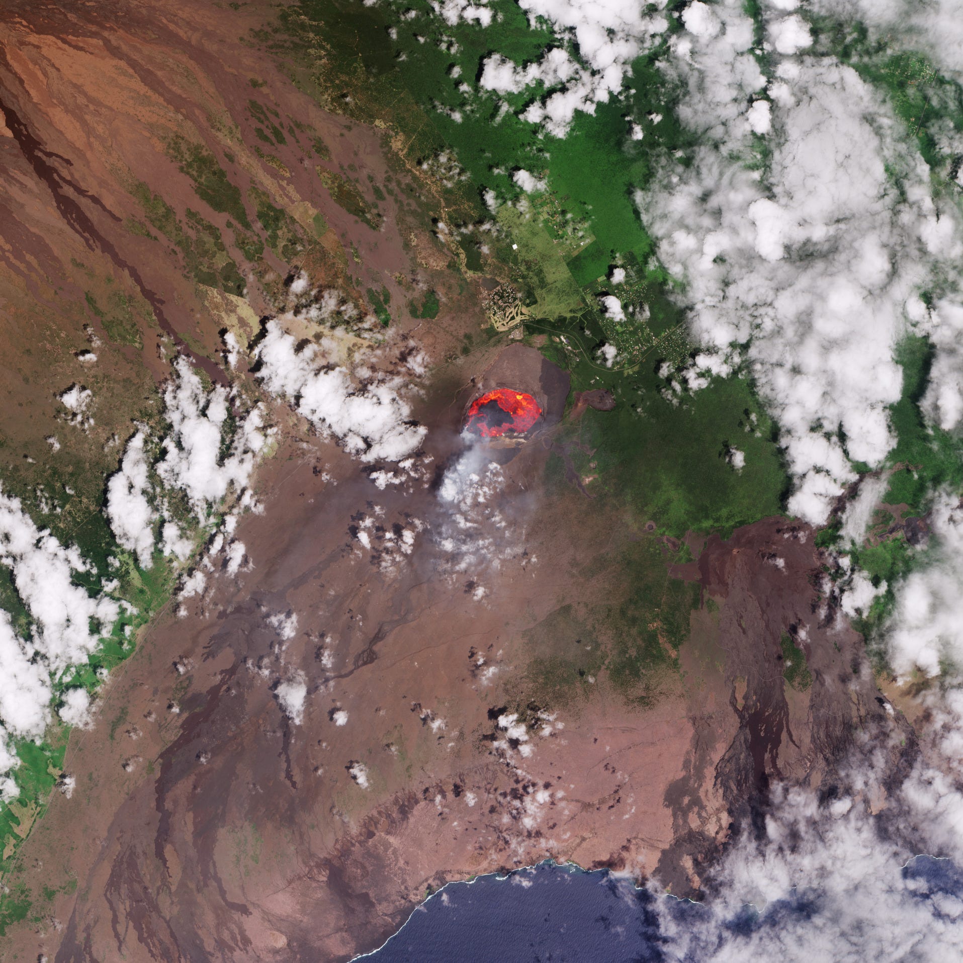
Earth from Space: Kilauea lava lake, Hawaii [link]
"Located in the central Pacific Ocean, Big Island is the southeastern-most island in the US state of Hawaii and, as its name suggests, the largest in the archipelago. Having formed above a magma hotspot in the Pacific plate, Hawaii has some of the world’s largest active volcanoes. One of these is Kilauea on the southeastern side of Big Island.
This Copernicus Sentinel-2 image from 3 September 2025 shows a lava lake approximately 2.5 km in length, inside the main crater of Kilauea. Following an eruptive episode on 2 September, lava fountains reached about 100 m high and lava flowed from multiple vents in the main crater.
Although the image has been processed in natural colour, the mission’s shortwave infrared channels, which detect heat sources, were also used to highlight the fiery lava flowing from the crater in orange and red. Plumes of smoke can also be seen leaking from the crater."
Interesting reads

Understanding the long-term impact of earthquakes on slopes [link]
"When the ground trembles during a powerful earthquake, the danger doesn’t end once the shaking stops. Hidden threats like landslides and floods often emerge later, putting lives and infrastructure at risk weeks, months, or even years after the main event.
Collapsed buildings and fast-moving landslides make headlines, but earthquakes destabilise far more than what we see right away. Slopes destabilized by seismic shaking can slowly accelerate, eventually causing delayed landslides or floods. These long-term hazards remain poorly understood.
While much of today’s research focuses on co-seismic landslides (those that happen immediately during the quake), the AMHEI (Advancing knowledge of multi-hazards processes and their impact) project aims to uncover how slopes evolve in the months and years following a major earthquake, and how these changes might influence landslide and flood hazards."
Educating customers may be half the battle for nascent hyperspectral sector [link]
"A major barrier for hyperspectral startups isn’t launching satellites - it’s teaching customers what to do with the data. Companies like Kuva Space, Wyvern, and Pixxel are investing heavily in customer education through online training, hands-on demonstrations, and AI-powered interfaces that make exploring hyperspectral cubes more intuitive. Pixxel’s Aurora platform even lets users chat with their data, asking questions like “What am I looking at here?” to uncover insights once reserved for experts. As these efforts expand, education may prove just as critical as innovation in driving hyperspectral adoption."
Countdown to launch – Copernicus Sentinel-1D lifts off in November [link]
“2025 is another milestone year for the EU Space Programme.
Following the successful expansion of Copernicus with the launch of Sentinel-5A and Sentinel-4A earlier in the year, on 4 November 2025, Sentinel-1D will lift off from Europe’s Spaceport in Kourou, French Guiana, ensuring the continuity of services on which a wide range of end users rely worldwide.
Sentinel-1D joins Sentinel-1C, launched in December 2024. Both satellites are equipped with Galileo-enabled receivers for more accurate in-orbit positioning and carry an Automatic Identification System (AIS) payload which detects signals from ships, supporting maritime domain awareness and the detection of unauthorised activities at sea. Sentinel-1D’s launch aboard Ariane 6 reflects Europe’s growing capacity to put its satellites into orbit on its own terms, strengthening the resilience of Copernicus Services and the EU’s strategic autonomy.
This week’s Observer looks at the upcoming launch and the benefits the Sentinel-1 mission delivers.”
Climate
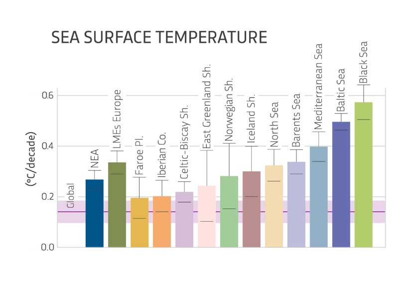
The 9th Edition of the Copernicus Ocean State Report warns that climate change, biodiversity loss, and pollution currently affect all ocean basins [link]
"This year’s edition of the Copernicus Ocean State Report (OSR 9) highlights the deep and widespread links between ongoing ocean change and changes in marine ecosystems, human society, and the economy.
The global ocean is affected by record-breaking temperatures, accelerating sea level rise, and continued acidification, with no part of the ocean untouched by what the UN has termed the triple planetary crisis of climate change, biodiversity loss, and pollution.
The OSR 9 also highlights the importance of regional monitoring as a complement to global assessments and showcases new and improved monitoring systems and frameworks to help track the state of the ocean."