

Level-2 News

Landsat Celebrates Major Open Data Milestone [link]
"On July 14, 2025, downloads of Landsat products passed 200,000 terabytes (TB). This milestone highlights the vast scale of the Landsat archive and growing demand for its data.
This achievement stems from the 2008 policy change that made all Landsat products available for download from the U.S. Geological Survey for no-charge. In the last 17 years, scientists, land managers and the public have used this resource to understand the changes on our landscapes around the world. "
Planet Reports Financial Results for Second Quarter of Fiscal Year 2026 [link]
Planet had a strong Q2 FY2026, reaching record revenue of $73.4M (+20% YoY), generating $85M in operating cash and $54M in free cash flow so far this year. The company’s future business pipeline also surged, with backlog climbing to $736M. Key wins included a €240M multi-year contract with the German government, along with deals with NATO and the U.S. Navy, plus renewals with the UK RPA and SwissRe. On the technology side, Planet launched two new high-resolution Pelican satellites, expanding its next-generation constellation.
Planet Launches Two Additional High-Resolution Pelican Satellites [link]
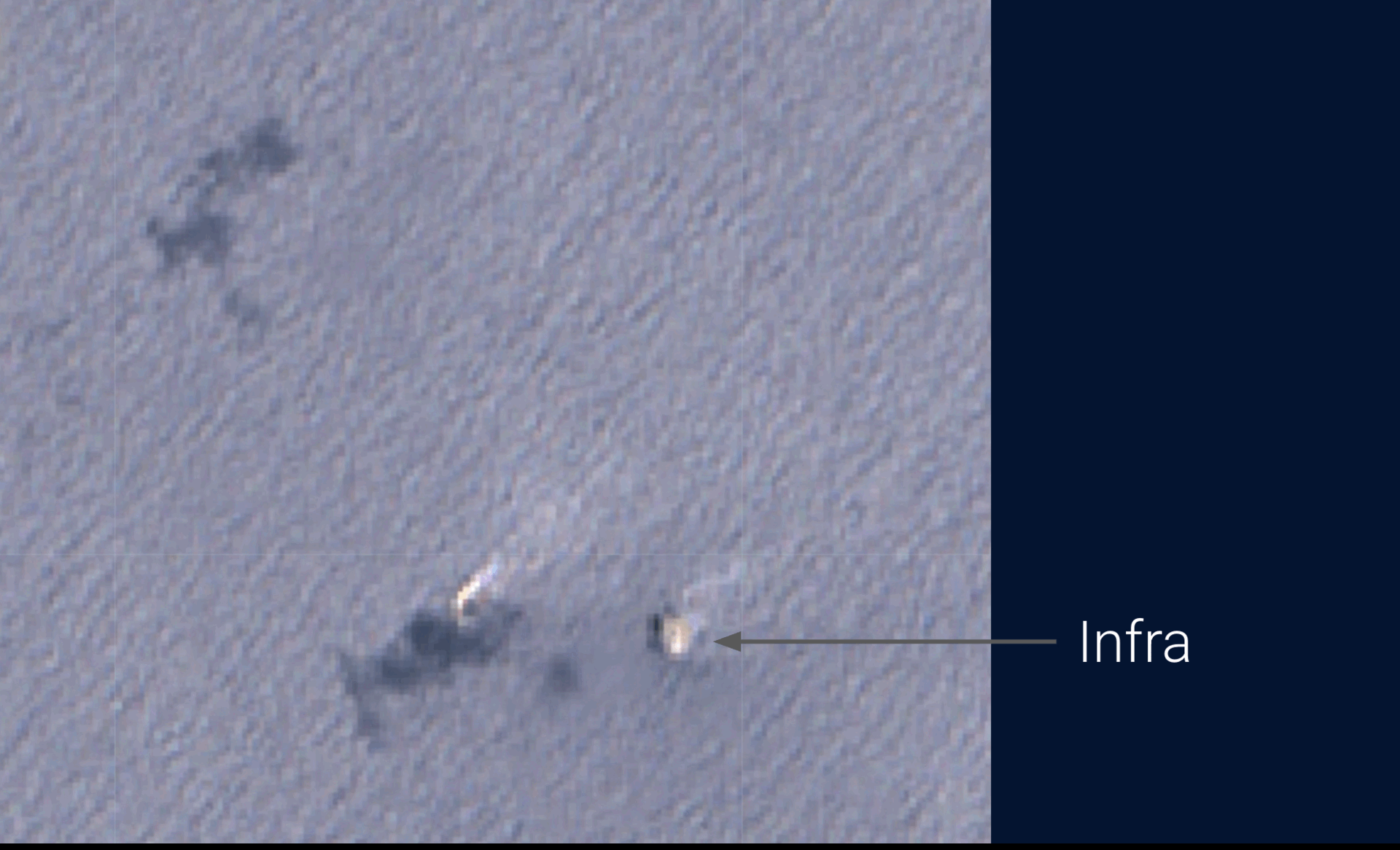
"Planet announced that its high-resolution, AI-enabled Pelican-3 and Pelican-4 satellites were successfully launched to orbit on SpaceX’s Falcon 9 rocket from Vandenberg Space Force Base in California. The Planet team has successfully made contact with Pelican-3 and Pelican-4 and started the commissioning processes for these satellites.
Joining Pelican-1 and Pelican-2, Pelican-3 and Pelican-4 are the latest additions to Planet’s fleet of next-generation tasking satellites. Planet plans to launch additional Pelicans this year.
As Gen 1 Pelican satellites, Pelican-3 and Pelican-4 are built to provide up to 40 cm class resolution imagery across 6 multispectral bands optimized for cross-sensor analysis. Through Planet’s partnership with NVIDIA, these Pelicans are equipped with NVIDIA Jetson AI platforms to enable rapid on-orbit computing and the swift delivery of insights to customers."
SatVu, IHI Partner on Thermal Mapping Constellation [link]
"British space-based infrared mapping startup SatVu has partnered with Japan industrial company IHI Corporation to develop a high-res thermal infrared satellite constellation."
Related:
IHI collaborates with SSTL to develop Earth observation satellite constellation [link]
Satellogic Maps Out Exclusive India Deal with Suhora [link]
"Satellogic has signed a multi-year, seven-figure exclusive deal with Suhora Technologies, handing the Indian geospatial intelligence company distribution rights to Satellogic’s EO data in India and Nepal."
Esper Satellites Sends its Hyperspectral Sensor to Orbit [link]
"Australian startup Esper Satellite Imagery launched its Over the Rainbow-2 (OTR-2) hyperspectral camera to orbit yesterday—flying as a hosted payload aboard Dhruva Space’s LEAP-1 mission.
The payload, a near-infrared sensor, aims to help customers in agriculture, mining, and defense to better understand the minerals hidden beneath the surface of the planet. "
New Hyperspectral Satellite Startup Messium Targets Crop Monitoring [link]
"U.K.-based startup Messium looks to use hyperspectral satellites to monitor nitrogen in crops. The company announced a 3.3 million euro ($3.9 million) seed round this week, led by UK Innovation & Science Seed Fund (UKI2S) and Expansion Aerospace Ventures."
Idaho to Deploy Satellite-Based Wildfire Detection With OroraTech [link]
"The Idaho Department of Lands will deploy a statewide satellite-based wildfire detection and monitoring system through a new partnership with OroraTech USA.
OroraTech said Sept. 10 that the system uses both public and its own proprietary wildfire satellites and other public data sources. It is designed to provide fire location, intensity, and predicted spread. The company said this information can be shared with dispatch centers and firefighters within minutes."
Sumitomo Corporation Invests in Ursa Space [link]
"Sumitomo Corporation of Americas has invested into Ursa Space Systems to help the company serve customers across Asia, particularly in the Japanese market. The firm is the largest subsidiary of Japanese conglomerate Sumitomo Corporation."
Eutelsat partners with Skynopy to explore opening OneWeb ground stations to Earth observation [link]
"Eutelsat has teamed up with French satellite connectivity startup Skynopy to explore offering Earth observation operators spare capacity on the ground stations used for OneWeb, its low Earth orbit (LEO) broadband service.
The partnership will test reusing some of the Ka-band antennas across 42 OneWeb sites worldwide, Skynopy announced Sept. 11, a move that would represent a major expansion from the startup’s current network of 30 S- and X-band antennas across 15 sites."
GHGSat Satellites Deployed to Monitor Methane at Scale Across ExxonMobil’s Onshore Operations [link]
"ExxonMobil Corporation and GHGSat, announced a partnership to monitor and mitigate methane at scale across ExxonMobil’s onshore operations in North America and Asia, including the United States, Canada, Papua New Guinea, and Indonesia."
BlackSky and Iceye join group creating Earth’s digital twin [link]
"BlackSky and Iceye have joined forces with AI-visualization specialists Aechelon Technology and Niantic Spatial to create a digital twin of Earth. "
Developer's Orbit
SkyTruth Released a Codebase for Offshore Methane Detection [link]
"The repository contains experimental tooling for detecting offshore methane emissions using Sentinel-2 imagery. The codebase grew out of SkyTruth's research efforts and includes utilities for pixel masking, MBSP raster generation and plume polygon extraction."
Blog Post [link]
titiler-eopf - TiTiler application for EOPF dataset [link]
As part of the EOPF Explorer, Development Seed developed titiler-eopf, tailored from titiler-xarray using obstore to serve data from S3 object storage.
Follow this LinkedIn post for more.
Related:
We Needed Better Cloud Storage for Python so We Built Obstore [link]

Snapshots
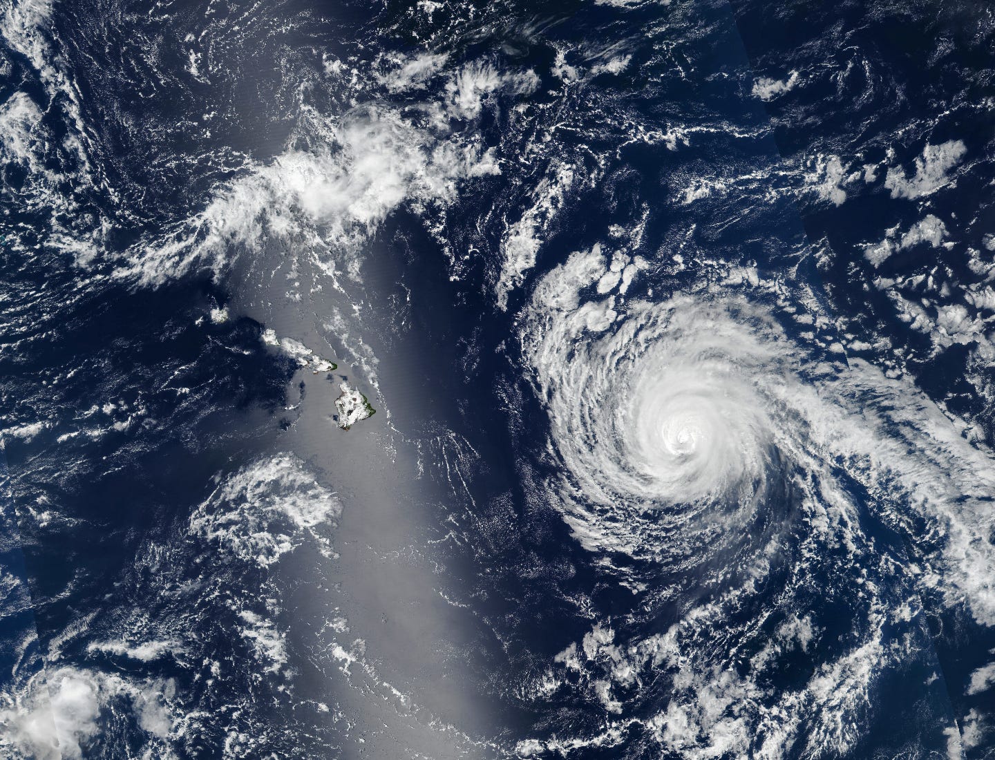
Hurricane Kiko Nears Hawaii [link]
"Developing as a tropical depression in the eastern Pacific on August 31, 2025, Kiko intensified into a major hurricane while churning west toward the Hawaiian Islands. The storm weakened as it approached land and was forecast to skirt the islands to the north. Still, the state braced for dangerous surf from the passing storm.
The VIIRS (Visible Infrared Imaging Radiometer Suite) on the Suomi NPP satellite acquired this image of Hurricane Kiko at about 1:30 p.m. Hawaii Standard Time (23:30 Universal Time) on September 7, when it was approximately 600 miles (1,000 kilometers) east of Hilo. At that point, Kiko had sustained winds of 110 miles (175 kilometers) per hour, according to the National Hurricane Center (NHC), making it a Category 2 hurricane on the Saffir-Simpson wind scale."
Interesting reads
How Copernicus supports news coverage [link]
"Satellites provide a unique vantage point from above, enabling unparalleled observation of global events. Whether monitoring floods using radar data or providing insights into deforestation through optical imagery, the Copernicus Sentinel missions are instrumental in capturing the state of our planet in remarkable detail. Beyond their ability to help us monitor the Earth, Copernicus images also inform the public and empower storytellers and journalists to communicate environmental narratives in engaging and accessible ways.
Today’s Observer explores how Copernicus supports journalists around the world in sharing compelling stories about our planet with their audiences."
New U.S.-European Sea Level Satellite Will Help Safeguard Ships at Sea [link]
"Sea surface height data from the Sentinel-6B satellite, led by NASA and ESA, will help with the development of marine weather forecasts, alerting ships to possible dangers.
Because most global trade travels by ship, accurate, timely ocean forecasts are essential. These forecasts provide crucial information about storms, high winds, and rough water, and they depend on measurements provided by instruments in the ocean and by satellites including Sentinel-6B, a joint mission led by NASA and ESA (European Space Agency) that will provide essential sea level and other ocean data after it launches this November."
Climate
La Niña may return but temperatures are likely to be above average [link]
"La Niña may return to impact weather and climate patterns from September onwards, according to the latest World Meteorological Organization (WMO) El Niño/La Niña update. But despite the temporary cooling influence of La Niña, temperatures are still expected to be above average for much of the world."
Upcoming Events
A new era in Forest and Land Cover Monitoring [link]
"The Copernicus Land Monitoring Service (CLMS) is delighted to invite you to an in-depth webinar on the newly launched Land Cover and Forest Monitoring (LCFM) product suite. This event will take place on 25 September 2025, offering a unique opportunity to explore ground-breaking developments in global land-cover observation."
EOPF Zarr Hackathon: Driving Innovation in Cloud-Native Earth Observation [link]
"As part of this year’s Big Data from Space (BiDS25) conference, the EOPF Zarr Hackathon will offer a unique opportunity for the Earth Observation community to come together and explore cutting-edge, cloud-native technologies aimed at transforming how we access and process data from the Copernicus Sentinel missions.
This webinar is a joint effort between our service and the EOPF toolkit team, reflecting a shared commitment to advancing open, cloud-native approaches to Earth Observation.
Designed for participants of all levels, from newcomers to advanced users, the hackathon will focus on collaborative problem-solving and hands-on experimentation with the Earth Observation Processing Framework (EOPF) and its growing suite of tools and data services."
Webinar 7 – EOPF Zarr Data Access with openEO and STAC [link]
"Join this webinar on 25 September for a practical webinar showcasing how to explore and process the new EOPF Zarr data products using openEO and STAC.
As part of the Earth Observation Processing Framework (EOPF) initiative, this session demonstrates how standardised, cloud-native approaches make Earth observation workflows more FAIR – Findable, Accessible, Interoperable, Reusable. Whether you are new to openEO or looking to test the latest Sentinel Zarr data formats, this webinar will guide you through data access, building customised virtual data cubes, and simple processing steps."
Competitions
ThinkingEarth Hackathon: Shaping the Future of AI for Earth [link]
"The ThinkingEarth project is inviting innovators, developers, and Earth science enthusiasts to its first Hackathon, taking place 29–30 September in Riga, Latvia, as part of the BiDS25 satellite events.
Participants will get hands-on with cutting-edge AI tools — from Copernicus-scale Earth Observation foundation models to graph-based weather forecasting and vision-language models — and co-create new solutions across three open tracks:
EO Foundation Models – Experiment with large-scale EO models and apply them to tasks like land cover mapping or biomass estimation.
Weather Forecasting Models – Compare, evaluate, and push the limits of AI-driven weather prediction.
EO Vision-Language Models – Explore how language and imagery can interact to make satellite data more accessible."
A bold new chapter for AI4EO with ‘ESA Φ-lab Challenges’ [link]
"With a new look and the same ambition, the rebranded ‘ESA Φ-lab Challenges’ return with a fresh momentum, inspiring the Earth observation and AI communities to drive innovation through a new series of impactful competitions."
Learning

Two-Day Fundamentals to Use Hyperspectral and Thermal Earth Observation Data Workshop Recordings Available Online [link]
"The two-day workshop event covers the fundamentals necessary to work with NASA's high-spectral resolution EO data, spanning the visible to short-wavelength infrared (VSWIR) and long-wavelength infrared (LWIR) parts of the electromagnetic spectrum. Presenters discuss measurement acquisition, standard pre-processing methods, data discovery, and working with key datasets from the Earth Surface Mineral Dust Source Investigation (EMIT), ECOsystem Spaceborne Thermal Radiometer Experiment on Space Station (ECOSTRESS), and Plankton, Aerosol, Cloud, Ocean Ecosystem (PACE) missions.
The webinar also includes tutorials on how to synergistically use these EO datasets and offers tutorials for using open-source code and cloud platforms, and JavaScript in Google Earth Engine (GEE)."
Agenda [link]
Fundamentals for Using Hyperspectral and Thermal Earth Observation Data (Day 1) [link]
From Space to Solutions: Access, Visualization, and Analysis Services for SWOT Hydrology [link]
Workshop Presentations [link]