

Level-2 News
NRO Contracts Hydrosat’s Thermal Imaging Data [link]
"Hydrosat announced a follow-on contract with the NRO, giving the DoD and intelligence community access to the company’s thermal imaging data through the NRO’s strategic commercial enhancements program.
The deal is a follow-on to a $1.2M Stage 1 contract Hydrosat won in 2023, which tasked the company with performing modeling and simulating services.
Since then, Hydrosat has placed two sats in orbit—VanZyl-1 and VanZyl-2. The Stage 2 contract will give the NRO access to thermal data for a combined 10M+ sq km of the Earth imaged every day."
BlackSky Blames Politics For Revenue Hiccup [link]
"BlackSky Technology told investors last week that its 2025 revenue forecast fell by $12M to $20M due to “anticipated impacts of US government budget uncertainties, and volatility in contract timing.”
The $BSKY disclosure is another data point for investors watching to see how EO companies will fare under the new Trump administration."
Planet Signs Contract Extension with Colombia’s IGAC for Land Management [link]
"Planet has signed a multi-year contract expansion with Colombia’s government entity responsible for geographic data to continue to use Planet’s technology for land management, adding AI capabilities to track change management in roads and buildings."
Maxar Nabs $205M in International Contracts for Defense and Intel Capabilities [link]
"Maxar Intelligence on July 8 said it received $204.7 million in new multi-year contracts from three existing customers in the Middle East and Africa (MEA) region to boost sovereign defense and intelligence capabilities for the undisclosed customers."
MethaneSAT Loses Contact With Satellite [link]
"Methane-monitoring satellite MethaneSAT has lost power and communications, the team behind the mission said in an update on Tuesday, July 1.
The MethaneSAT mission operations team lost contact with MethaneSAT on June 20, and the team learned on July 1 that the satellite lost power and is likely not recoverable."
Developer's Orbit
Orbio Earth open-sourced their codebase for satellite-based methane detection [link]
"Orbio Earth published a comprehensive tutorial to how they built their end-to-end methane pipelines over the last couple of years. Next to an extensive Q&A-like documentation, they are sharing large amounts of Orbio Earth’s production‑grade methane‑analytics pipeline—models, tooling, validation notebooks and reference datasets—released as open source under a non‑commercial licence."
"The repository contains
Trained models to detect methane plumes for Sentinel‑2, Landsat 8/9 and EMIT.
End‑to‑end notebooks covering inference and post‑processing to get from raw imagery to position and emission rates of methane plumes.
Synthetic‑plume toolkit that injects physically realistic methane signatures into clean scenes for training and stress‑testing."
GitHub Repository: [link]
Full Documentation [link]
LEGO Mosaic from Sentinel-2: A Hands-On Earth Observation Installation [link]
"Development Seed collaborated with the Copernicus Data Space Ecosystem to create a physical LEGO mosaic from Sentinel-2 satellite imagery, transforming Earth observation data into a tangible and collaborative installation. Using openEO by TiTiler, they processed and visualized data from the Copernicus archive into color-enhanced tiles that attendees at ESA’s Living Planet Symposium 2025 assembled in real time."
GitHub Repository [link]
Zarr in the Browser — Fast, Flexible, and Surprisingly Powerful for Big Geo Data [link]
"In this article, Tobias Ferreira explores strategies to visualize Zarr-based multidimensional geospatial data in the browser using tools like titiler-multidim, carbonplan/maps, and zarr-gl. He compares their rendering approaches, performance, and trade-offs between server preprocessing and client-side interactivity. He also covers traditional methods like converting to Cloud-Optimized GeoTIFFs (COGs) and using NetCDF with GeoServer."
The Model is Not the Map [link]
Follow this blog post by Christopher Ren where he argues that it's not enough to release a model and benchmark — deploying it on a real-world area is essential so people can assess its quality and performance beyond just the metrics.
A fast, flexible pipeline for 3D globe maps [link]
"Tim Meko built a quick-turn workflow to visualize forecast temperatures around the globe. It’s a modular pipeline that goes from raw forecast data to a polished 3D globe in a matter of minutes—adaptable for any global gridded dataset."

Snapshots
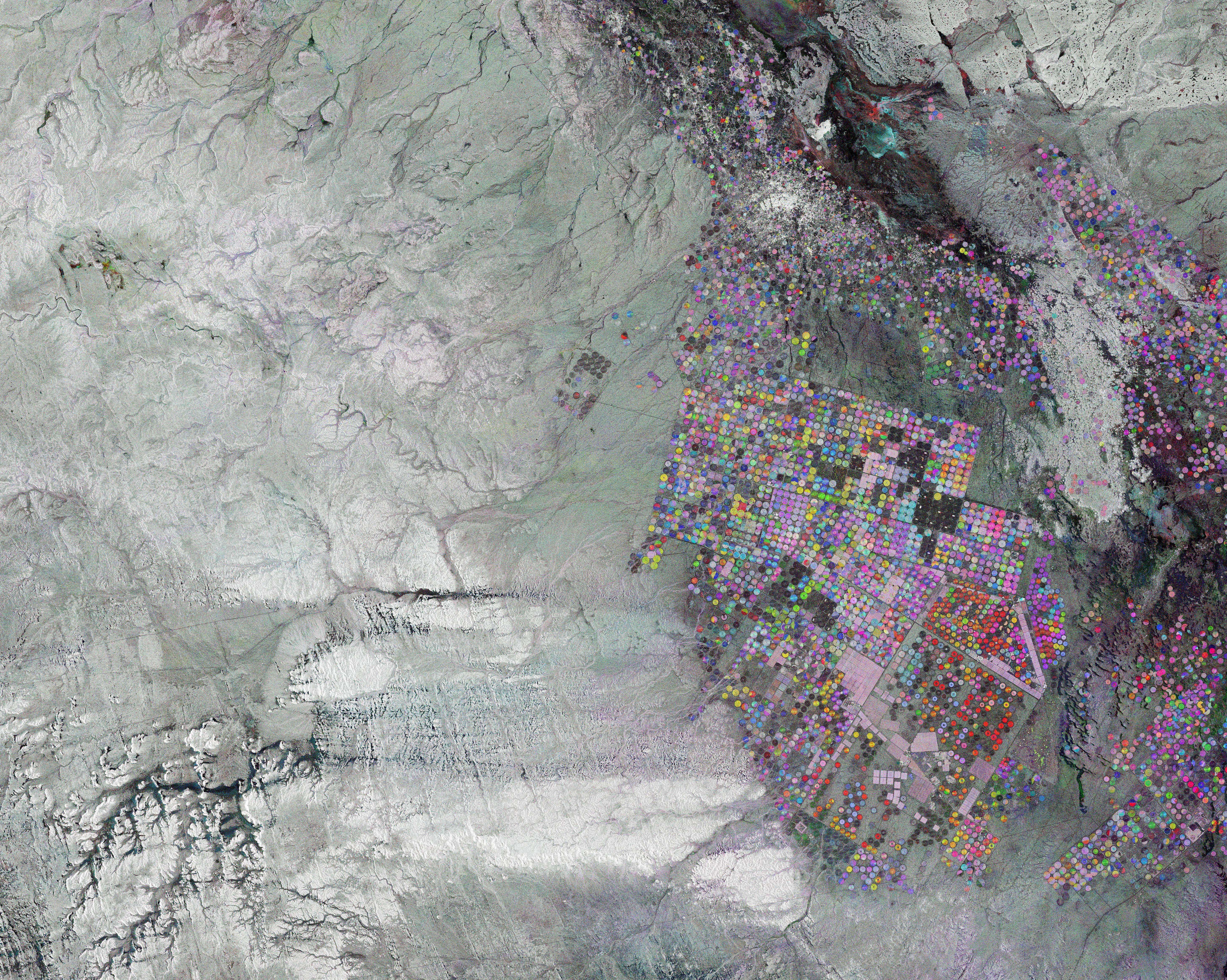
Earth from Space: Circles in the desert [link]
"This image from Copernicus Sentinel-1 shows circular agricultural structures near Tabarjal, in the barren desert of northern Saudi Arabia.
Most of Saudi Arabia has a desert climate and experiences temperatures as high as 50°C in summer. While there are virtually no permanent rivers or lakes in the country, large valleys called wadis fill with water during times of heavy rain. Most settlements are located along these valleys.
The area pictured lies within the Wadi As Sirhan basin and shows how Saudi Arabia’s desert is used for agriculture. Despite the dry climate, many irrigated crops are grown in the area.
The circles, each approximately one kilometre wide, are formed by central-pivot irrigation systems. These consist of a well at the centre of each circle, which supplies water from underground aquifers to rotating sprinklers. This type of irrigation helps farmers manage water in a more sustainable way to conserve this precious resource, which is not being replenished."
Interesting reads
A new app details where your food comes from — and just how fragile the global food system really is [link]
"A “first of its kind" tool could help untangle the complex global web of food supply chains and make it more resilient to climate shocks."
"Earth Genome announced the launch of Global Food Twin - a model of the world's entire food system!
They worked with Better Planet Laboratory to create a model that quantifies where food is produced, where it’s consumed, and maps every step of the supply chain. They also worked with Development Seed to turn this model into a proof of concept web application that allows a user to view food production across more than 3,700 global regions visualizing what food is produced, where it goes, who consumes it and how it gets there."
Explore the Global Food Twin web app [link]
GitHub Repo [link]
New Stories from Space: More Satellite Imagery in Data Journalism [link]
"Robert Simmon put together some of his favorite recent examples of data journalism that use satellite data as a key element."
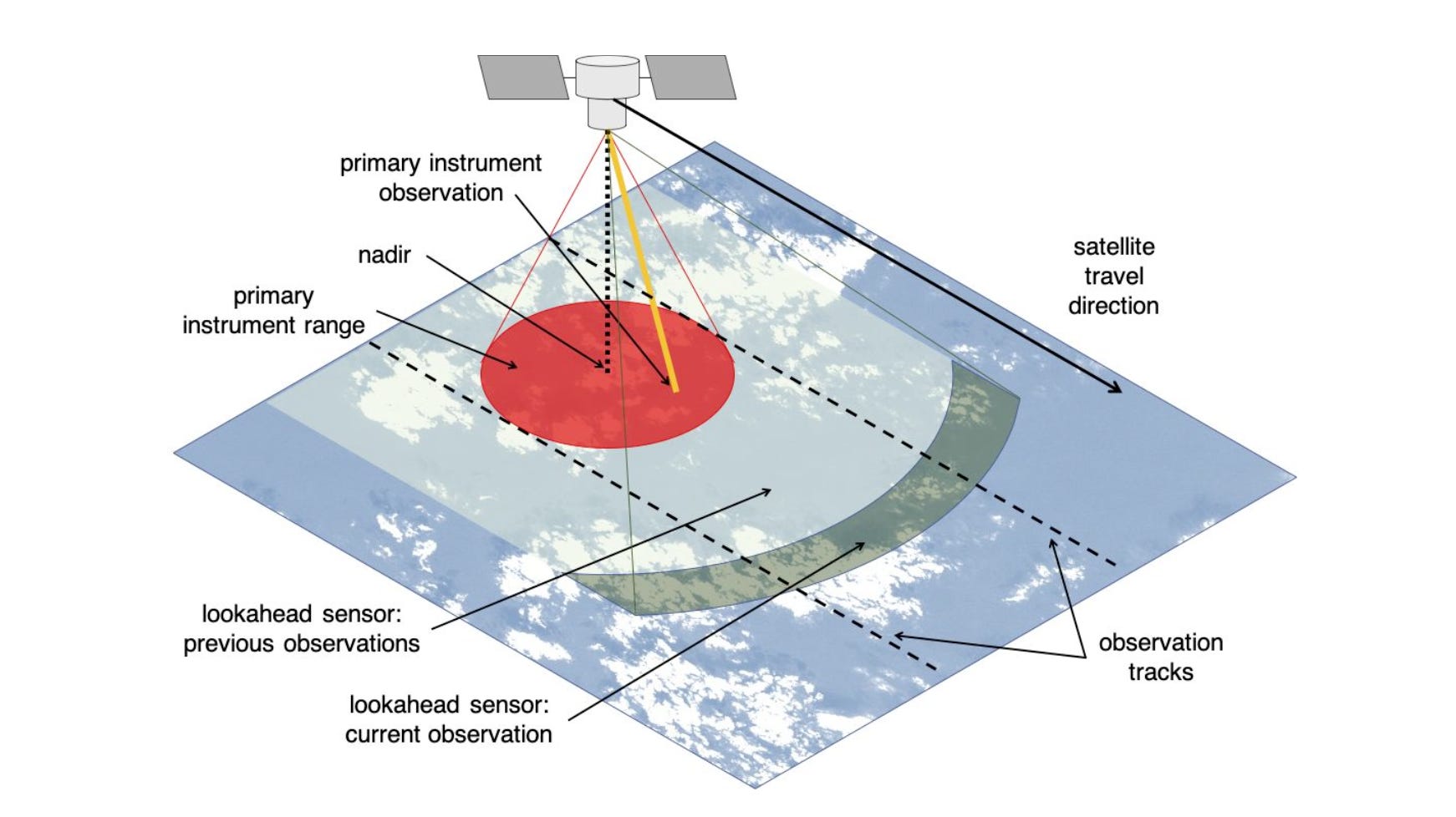
How NASA Is Testing AI to Make Earth-Observing Satellites Smarter [link]
"A technology called Dynamic Targeting could enable spacecraft to decide, autonomously and within seconds, where to best make science observations from orbit.
In a recent test, NASA showed how artificial intelligence-based technology could help orbiting spacecraft provide more targeted and valuable science data. The technology enabled an Earth-observing satellite for the first time to look ahead along its orbital path, rapidly process and analyze imagery with onboard AI, and determine where to point an instrument. The whole process took less than 90 seconds, without any human involvement."

Inside ICEYE’s Flood Watch From Orbit [link]
"The deadly waters rushing down the Guadalupe River in Texas this month had first responders deploying helicopters, boats — and SAR satellites.
ICEYE, the Finnish space radar operator, mapped nearly 100 square miles for FEMA as the disaster unfolded. The company’s goal was to help search and rescue workers understand the extent of the deluge. ICEYE’s data will be used by insurance companies and banks in an effort to speed up the recovery process. "

CAMS tracks intense global wildfire activity in first six months of 2025 [link]
"The first half of 2025 was marked by intense wildfire activity in several areas around the world. From the boreal forests of Canada and Russia to the agricultural heartlands of Southeast Asia, and from temperate zones of Europe to the Korean Peninsula, wildfires and the resulting long-distance transport of smoke had significant impacts on air quality. The Copernicus Atmosphere Monitoring Service (CAMS) has been tracking these global wildfires and monitoring the atmospheric impact in the affected regions and beyond. In this Observer, we look at some of the most significant wildfire activity in the first six months of the year, with a particular focus on two regions: North America and South and Southeast Asia."
Learning
Breaking Earth Observation Barriers: From Data Silos to Intelligent, Reliable Discovery | Element 84
"Jason Gilman presented at the Geo-AI Working Group on May 28, 2025.
Jason is Element 84's AI/ML Application Lead and a Principal Software Engineer with 20 years of experience in geospatial and Earth Observation.
Some of the key takeaways from Jason's presentation includes:
Understanding EO Barriers: Understand why challenges like finding relevant datasets or downloading large files are still an issue despite technological advances.
The Power of Foundation Model Embeddings: Learn why vector embeddings from foundation models represent the future of satellite data catalogs, enabling revolutionary capabilities like similarity searches, change detection, and intuitive classification without specialized expertise.
Building Trust in Geospatial AI: Explore proven techniques for developing reliable, explainable natural language systems that can answer complex questions about our planet while providing transparent reasoning and accountable results."
Presentation: [link]
Big fan of the newsletter, thanks for reposting my post!! It made my day.