


Watch live: Living Planet Symposium 2025 [link]
"One of the biggest Earth observation conferences in the world will take place next week in Vienna. You can watch streamed plenary discussions and presentations each day on ESA Web TV.
ESA’s Living Planet Symposium will be held in the Austrian capital from 23 to 27 June.
The themes for the week are summarised in the symposium’s strapline “from observation to climate action and sustainability for Earth”. There will be discussions on how we can work together in the fields of Earth science and with the Earth observation industry to promote effective climate action to address the environmental crisis, with presentations also on new trends in Earth observation.
As many as 6000 participants are expected from up to 119 countries, including at least 800 members of the scientific community.
The event is organised with the support of the Austrian Research Promotion Agency and Austria’s Federal Ministry of Climate Action, Environment, Energy, Mobility, Innovation and Technology. It will be held at the Austria Centre Vienna.
Watch the sessions live on ESA Web TV."
Level-2 News
Planet Hits Free Cash Milestone [link]
"Planet reported positive free cash flow—$8M—for the first time as a public company in its first quarter earnings release on June 4."
Remote Sensing CEOs Call Out Risks of Potential Budget Cuts [link]
"A group remote sensing CEOs outlined the risks that come with potential budget cuts to commercial imagery programs in a letter to Congressional leaders."
BlackSky to Expand Constellation With Multispectral, Large-Area Satellites [link]
"BlackSky is planning to expand the capabilities of its Earth Observation (EO) constellation with multispectral, large-area collection satellites called AROS, to launch “as early as 2027.”
BlackSky explained the AROS satellites are designed to support country scale digital mapping, navigation, maritime, and 3D digital twin applications. The company said the AROS plan has been in development for the past two years and was a key factor in the company’s move to acquire the full stake in its manufacturer, LeoStella late last year."
Planet Wins New NATO Intelligence Deal [link]
"Planet has signed a new seven-figure contract with NATO to deliver advanced daily monitoring and intelligence capabilities across NATO’s strategic areas of interest. Planet called it a “landmark partnership” and noted that it comes at a time of significant global change, and European nations are “rapidly enhancing their defense capabilities to address evolving geopolitical dynamics. Planet announced the deal on June 12. Financial terms were not disclosed."
Portuguese Air Force Taps ICEYE for SAR Satellite [link]
"ICEYE has made inroads into Portugal with a breakthrough SAR satellite deal. The Portuguese Air Force, a branch of the Portuguese Armed Forces is purchasing one ICEYE SAR satellite, a ground segment and an antenna. ICEYE will deliver the satellite and other components to CTI Aerospacial, a joint venture between the Portuguese Air Force and CEiiA, a local center of engineering and innovation. The parties are in discussions relating to the purchase of additional satellites in the future. ICEYE announced the deal, June 13."
BAE Systems and Hanwha Systems to Collaborate on Multi-Sensor Satellite System [link]
"BAE Systems and Hanwha Systems have signed a new MoU to develop a multi-sensor satellite system to collect radio frequency (RF) and synthetic aperture radar (SAR) data. "
Tomorrow.io Teams up with National Irrigational Administration for AI Weather Prediction Project in the Philippines [link]
"Low-Earth orbit satellite global weather intelligence provider Tomorrow.io will partner with the National Irrigation Administration (NIA) to help farmers adapt to climate change and boost productivity using Artificial Intelligence in the Philippines."
Iceye and IHI to Develop SAR Constellation in Japan [link]
"Iceye plans to develop a synthetic aperture radar (SAR) constellation with Japanese heavy industry company IHI Corporation under a new MoU announced Thursday. IHI and Iceye plan to establish a satellite manufacturing facility in Japan and develop a SAR constellation of up to 24 satellites."
Maxar partners with Array Labs to expand 3D imaging technology [link]
"Maxar Intelligence announced an agreement with radar imaging startup Array Labs to secure capacity on its constellation set to launch in 2026.
Array Labs, based in Palo Alto, California, is developing a 3D radar imaging constellation designed to operate in clusters, with swarms of small satellites working together to capture simultaneous images of the same location on Earth. Using synthetic aperture radar (SAR) sensors, Array Labs plans to capture high-resolution 3D imagery of the Earth regardless of lighting or weather conditions."
Marble Imaging starts developing easy access Earth Observation portal together with software company tenics [link]
"The "Dragoscope" project, which runs until the end of June 2026, will deliver the prototype for Marble's geospatial data portal "Kaleidoscope", allowing users to easily access public data as well as future Marble data and analytics.
The "Dragoscope" project is supported by a €450,000 grant from the development bank for Bremen and Bremerhaven (BAB)."
One ECMWF forum is now line! [link]
"The ECMWF forum was updated at the end of April 2025. It now has a fresh new 𝘭𝘰𝘰𝘬 and new categories and tags have been added to include all the latest exciting ECMWF products and services!
The forum is open to everyone and provides a platform for the ECMWF community to get involved in the latest discussions about ECMWF systems(e.g. AIFS, IFS and OpenIFS), services (e,g. DestinE and Copernicus) and data (e.g. Open Data, ERA5)."
Developer's Orbit
openEO by TiTiler: Open-Source Light and Fast Processing for Earth Observation [link]
"openEO by TiTiler has been officially released. This lightweight, high-performance backend implementation for openEO was developed through a collaboration between Development Seed and Sinergise, to provide a fast, open-source alternative for synchronous processing and visualization of Earth Observation data.
openEO by TiTiler is also deployed in CDSE, for the moment for demonstration purposes only. It is publicly available, allowing users to synchronously process and visualize Earth Observation data using the openEO API specification, with the speed and efficiency of the TiTiler engine."
Introducing Aurora: The first large-scale foundation model of the atmosphere [link]
"When Storm Ciarán battered northwestern Europe in November 2023, it left a trail of destruction. The low-pressure system associated with Storm Ciarán set new records for England, marking it as an exceptionally rare meteorological event. The storm’s intensity caught many off guard, exposing the limitations of current weather-prediction models and highlighting the need for more accurate forecasting in the face of climate change. As communities grappled with the aftermath, the urgent question arose: How can we better anticipate and prepare for such extreme weather events?
A recent study by Charlton-Perez et al. (2024) underscored the challenges faced by even the most advanced AI weather-prediction models in capturing the rapid intensification and peak wind speeds of Storm Ciarán. To help address those challenges, a team of Microsoft researchers developed Aurora, a cutting-edge AI foundation model that can extract valuable insights from vast amounts of atmospheric data. Aurora presents a new approach to weather forecasting that could transform our ability to predict and mitigate the impacts of extreme events—including being able to anticipate the dramatic escalation of an event like Storm Ciarán. "
Data

core-five: Multi-Modal Geospatial Dataset with Perfectly Harmonized Time & Space for Foundation Models [link]
"core-five is a pioneering dataset built for next-gen multi-modal vision models, unifying Earth Observation data from 5 essential sensors into perfectly aligned spatiotemporal datacubes.
Sentinel-2 (S2) – Optical, 10m resolution, 2-4 Months per cube
Sentinel-1 (S1) – Synthetic Aperture Radar (SAR), 2-4 Months per cube
MODIS – Daily environmental and land indicators, 2-4 Months per cube
Landsat-8/9 – Mid-res long-term optical data, 2-4 Months per cube
High-Resolution Imagery – 20-30cm GSD (Multiple Sources)
Each data sample is organized per S2Sphere Tile ID, with a 2-4 month temporal stack, enabling consistent cross-modality representation for foundational model training and temporal reasoning."
"With a size of 12 TB+ (growing), it stands among the largest datasets hosted on Hugging Face.
Designed for:
Pretraining large vision and multi-modal models
Cross-resolution & cross-sensor fusion
Spatio-temporal & vision-language learning"
Notebook [link]
LinkedIn Post [link]

Snapshots
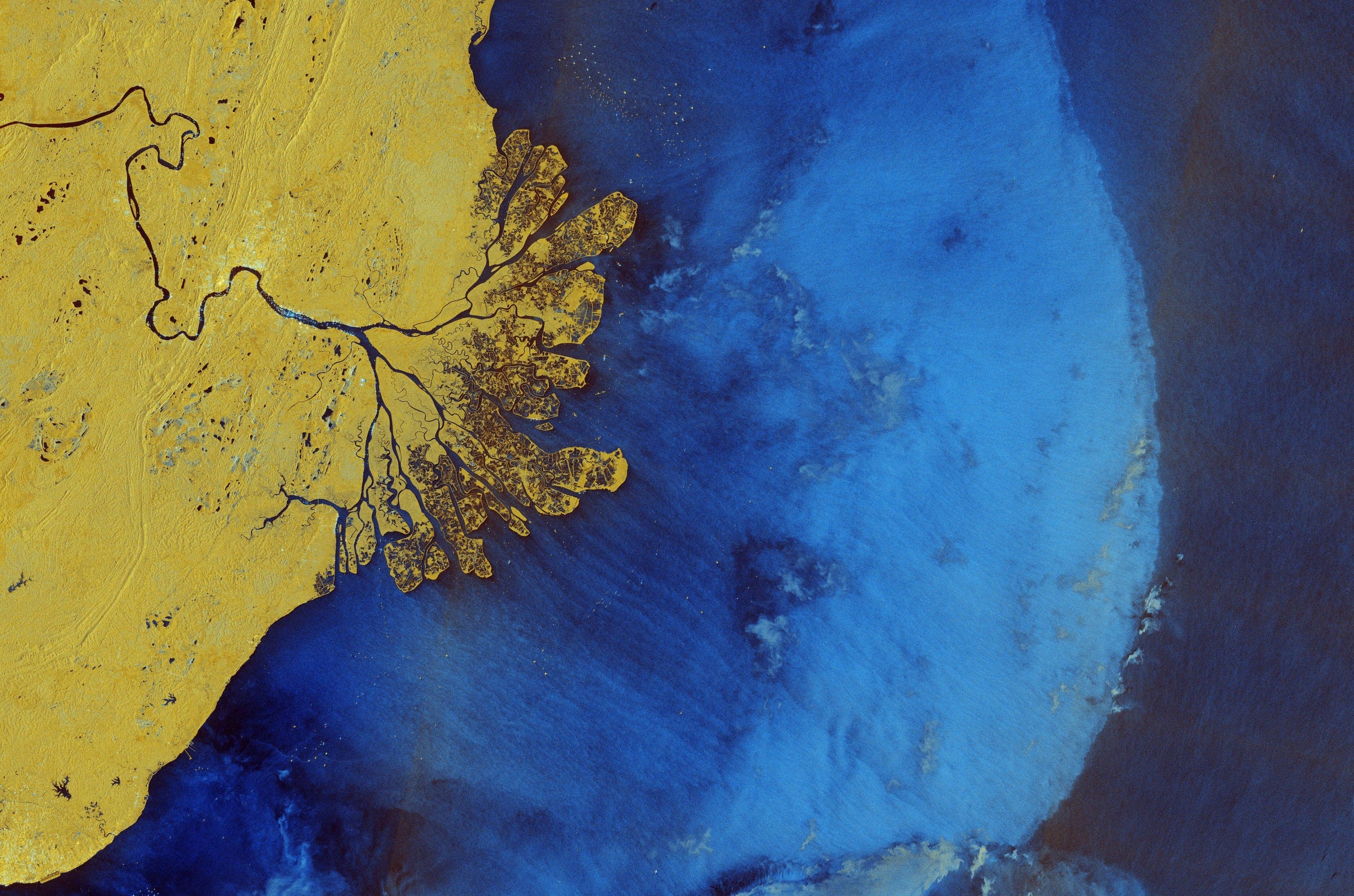
Earth from Space: East Kalimantan, Borneo [link]
"Borneo, the world’s third largest island, is shared between Brunei, Malaysia and Indonesia. The area pictured here covers part of the East Kalimantan province in Indonesia, with the Makassar Strait to the east, a narrow passage in the west-central Pacific Ocean.
This radar image is from 31 March 2025, it is in false-colour and in ‘dual polarisation’ horizontal and vertical radar pulses. Compared to a single acquisition, this dual mode provides more detailed and complementary information about Earth’s surface. Different colours represent different types of land cover, such as yellow for dense vegetation and forests and dark blue for water."
Interesting reads
Global Views of PACE Land Vegetation Data [link]
"Launched in early 2024, NASA’s new Plankton Aerosol Cloud ocean Ecosystem (PACE) satellite provides the world’s first and only hyperspectral, global coverage of terrestrial ecosystems every 1-2 days. Hyperspectral satellite observations such as these can allow us to detect vegetation characteristics such as concentrations of leaf pigments which play important roles in plant photosynthesis and protection, advancing our ability to understand and measure regional forest and crop health and productivity from space."
AI-Supported Sea Ice Mapping [link]
"Mapping sea ice is essential for ship traffic in the Baltic Sea. EOC's Maritime Security Lab in Bremen has developed an AI-supported approach that will now be employed by the Ice Service of the Federal Maritime and Hydrographic Agency of Germany (BSH)."
Air Quality Analysis: validating satellite data with ground measurements in Limassol, Cyprus [link]
Satellites offer a global view of air pollution, but struggle to capture the fine-scale, ground-level concentrations that impact our health most directly. Official, ground measuring stations provide exact values, but they are expensive and sparsely distributed. The AirTRack system, developed jointly by Augsburg University and the German Aerospace Center (DLR), bridges this gap with a dense network of calibrated, low-cost sensors measuring pollutants like NO₂, PM, and ozone in real time. Combined with satellite data, it enables a far more complete and actionable picture of urban air quality.
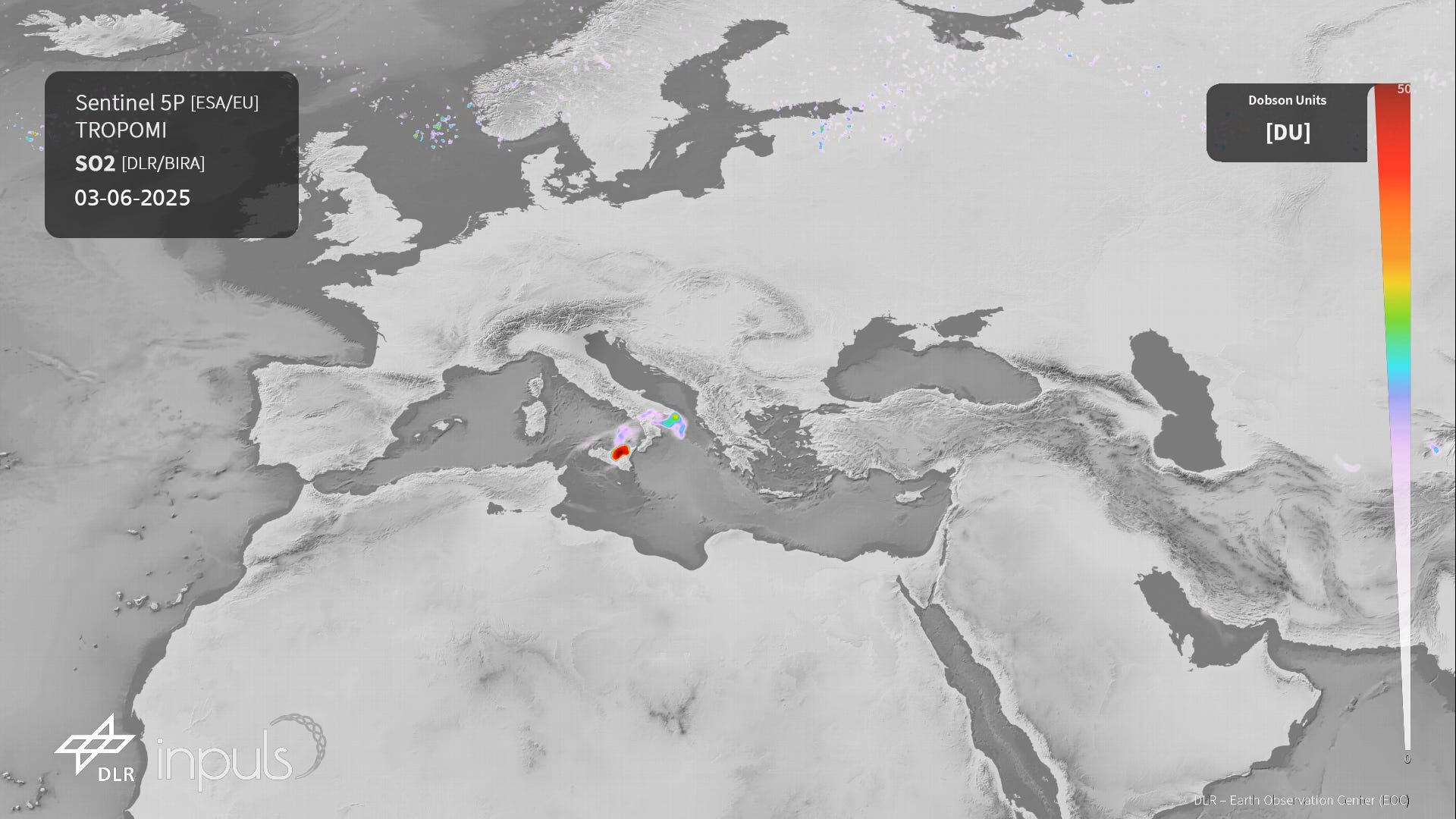
S5P measures SO2 cloud over Sicily [link]
"On Monday, June 2nd, at around 11:00 a.m. local time, Mount Etna in Sicily erupted with a massive explosion. Shortly after the eruption, the European satellite Sentinel-5 Precursor (S5P) detected the volcanic sulfur dioxide (SO₂) cloud over Sicily for the first time. Since then, operationally processed S5P measurements at the Earth Observation Center (EOC) have continuously recorded the development of the volcanic emissions."
Competitions

Classification for Landslide Detection [link]
"The objective of this challenge is to create a model that effectively leverages SAR for cloud-covered regions while prioritising optical data where available, enabling accurate and reliable landslide detection."
CLGE launches the Young Surveyors’ Contest 2025 [link]
"If you, or you and your teammates, are 35 years old or less and you have undertaken your thesis or some research work at a European university in the department of geodesy, cadastre, mapping or geoinformation or if you have a relevant project in mind, in one of these fields, you are welcome to participate in the CLGE Young Surveyors’ Contest 2025! You work must have been finalised within the last 3 years, i.e. between 1 January 2022 and 28 July 2025."
Submission Deadline: 28 July 2025, 23:00 CEST
Related:
Meet CLGE Ambassador Mar Roca Mora – from Contest Winner to marine earth observation doctoral researcher [link]
The HYPERVIEW2 Challenge is LIVE [link]
"KP Labs and the ESA’s Φ-Lab, together with Warsaw University of Technology and Poznan University of Technology rejoin forces for a second time: With HYPERVIEW2, the AI4EO Challenges return to AI-enhanced in-orbit processing to advance more efficient and sustainable farming."
Learning
GDAL CLI Modernization
"The GDAL Project Steering Committee was pleased to announce the release of GDAL 3.11.0 on May 9th, 2025. The 2024 GDAL User Survey [1] showed the GDAL Command Line Interface (CLI) to be in need of modernization, and GDAL 3.11.0 is the first release to provide a substantial refactoring of the common interaction point of many with the nearly 27 year old software project.
The new CLI, driven by sub-commands of the 'gdal' main program [2], is more convenient, consistent, predictable, and capable. It provides a GDAL spin on CLI concepts from rasterio, git, and others. Existing GDAL CLIs will continue to be supported as-is, but we hope the new CLI will make it easier to explore, learn, and reason about GDAL while manipulating geospatial data."
Reach out!
I'll be attending the Living Planet Symposium next week. Happy to chat over coffee (or beer / wiener schnitzel), if you're around!