

Applications for NASA DEVELOP are now open! [link]
"DEVELOP offers 10-week, paid, applied research opportunities for students, recent graduates, early or career-transitioning professionals, and military personnel and veterans. From September 15 – November 21, teams will work alongside science advisors to conduct feasibility studies that apply NASA Earth observation data to support partner organizations’ decisions.
Applications are due Friday, June 13."
Level-2 News
Outstanding Sentinel1C commissioning completed with successful IOCR [link]
"On May 7th, the latest member of ESA’s Sentinel1 — Sentinel-1C — was released into operations after successful completion of its In-Orbit Commissioning Review (IOCR) at ESTEC in the Netherlands."
Iceye Continues European Expansion With Rheinmetall JV and Manufacturing Center in Spain [link]
"Iceye has made key moves in Germany and Spain as it continues to grow its presence in Europe. In Germany, it has signed an MoU with German defense manufacturer Rheinmetall to establish a joint venture for satellite production. In addition, Iceye is also launching a new research & development and manufacturing center in Valencia, Spain."
Planet Signs 7-Figure Contract Expansion with the German Government, Enabling Land and Water Management from Space [link]
"Planet announced the German Federal Ministry of the Interior and Community (BMI) and the German Federal Agency for Cartography and Geodesy (BKG) have signed a seven-figure contract with Planet with a one year term and an option to renew for two more years.
The deal includes a fixed rate of all of Planet’s data products over Germany, including insights from Planetary Variables, water monitoring services from Planet’s partner EOMAP and access to Planet’s Insights Platform. This data will inform a variety of use cases, including monitoring water, forests, agriculture, socio-economics, and land-use, and support federal monitoring campaigns and environmental assessments."
OroraTech Joins Forces with SkyFi to Expand US Access to Space-Based Fire Detection [link]
"SkyFi and OroraTech have entered into a strategic partnership to bring space-based thermal monitoring and wildfire detection to a broader US audience through SkyFi’s Earth intelligence platform."
OroraTech Readies for US Expansion with New Denver Headquarters [link]
"OroraTech is hoping to make its presence felt in the U.S. market after opening its U.S. headquarters in Denver. The company, whic is based in Germany and specializes in wildfire intelligence and risk assessment, hopes to support wildfire resilience in the United Sates. The Denver office will serve as a central hub connecting U.S. wildfire emergency services, utility providers and government agencies with OroraTech’s space technology. OroraTech announced the move, April 24."
IonQ to acquire Capella Space in bid to build ultra-secure quantum network [link]
"IonQ, a Maryland-based quantum computing company, announced May 7 it has reached an agreement to acquire Capella Space, the first U.S. firm to launch a commercial radar imaging satellite."
UP42 and Maxar Partner to Broaden Global Access to the Most Advanced Commercial Geospatial Intelligence [link]
"UP42 has partnered with Maxar to make Maxar’s very high-resolution satellite imagery and tasking products available in the UP42 platform. UP42 customers can now directly task Maxar’s very high-resolution constellation, including its WorldView Legion satellites."
Developer's Orbit
From Access to Application: EOPF Sentinel Zarr Samples Webinars
Webinar 1: A new framework for data processing [link]
"The first webinar in this new series introduces a structured approach to adopting the EOPF Zarr data format, catering to a broad spectrum of users. It provides an in-depth exploration of the EOPF Sentinel Zarr Samples, outlining their core functionalities, advantages, and potential applications in data processing and analysis. The session includes a detailed walkthrough of the format’s structure and capabilities, highlighting how it facilitates more efficient data access and storage.The second part of the webinar is a live tutorial utilising Jupyter notebooks, offering participants a practical demonstration of how to work with the EOPF Sentinel Zarr Samples. This hands-on segment provides step-by-step guidance on accessing, manipulating, and analysing the data within this framework, showcasing best practices and useful techniques for seamless integration into existing workflows."
Webinar 2: Hands on with Sentinel 2 L2A EOPF Zarr [link]
"This webinar is a hands-on introduction to working with Sentinel-2 L2A data in the EOPF Zarr format, aimed at users interested in more efficient ways to access and work with Earth observation data."

Right-sizing STAC [link]
"Most cloud-native Earth data platforms rely on powerful infrastructure to deliver metadata search at scale. Development Seed is exploring how to make geospatial metadata more portable, efficient, and cost-effective by combining the flexibility of STAC with the lightweight power of GeoParquet."
Zarr + STAC [link]
"As part of Element84's work writing a STAC + Zarr Report for the Cloud Optimized Geospatial Formats Guide their team is exploring the partially overlapping goals of STAC and Zarr and offering suggestions for how to use them together. This effort is particularly relevant currently due to several recent developments in the space that they discuss later in this post."
OpenAerialMap v2: Faster, Better Imagery Access for Humanitarian Mapping [link]
"OpenAerialMap is evolving to provide faster, more reliable access to satellite and drone imagery for humanitarian mapping. With a new STAC-based infrastructure and modern tools, HOT and Development Seed are rebuilding OAM to meet today’s urgent mapping needs. Discover how this upgrade will improve interoperability, speed, and usability for disaster response and recovery efforts."
OpenPV - Open-source PV forecasts throughout Germany [link]
"The openpv.de website provides users with a comprehensive understanding of solar energy potential of their building. By utilizing openly available 3D building data, socalled LOD2 data, openpv.de offers an accurate representation of how solar energy can be harnessed both on roofs and facades."
Data
 to red (high)")
Sea Surface Salinity Datasets Now Available on the SNWG Earthdata Search Portal [link]
As part of the Satellite Needs Working Group (SNWG)’s Sea Surface Salinity (SSS) with Sea Ice Mask solution, three products were recently added to the SNWG Earthdata Search Portal:
Remote Sensing Systems (RSS) Soil Moisture Active Passive (SMAP) Level 3 Sea Surface Salinity Standard Mapped Image 8-Day Running Mean V5.0 Validated Dataset
RSS SMAP Level 2C Sea Surface Salinity Near Real-Time (NRT) V5.0 Validated Dataset
RSS SMAP Level 3 Sea Surface Salinity Standard Mapped Image 8-Day Running Mean V5.3 Evaluation Dataset
These products help address the need for low-latency measurements of sea surface salinity near the sea-ice edge, a gap identified during the SNWG 2020 assessment.
ALOS-2 ScanSAR Data Now Available in Earthdata [link]
"NASA has released a powerful, high-resolution radar dataset that is useful for studying Earth in extraordinary detail and compatible with measurements from upcoming missions.
The Alaska Satellite Facility Distributed Active Archive Center (ASF DAAC), in partnership with the Japan Aerospace Exploration Agency (JAXA), recently began publishing a synthetic aperture radar (SAR) dataset mirrored from JAXA's Advanced Land Observing Satellite-2 (ALOS-2) archive: the ALOS-2 PALSAR-2 Level 1 ScanSAR product.
The Earth observation data from ALOS-2 began in 2014 and are appropriate for many types of surveys, including ice sheet and landscape topography, vegetation analysis, geodynamic measurements, and disaster response. Earthdata’s first available ALOS-2 ScanSAR imagery covers North and South America and selected additional regions worldwide.
What’s more, ALOS-2 uses an L-band radar similar to the one that will be launched aboard the upcoming NASA/Indian Space Research Organization (ISRO) SAR (NISAR) mission, making data from the platforms scientifically compatible with each other."

Snapshots
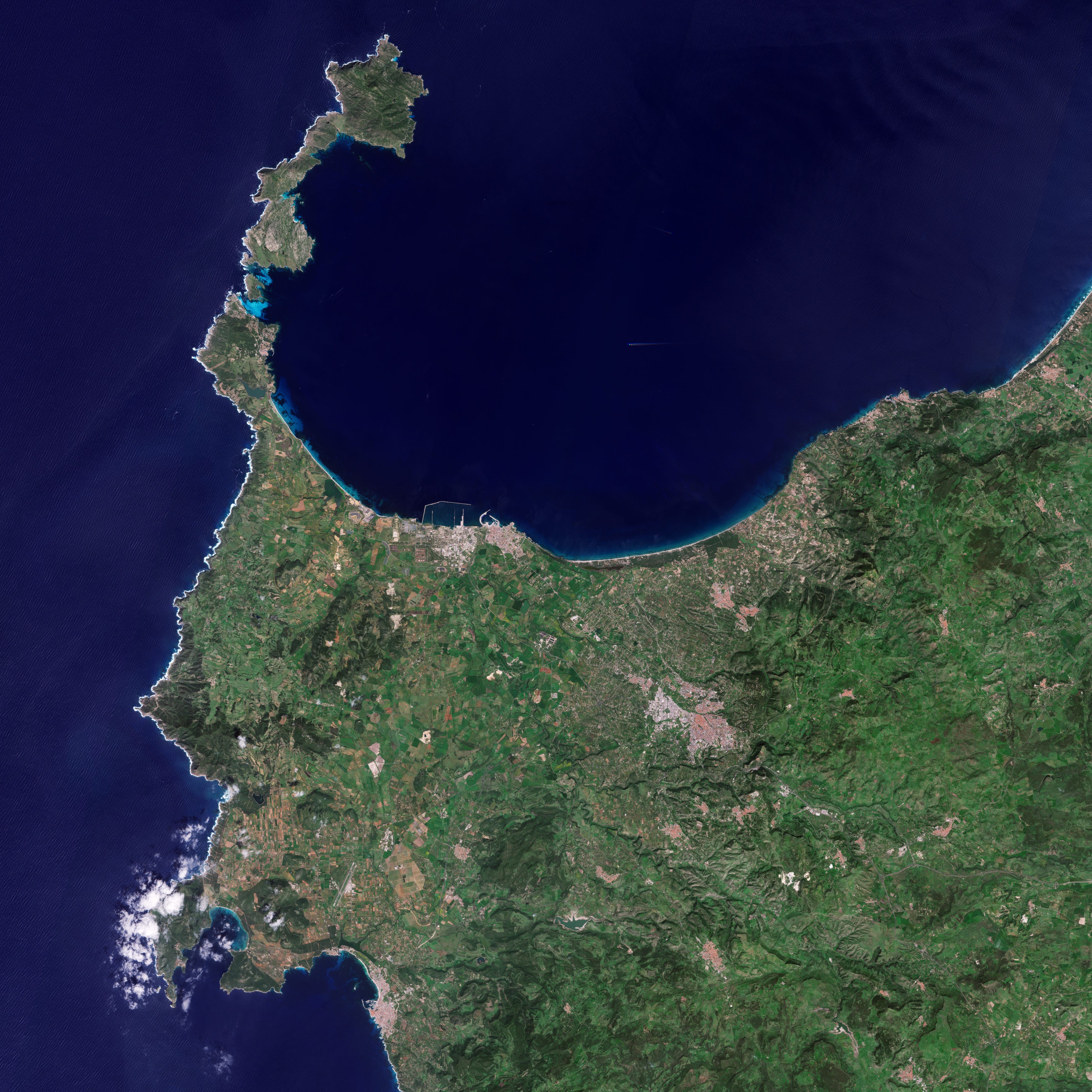
Earth from Space: Northwest Sardinia, Italy [link]
"With an area of about 24 090 sq km, Sardinia is the second-largest island in the Mediterranean Sea, after Sicily. It is situated about 200 km west of the Italian peninsula, a similar distance north of Tunisia, and is separated from the French island of Corsica by just 12 km."
Interesting reads
Why is Space-Based Decision Making so Hard to Do? [link]
Cassidy Rankine unpacks why using satellite observations to drive business and management decisions is difficult and it all comes down to uncertainty.
Confidence needs accumulation: One observation often isn’t enough—repeated captures reduce uncertainty and increase decision confidence.
Observation ≠ information: Frequency of information required and the frequency of observation are two very different things. It’s not about many images—it's about confidence in the composite.
Spectral data is noisy: Real-world spectral curves are impacted by ~400 km of atmosphere and sensor limitations, making interpretation challenging.
Ground validation is critical: Without in-situ references, satellite-derived insights risk losing/limiting accuracy.
Nation at a Crossroads: FY2026 Budget Proposal Threatens to Dismantle U.S. Geospatial Supremacy, Risking Economic and Infrastructural Integrity [link]
A 22.6% slash to non-defense federal funding in the proposed FY2026 U.S. budget could devastate the geospatial and Earth observation ecosystem. Over $3 billion in proposed cuts directly target:
NOAA: $1.5B+ cuts jeopardize climate, weather, and satellite data streams vital to agricultural technology, coastal management solutions, insurance modeling, and logistics.
NASA Earth Science: $1.16B cut undermines Landsat Next and global EO continuity.
USGS: $564M cut threatens core mapping, 3DEP, hydrography, and climate/ecosystem data.
This isn’t just a budget—it’s a potential unraveling of the U.S. geospatial enterprise.

How Earth observation satellite operators are teaming up to tip and cue one another [link]
"When imagery from the Worldview Legion satellites revealed fabric over a large object near a dry dock in North Korea in September, satellite operator Maxar Intelligence knew they needed help. They turned to Umbra Space, a company that focuses on synthetic-aperture radar imagery, for follow up. Umbra’s sensors are not obstructed by clouds, darkness or even thin fabrics. And so after tasking a satellite on orbit, Umbra’s team ultimately revealed what was under the netting: the outline of a submarine."
Climate
New version of the Copernicus Interactive Climate Atlas dataset and viewer [link]
"ECMWF announced that the new version (v2) of the Copernicus Interactive Climate Atlas (C3S Atlas) dataset and viewer has been published on 07-05-2025."
New C3S Atlas User Tools are also available [link]
Copernicus Interactive Climate Atlas Viewer [link]
LinkedIn Highlights
"What do geospatial tools and music editing software have in common?" [link]
Have a look at this post by Anthony Boyd, Product Manager at Development Seed. Apparently, when the company built the Exploration and Analysis tool for the VEDA Dashboard, they borrowed an idea from… Music editing software!
"As a scientist, there is always this one question on my mind; how much of what we do, actually reaches out to the public?" [link]
Not exactly related to usual content of this newsletter, but I found it really interesting. In this post, Kyriaki Kalimeri, researcher at the ISI Foundation, writes about their study "The role of science in the climate change discussions on Reddit" and their key findings.
Upcoming Events
Kickstart your Earth Observation journey with WEkEO’s Beginner-Friendly Webinar Series “WEkEO Essentials” [link]
"This spring, WEkEO is launching WEkEO Essentials, a three-part webinar series designed to empower newcomers in the Earth Observation community. Whether you are a student, an early-career professional, or simply curious about exploring environmental data, this series offers an inspiring, accessible entry point.
Through these sessions, participants will gain practical insights into working with atmosphere, climate, land, and ocean data – and by the end, they will have a solid understanding of the full range of WEkEO’s tools and how to apply them effectively in research and projects."
Geospatial Information Services in Support of United Nations Operations [link]
"This webinar will explore how GIS and Remote Sensing are transforming UN operations—supporting data-driven decisions in some of the world’s most challenging contexts"
Date & Time: 15 May | 16:30–17:15 CET
GeoBeer #49 [link]
"GeoBeer 49 will take place on the evening of 12 June (from 18:15) in Stadt St.Gallen. They have an exciting program with lightning talks, among others by Gjore Milevski of Development Seed about "Beyond the raw data – Building open science interfaces for Earth Observation"."
Learning
Cubes & Clouds 2.0 is out! [link]
The new version of the MOOC Cubes & Clouds is available again with plenty of new things to learn!
The new version includes content and exercises with the Pangeo ecosystem, a new lecture named Formats & Performance including an exercise measuring your algorithm energy consumption, parallel processing and chunking strategies.
All the course content is also available on GitHub for free.