

Living Planet Symposium - Registration is Open [link]
The event will take place on 23–27 June 2025 in Vienna, Austria and the deadline to register is 26 May.

Biomass mission – measuring Earth's 'lung capacity' from space [link]
"Forests cover 40.6 million square kilometres of our planet – almost a third of Earth' s ice-free land area. Often called the 'green lungs' of our planet, they supply our atmosphere with fresh oxygen. But how healthy is this vital organ of our Earth? Can it continue supplying us with enough fresh air to keep Earth's ecosystems functioning? To answer these questions, we must first determine the lung capacity of our forests.
This is the task of the Biomass mission, which is scheduled to launch on 29 April 2025 on a Vega-C rocket from Europe's Spaceport in Kourou, French Guiana."
Level-2 News
Up to 15 Greek satellites set for launch within two years [link]
"Between 10 and 15 Greek satellites are expected to be launched into orbit over the next two years by the Ministry of Digital Governance in collaboration with the Hellenic Space Center. These satellites are being developed by Greek companies that have taken advantage of government incentives and have established operations within Greece."
Geopera Partners with Wyvern [link]
"Geopera has partnered with Wyvern, adding high-resolution hyperspectral satellite imagery to their data offerings for the Australian market. This collaboration enables their customers to access Wyvern’s Dragonette constellation data directly through the Pera Portal, providing new analytical capabilities for various applications specific to Australian environments and industries."
Planet Signs Three-Year Contract with EMDYN, Providing Satellite Data for Intelligence, Insurance, and Security Solutions [link]
"Planet announced a multi-year contract with EMDYN, a European-based company providing agile intelligence-led solutions and security services.
Through this relationship, EMDYN will use Planet’s near-daily global satellite imagery and taskable high resolution SkySat satellites to monitor subtle activity across large geographical regions—such as border movements, infrastructure development, or maritime patterns—and capture fleeting, high-resolution imagery of events as they unfold."
OroraTech opens US office to expand wildfire monitoring network [link]
"German satellite operator OroraTech opened its U.S. headquarters in Denver, Colorado, April 24 to push its growing wildfire-monitoring constellation into a country that regularly experiences some of the world’s most costly fires.
The seven-year-old startup said the office will be a central hub for connecting U.S. emergency services, utility providers and government agencies with its wildfire mapping and analysis platform.
Leveraging a proprietary network of 10 heat-tracking cubesats in low Earth orbit, along with public data from more than 30 satellites in LEO and geostationary orbit, OroraTech says its services can significantly improve response capabilities once a fire breaks out."
Umbra to develop maritime surveillance satellites for U.S. military [link]
"Umbra, a California-based manufacturer of synthetic aperture radar (SAR) satellites, has been tapped to develop next-generation sensor satellites aimed at enhancing maritime and open-ocean search capabilities for the United States and its allies in the Indo-Pacific.
The company was selected to develop these satellites under a public-private agreement known as Strategic Funding Increase (STRATFI) that could be valued at up to $60 million pending final contracting and co-investment commitments."
To build new weather satellite instruments, L3Harris opts for automated manufacturing [link]
"L3Harris Technologies is preparing to modernize the development, production and testing of weather satellite instruments in a new 9,290-square-meter facility in Fort Wayne, Indiana."
Poland Invests in 3-Satellite EO Constellation Built by Creotech Instruments [link]
"Polish space company Creotech Instruments will build three Earth observation (EO) satellites for Poland under a new contract with the European Space Agency (ESA) announced April 15. The contract is worth nearly 52 million euros ($59 million) and the project is named CAMILA, Country Awareness Mission in Land Analysis.
Poland’s Ministry of Development and Technology ordered the national satellite constellation.
Creotech Instruments is the prime contractor of the system, which will consist of three observation satellites and a ground segment. The three satellites will feature different sensors — one radar, one high-resolution optical and one lower-resolution optical, and the contract includes options for a potential fourth satellite."
Sidus Space, Little Place Labs Unveil New Maritime Intelligence Capabilities for the LizzieSat Platform [link]
"Sidus Space rolled out near real-time vessel detection and classification capabilities for its LizzieSat space-based maritime intelligence satellite platform.
Sidus’ 3D printed LizzieSat can now process data directly onboard through its Orlaith AI Ecosystem, which includes its FeatherEdge edge computing hardware, and OrbitfyEdge software from its tech partner Little Place Labs.
This solution not only detects and classifies vessels but also cross-references onboard AIS (automatic identification system) data to identify or flag “dark” vessels engaged in illegal activities such as piracy or illegal fishing."
Developer's Orbit
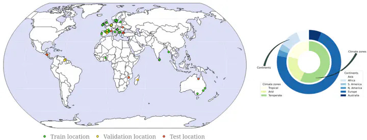
Data-Centric Methods for Satellite Image Segmentation [link]
"This repository contains implementations of data-centric approaches for improving semantic segmentation performance on satellite imagery. These methods won the MVEO data-centric competition.
The authors share the implementation of techniques for prioritizing training samples based on different measures:
Diversity-based selection: Prioritizing samples that represent the diversity of the dataset
Complexity-based ranking: Focusing on samples with higher information content
The main dataset supported is DFC-22, with additional experimental support for Potsdam and Vaihingen datasets."
GeoDeep's AI Detection on Maxar's Satellite Imagery [link]
"Follow this post by Mark Litwintschik as he runs some of GeoDeep's built-in AI models on Maxar's satellite imagery of Myanmar and Bangkok, Thailand."
Data
Kuro Siwo: A global multi-temporal SAR dataset for rapid flood mapping [link]
43 global events manually annotated
338B m² of land mapped
33B m² flooded zones & water bodies
Dual SAR:
GRD (optimised)
SLC (raw for complex-valued ML)
Self-supervised ready: large unlabelled SAR with consistent preprocessing
Benchmarked with BlackBench
Related:
Code and data for Kuro Siwo flood mapping dataset [link]
Kuro Siwo: 12.1 billion m² under the water. A global multi-temporal satellite dataset for rapid flood mapping [link]
Wyverns updated theirs Open Data Program [link]
Wyverns announced that they updated their Open Data Program with a new version of their imagery, version 1.4, featuring several improvements to data access!
The'll also be releasing some additional imagery soon.

Snapshots

"You're not looking at shipping data. You're looking at air pollution." [link]
Check out this LinkedIn post by Diana Urge-Vorsatz.
"This image shows global shipping routes, visualised not through vessel trackers—but through NO₂ pollution emitted by ships, captured via satellite.
Thanks to ESA's Sentinel-5P, scientists can now also detect pollution from individual ships from space! The result: shipping lanes appear as atmospheric scars across the oceans.
Shipping is a major but often overlooked source of nitrogen dioxide, contributing to both climate change and regional air pollution. And as trade patterns shift—due to market, geopolitical, or regulatory factors—these atmospheric signatures may shift too.
It's a striking example of how economic activity, policy, and pollution are deeply intertwined—and visible from space."
Explore the visualization: [link]
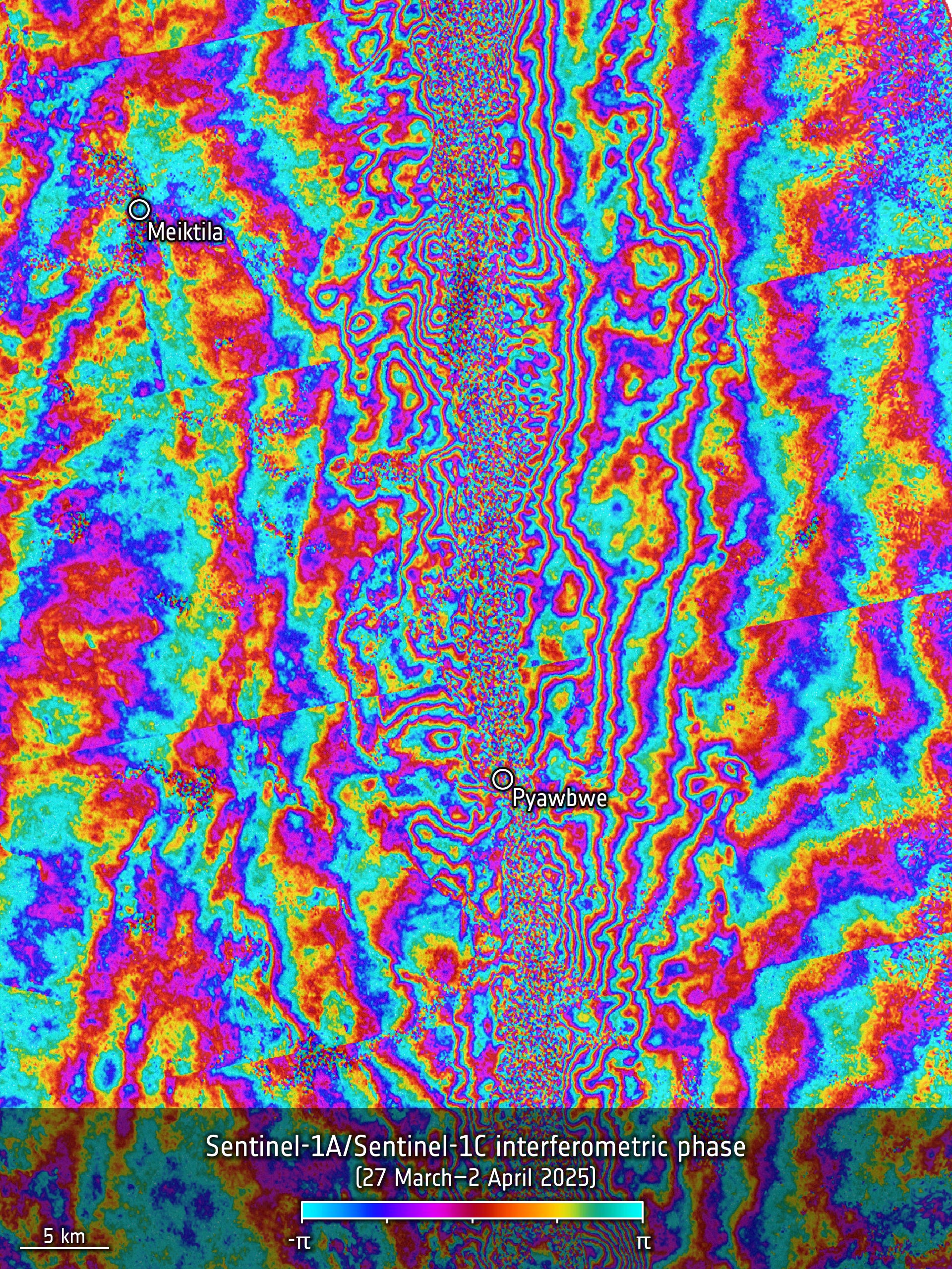
Sentinel-1 captures ground shift from Myanmar earthquake [link]
"On 28 March 2025, a powerful magnitude 7.7 earthquake struck central Myanmar, sending shockwaves through the region. While the country is still dealing with the devasting aftermath, scientists have used radar images from the Copernicus Sentinel-1 satellites to reveal a detailed picture of how the ground shifted as a result of the quake – offering new insights into the mechanics of the tectonic Sagaing Fault and the scale of the seismic rupture."
Interesting reads
NASA Measures Moonlight to Improve Earth Observations [link]
"Flying high above the clouds and moon-gazing may sound like a scene from a timeless romance, but NASA did just that in the name of Earth science research. In March 2025 pilots took the agency’s ER-2 science aircraft on a series of night flights over NASA’s Armstrong Flight Research Center in Edwards, California, as the Moon increased in visible size. For those few nights, the high-flying plane was converted into a one-of-a-kind airborne lunar observatory.
The Airborne Lunar Spectral Irradiance, or air-LUSI, mission observed the Moon at different phases and measured the sunlight reflected by the lunar surface. Specifically, the instrument tracks the amount of light reflected at different wavelengths. This information enables scientists to use the Moon as a calibration tool for Earth-observing sensors."
Climate
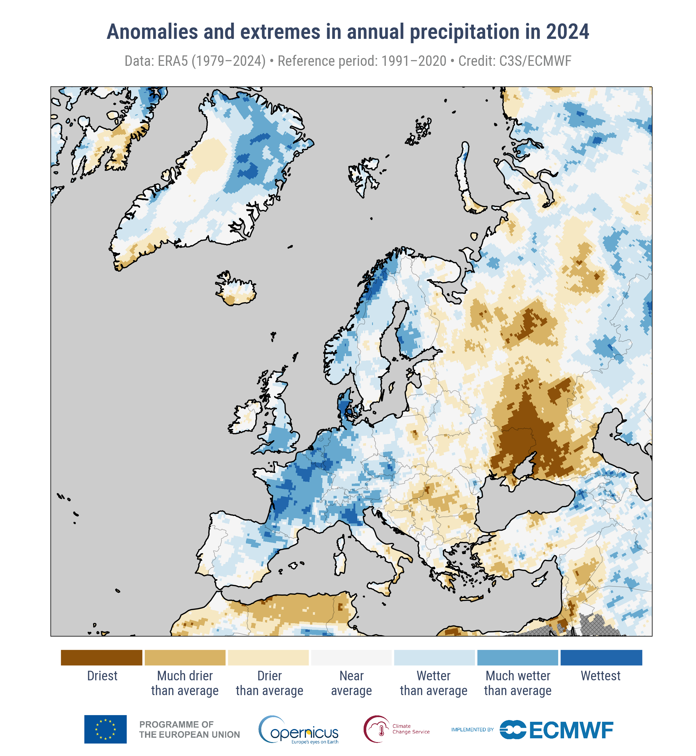
The ESOTC2024 report reveals a distinct east-west contrast in precipitation across Europe last year [link]
"In 2024, Europe experienced above-average precipitation overall, with around 34% of the land area seeing above-average annual precipitation.
There was a pronounced east-west contrast in conditions. Western Europe saw widespread wetter-than-average conditions, with some areas in a swathe from Spain and Italy to northern Fennoscandia experiencing their wettest year in the period since 1979. For western Europe, excluding Iceland, it was one of the ten wettest years in the analysed period since 1950.
Across most of eastern Europe, conditions were drier than average, with eastern Ukraine and parts of southwestern Russia having their driest year in the period since 1979."
Related:
Europe’s Warmest Year on Record—Striking Climate Contrasts in 2024 [link]
"The European State of the Climate 2024 (ESOTC 2024) report, jointly published on 15 April by the Copernicus Climate Change Service (C3S) and the World Meteorological Organization (WMO), reveals that 2024 was the warmest year, both for Europe and globally, since records began. Across the continent, people experienced dramatic and contrasting climate conditions. While the east faced dry, scorching heat, the west endured heavy rainfall and flooding, marking a year of profound and disruptive climate extremes."
LinkedIn Highlights
"Open data doesn’t reach its full value until someone can explore it, share it, and understand it." [link]
Check out Anthony Boyd's post on the importance of building open-source tools that enable scientists to share their stories.
Related:
VEDA Dashboard: https://www.earthdata.nasa.gov/dashboard/
VEDA Documentation: https://docs.openveda.cloud/
Development Seed's explanation of the project: https://developmentseed.org/projects/nasa-impact-veda/
Call for Papers
TerraBytes is now accepting proceedings [link]
"At the intersection of data curation, data archiving, and representation learning, this workshop will foster a holistic discussion covering major steps in the EO from downlinked satellite data, training paradigms to downstream applications."
TerraBytes is a ICML 2025 Workshop - 18/19 July 2025 - Vancouver, Canada.
Papers submission deadline: May 16th, 2025
Competitions
SpaceNet 9: Cross-Modal Satellite Imagery Registration [link]
SpaceNet is an initiative dedicated to accelerating open-source, artificial intelligence applied research for geospatial applications, specifically foundational mapping (i.e., building footprint and road network detection). SpaceNet is run by co-founder Maxar and partners Amazon Web Services (AWS), Topcoder, Oak Ridge National Laboratory, Umbra, and IEEE GRSS.
Participants in this challenge will develop algorithms to compute pixel-wise spatial transformations between optical imagery and SAR imagery, specifically in earthquake-affected regions. These algorithms will be evaluated for their ability to align tie-points across modalities, enabling better downstream analytics such as damage assessment and change detection.
To support the competition, the challenge provides a dataset consisting of high-resolution optical imagery from the Maxar Open Data Program and SAR imagery from UMBRA. The dataset includes manually labeled tie-points to evaluate registration quality. A baseline algorithm is also provided to set a performance benchmark, but participants are encouraged to explore novel approaches to significantly improve accuracy.
See this paper written by the SpaceNet team for more details.
Learning
How to make an animated map of the 2024 North Atlantic Spring Phytoplankton Bloom map using QGIS, Adobe Illustrator, and Adobe Premiere [link]
Follow this tutorial by Chiara Phillips, on how to create an an animated map of the 2024 North Atlantic Spring Phytoplankton Bloom map using QGIS, Adobe Illustrator, and Adobe Premiere. The tutorial was part of the recent Copernicus Marine Service Data Viz Webinar Series.
Reach out!
I'll be attending the ESA–NASA International Workshop on AI Foundation Models for Earth Observation in Frascati, Italy. Happy to chat over coffee (or tiramisu) if you're around!