

A year of weather 2024
EUMETSAT released its 2024 weather visualisation, revisiting key weather events of last year on a global scale.
Level-2 News
D-Orbit Acquires Italian EO Company Planetek [link]
"Space logistics company D-Orbit announced a deal on Friday to acquire Italian Earth Observation (EO) and analytics company Planetek Group to bring together in-orbit servicing and space data.
D-Orbit has acquired all of Planetek’s shares. D-Orbit said the two companies will retain operational autonomy, but will “explore new innovative business models and synergies” together. "
New contract signed for continued development of CLCplus Core [link]
"The Copernicus Land Monitoring Service (CLMS) announced the signing of a new contract designed to support the ongoing development and operation of the CLCplus Core platform—an integral component of the expanding CLCplus product suite."
ESA’s Arctic Weather Satellite hailed as excellent [link]
"Launched just seven months ago, ESA’s Arctic Weather Satellite has been proving how the New Space approach can accelerate the development of missions capable of delivering detailed temperature and humidity profiles for short-term weather forecasts.
Moreover, the impact of this tiny prototype satellite goes even further – its measuring instrument has been recognised as able to provide data that’s on a par with traditional large missions."
Biomass cleared for fuelling [link]
"Since its arrival at Europe’s Spaceport in French Guiana three weeks ago, ESA’s Biomass satellite has been under the scrutiny of satellite engineers who have been carefully executing the long list of tasks on the ‘to do’ list to make this new Earth Explorer mission ready for liftoff on 29 April. The latest milestone passed, is that Biomass’ propulsion subsystem has been prepared for fuelling and has undergone thorough system checks."
Developer's Orbit
"Find me all the log yards in Europe" [link]
"Check out this demo, by Samuel Barrett, using pre-computed EO embeddings (from Clay's foundational model on NAIP imagery), to rapidly identify log yards across Washington and Oregon."
GitHub Repo [link]
Earth Observation Training Data Lab (EOTDL) [link]
"Co-funded by ESA Φ-lab, EOTDL is a new repository for finding high-quality and curated training datasets for all your Earth Observation, AI, deep learning, and machine learning needs."
Copernicus Data Space Ecosystem releases new STAC Catalog [link]
"The Copernicus Data Space Ecosystem has launched a new STAC Catalog, improving access to Sentinel-2 cloudless mosaics & Sentinel-1 GRD datasets."
Fundamentals: Tensors vs. Tables [link]
This post by Earthmover breaks down - from first principles - why cloud-native, array-first systems are essential for geospatial, AI, and any data with shape, space, or time.
Streaming satellite imagery into QGIS using STAC and Cloud-Optimised GeoTIFFs [link]
"This post demonstrates how to search a STAC Catalog for Sentinel-2 and Landsat imagery, access their COG assets and programmatically build a QGIS project that streams false-colour composites - no (persistent) download required."
Data
GAIA: A Global, Multi-modal, Multi-scale Vision-Language Dataset for Remote Sensing Image Analysis [link]
"GAIA is a large-scale vision-language dataset designed to bridge the gap between remote sensing (RS) imagery and natural language understanding. It provides 205,150 image-text pairs (41,030 images with 5 synthetic captions each) for advancing RS-specific vision-language models (VLMs). The dataset spans over 25 years of Earth observations (1998-2024), covering diverse geographic regions, satellite missions, and RS modalities."
Paper: GAIA: A Global, Multi-modal, Multi-scale Vision-Language Dataset for Remote Sensing Image Analysis [link]
New data set release: ATLAS/ICESat-2 L3A Along Track Coastal and Nearshore Bathymetry [link]
"ATLAS/ICESat-2 L3A Along Track Coastal and Nearshore Bathymetry, Version 1 is now available at the NASA National Snow and Ice Data Center Distributed Active Archive Center (NSIDC DAAC). This data set contains global along-track coastal and nearshore bathymetry, consisting of refraction-corrected seafloor and sea surface heights (orthometric and ellipsoidal heights and instantaneous depths), as well as associated uncertainties. The data are derived from ATLAS/ICESat-2 L2A Global Geolocated Photon Data (ATL03)."
Release of GEDI V2 Data for April through November 2024 [link]
"The LP DAAC is pleased to announce the availability of the Global Ecosystem Dynamics Investigation (GEDI) Version 2 Level 1B Geolocated Waveform Data, Level 2A Elevation and Height Metrics Data, and Level 2B Canopy Cover and Vertical Profile Metrics Data for April 27, 2024 through November 28, 2024."
Retirement of the Land Cover Viewer application [link]
"The Land Cover Viewer Application was retired on April 1, 2025. Its core functionality has been integrated into the CLMS portal."

Snapshots
Major thunderstorms in Spain as seen by EarthCARE’s Broadband Radiometer [link]
"Spain and Portugal have witnessed particularly high rainfall throughout late winter and early Spring, and the European Space Agency’s Earth Cloud, Aerosol and Radiation Explorer (EarthCARE) has captured some of the weather systems causing it."
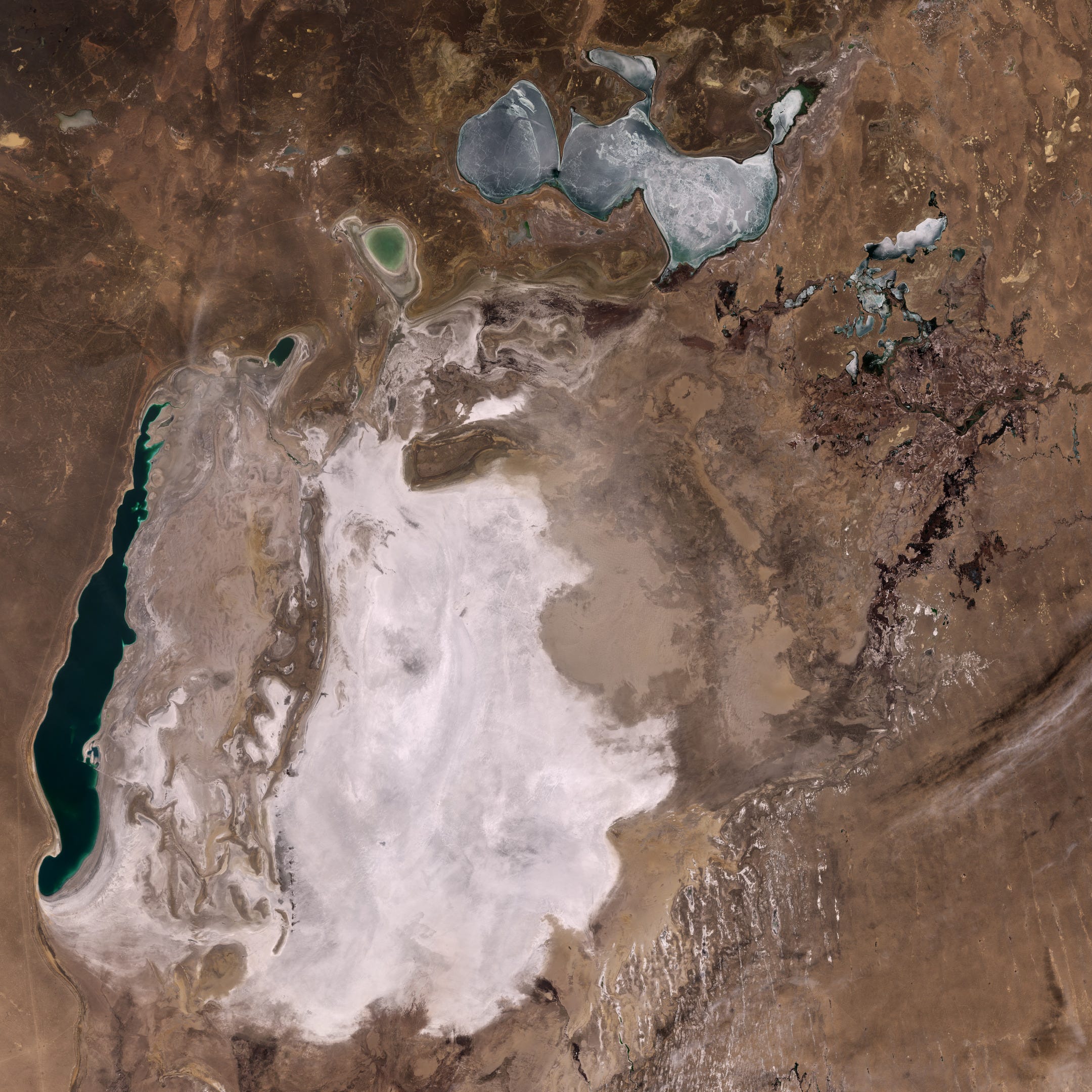
Earth from Space: The shrinking Aral Sea [link]
"Straddling the border between Kazakhstan in the north and Uzbekistan in the south, the Aral Sea was once a large inland water body in Central Asia. In 1960, the lake covered an area of about 68 000 sq km – twice the size of Belgium."
Interesting reads
The State of EO 2025 [link]
"Payload talked with senior officials from HawkEye 360, ICEYE US, Maxar Intelligence, Planet, Umbra, Albedo, Wyvern, and Capella about the state of the EO industry and how companies are driving toward profitability."
With satellites built and launched, the Earth Observation industry is now being tested on the value its data can deliver.
Key Highlights:
Beyond Launch: Demonstrating Real-World Use:
The EO sector has entered a critical phase - moving beyond satellite launches to monetizing the data and proving its real-world value.Unlocking EO Data with AI:
AI is accelerating delivery and democratizing access to EO data, but it’s not a silver bullet—complex use cases still demand significant effort and expert-driven workflows.Defense Still Dominates:
National security agencies remain EO’s primary customers, but there's growing interest from foreign governments seeking sovereign constellations.Commercial Potential Awaits:
Opportunities exist in industries like forestry, oil spill detection, and infrastructure - but EO must prove it can outperform drones or aircraft.Multiphenomenology Fusion:
Combining SAR, hyperspectral, high-res optical, and public datasets is seen as a major growth area.Export Challenges:
U.S. firms are hindered by export controls (e.g., ITAR), giving non-U.S. SAR providers a competitive edge in sovereign satellite deals.
IRIDE: A satellite with a unique background [link]
Follow this article by Josef Aschbacher as he shares the first images from the IRIDE constellation, marking the beginning of a new era for optical multispectral imagery from satellites entirely designed and integrated in Italy.
As Wildfires Raged, Satellite Imagery and GIS Helped Fill In Information Gaps [link]
By the end of January, California was already facing one of its worst fire seasons ever. As the Palisades and Eaton Fires tore through Los Angeles County, ICEYE’s smoke-penetrating radar satellites and Esri’s GIS dashboards gave first responders the data they needed.
AI and satellites help aid workers respond to Myanmar earthquake damage [link]
A news item covering the satellite imagery tool created by teams at Planet & Microsoft AI for Good Lab for the Myanmar earthquake.
"The analysis shows 515 buildings in Mandalay with 80% to 100% damage, +1,524 with between 20% and 80% damage. Pinpoints locations of damage for teams on the ground."
Microsoft AI for Good - Building damage visualizer [link]
Production of the national Italian land cover and land use map [link]
Italy’s national LCLU map shows how Copernicus data can power country-specific solutions - offering a model for land monitoring across Europe.
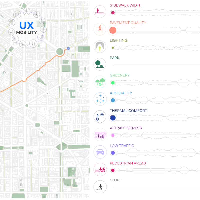
UX Mobility: Multi-User Walkability Route Planner [link]
"Recognizing the diversity of urban characteristics, street design, possible routes and user types, the research focuses on assessing the level of walkability in the city of Milan (Italy) according to the unique experiences and needs of different users. The aim is to provide valuable information for urban planners and policy makers, and to promote the analysis of more inclusive and adaptive urban environments that improve the quality of life for multiple urban users."
Podcasts
Mitigating Methane Emissions at CarbonMapper with Dr. Dan Cusworth [link]
"New Carbon Sense podcast episode from LumenUs Scientific! Dr. Daniel Cusworth and Dr. Sean Crowell dive into how Carbon Mapper uses remote sensing to detect, quantify and pinpoint methane super-emitters — and why public data is key to mitigation action."
LinkedIn Highlights
"The map isn't the thing. The data is the thing." [link]
Deepfake from Above: When Satellites Start Spreading Lies [link]
Upcoming Events
EarthCODE Workshop at FOSS4G 2025 14th/15th of July 2025 [link]
"EarthCODE is set to take the stage at FOSS4G 2025 with an interactive workshop!"
FOSS4G Workshop Schedule [link]
CDSE Webinar: Advanced Use of Copernicus Browser [link]
"This webinar will introduce you to advanced visualization and data analysis in Copernicus Browser."
8 April 2025
14:00 CEST (12:00 UTC)
New PACE *Terrestrial* Data Users’ Group [link]
"We are excited to announce the formation of the PACE Land data Users' Group! NASA's PACE satellite now provides novel hyperspectral and polarimetric data products that have exciting potential for the terrestrial remote sensing community. This group provides a forum to build community around, and capacity for, terrestrial science and applications with PACE data. Anyone currently using - or interested in - PACE's land data products is encouraged to join our kickoff meeting to learn more!"
Tuesday April 15th, 2pm-3pm (Eastern US, UTC-4:00)
Open Roles
Job Openings at Hydrosat [US-Remote, Luxembourg-On-site] [link]
AI Product Manager at Maxar [US-Remote] [link]
Senior Project Manager & Account Manager (Geospatial) at Sparkgeo [Remote] [link]
Geospatial Developer at Global Maritime [UK (Newcastle / Aberdeen / Glasgow / London)] [link]