

Level-2 News

Planet Labs PBC Releases Images From Pelican-2 [link]
"Planet released first light images from its Pelican-2 satellite of the Port of Laem Chabang in Eastern Thailand, the primary deep sea port in Thailand. They were taken on March 12, 2025, from an altitude of around 506 km. Pelican-2 launched on SpaceX’s Transporter-12 Rideshare mission on January 14, 2025."
Planet Labs Signs Contract with ESA to Support Greek National Space Services [link]
"Planet Labs signed a contract with the European Space Agency (ESA) on behalf of the Hellenic Ministry of Digital Governance to support the Greek National SmallSat Program, Planet announced on March 24."
Iceye Provides SAR Satellite Data to NATO Situation Center [link]
"Iceye announced it will provide satellite data to the Situation Center at NATO HQ (SITCEN). The collaboration will give SITCEN access to Iceye’s capabilities, which Iceye said will enhance its ability to deliver data-driven assessments to decision-makers."
OroraTech to Integrate Thermal Data to NVIDIA Earth-2 Digital Twin Platform for Extreme Weather Event Prediction [link]
"OroraTech is adopting NVIDIA Earth-2 digital twin platform, providing real-time thermal data to enhance extreme weather and climate event predictions."
Synspective Signs Rideshare Launch Contract with SpaceX for Launch of StriX Satellites [link]
"Synspective Inc., a provider of Synthetic Aperture Radar (SAR) satellite data and analytics solutions, announced that it has signed a contract with SpaceX for the launch of two Synspective StriX satellites on a rideshare mission target for 2027.
Synspective plans an ambitious 30 SAR satellite constellation deployment by the late 2020s to remain at the forefront of the satellite imaging industry."
Planet Expands Strategic Partnership with SynMax, Offering Customers AI-Enhanced Vessel Identification, Classification, and Smart Surveillance Capabilities [link]
"Planet announced that they have expanded into a new strategic partnership agreement with SynMax, a Houston-based satellite analytics and intelligence company. This marks an evolution in Planet’s previously announced partnership with SynMax, providing data for energy industry intelligence and dark/spoofing vessel tracking."
Carbon Mapper Selected for California Satellite Data Purchase Program [link]
"The non-profit organization Carbon Mapper and its partner Planet Labs PBC announced that they will be working with the State of California through the Satellite Data Purchase Program, helping the State leverage remote sensing technology to reduce methane emissions and tackle climate change.
Developer's Orbit
Solving NASA's Cloud Data Dilemma: How Icechunk Revolutionizes Earth Data Access [link]
"NASA has been migrating over 100 petabytes of data from on prem systems to the cloud for the last several years and is now able to focus on measures of efficiency that were not possible before. Earthmover and Development Seed worked with NASA to pilot Earthmover’s open-source Icechunk tensor storage engine to optimize cloud-native data access for level 3 datasets on top of existing archival files without a costly and complex data migration. When applied to the popular GPM IMERG precipitation dataset, this technology enabled a 100x speedup for extracting time series data compared to existing approaches for the same task, while also simplifying the end-user experience."
OGC looks to adopt openEO as Community Standard; Seeking Public Comment before moving to vote [link]
"OGC seeks public comment on adopting openEO API & Processes as Community Standards to unify cloud-based Earth observation data processing. Comments due April 21, 2025."
Meta’s Adoption of Overture Maps: A Case Study [link]
"Meta, one of the founding members of Overture Maps Foundation, has successfully transitioned its suite of global basemaps used across apps such as Facebook and Instagram to Overture’s base data layers, demonstrating the power and potential of open, interoperable map data. This case study explores the background, benefits, and future implications of this significant shift."
IBM Research just released TerraTorch v1.0 [link]
"After six months of work, IBM Research just released TerraTorch v1.0 – a PyTorch Lightning-based framework designed to simplify fine-tuning and benchmarking of Geospatial Foundation Models."
Techical Report: TerraTorch: The Geospatial Foundation Models Toolkit [link]
TerraTorch on Github [link]
source-coop: Unofficial Python SDK and CLI for Source Coop [link]

Snapshots

IRIDE first image presented at ESA–ESRIN [link]
"The first image from a new Italian Earth observation satellite mission was published this week: a high-resolution image of a strip of the Italian peninsular showing the city of Rome at a resolution of 2.66 metres. This is three times higher than the resolution currently available for systematic acquisition over Italy."
Climate
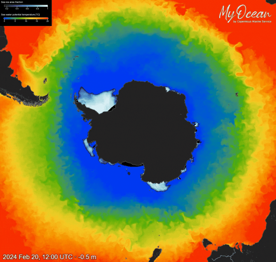
Antarctic Sea Ice Reaches Near-Record Low in 2025 [link]
"On 25 February 2025, the Antarctic sea ice reached its minimum extent for the year, covering 1.87 million km2, according to Copernicus Marine data. This marks the seventh lowest minimum extent on record, tied with 2024, which is 8% below the 1993–2010 long-term average."
State of the Global Climate 2024 [link]
The World Meteorological Organization releashed the State of the Global Climate 2024 report.
"2024 was the warmest year in the 175-year observational record."
"Key messages
Key climate change indicators again reach record levels
Long-term warming (averaged over decades) remains below 1.5°C
Sea-level rise and ocean warming irreversible for hundreds of years
Record greenhouse gas concentrations combined with El Niño and other factors to drive 2024 record heat
Early warnings and climate services are vital to protect communities and economies"
Interesting reads
A Powerhouse of Global Satellite Infrastructure: Norway? [link]
Sarah Scoles explores Norway's critical role in global satellite operations - NOAA, NASA, and USGS and other operators depend on its ground stations. The article traces this strategic importance from the 1960s to the upcoming Landsat Next missions, touching on the growing geopolitical concerns along the way.

Global Renewables Watch - a Living Atlas of the World’s Renewable Energy - is Now Live to the Public [link]
"The Global Renewables Watch, a first-of-its-kind living atlas mapping and measuring utility-scale solar and wind installations across the Earth, is now live to the public! First announced in 2022, this collaborative initiative between Planet, Microsoft, and The Nature Conservancy (TNC) was made possible by combining Planet’s satellite data, Microsoft’s advanced AI technology, and TNC’s renewable energy subject matter expertise."
Related:
Here’s What the Rise of Clean Energy Looks Like From Space [link]
Follow this piece from The New York Times that covers the Global Renewables Watch.
Podcasts
Thermal Lens: Understanding Uncertainties in Land Surface Temperature (LST) [link]
"This episode of "Thermal Lens" features Dr. Claire Bulgin, a Senior Research Scientist in Earth Observation at the University of Reading.
Claire takes us into the often-overlooked world of uncertainties in land surface temperature (LST) measurements and elaborates on the differences between error and uncertainty, the roles of accuracy, precision, and bias, and the challenges of calculating and communicating uncertainties. Claire breaks down how current satellite missions address these issues, the common sources of uncertainty, and what goes into building reliable uncertainty budgets."
EUMETSAT's Forecasting Innovation podcast series [link]
"In a new podcast series “Forecasting Innovation”, EUMETSAT's Chief Scientist Paolo Ruti shares knowledge with a broader audience and foster discussion on technical innovations at EUMETSAT and its partner organisations."
LinkedIn Highlights

"As scientific institutions face defunding and political pressures, how do we ensure global data infrastructure remains resilient?" [link]

"It’s the least popular time to start a satellite imagery company in the last 15 years." [link]
Upcoming Events
Marine Data 4 Sustainable Oceans 2025 [link]
"The Copernicus Marine Service is hosting a two-day online workshop dedicated to harnessing marine data for a sustainable future of our oceans.
The event will explore key oceanic phenomena, with a focus on sustainable ocean use across various sectors. Topics will include wind energy, oil spills, navigation routes, and others.
April 8th & April 10th
Laser Altimetry Applications for a Changing World: Working with ICESat-2 Bathymetry Data [link]
"In this webinar, we will cover a new global ICESat-2 bathymetric data product, ATL24, including results of an ATL24 accuracy test. We will then present use cases, including training models for extracting bathymetry from multispectral imagery and identifying hazards to marine navigation. We will also demonstrate a public web application programming interface (API) for processing ICESat-2 data in the cloud."
Apr 09, 2025 2:00 PM ET
TerraBytes - Towards global datasets and models for Earth Observation - ICML 2025 Workshop [link]
TerraBytes is a workshop exploring the unique challenges of Earth Observation (EO) data in machine learning. It focuses on creating better datasets, improving learning methods, and applying them to real-world problems like disasters, land use, and climate monitoring.
Papers submission deadline: May 16th
Open Roles
Cartography Internship at the Woodwell Climate Research Center [Falmouth, Massachusetts] [link]
Several Openings at Planet [link]
Senior Earth Observation Expert at Starion [Frascati, Italy] [link]
Senior Geospatial Software Engineer at Perennial [link]
Learning
Dataviz Webinar Series - Replays & PDF Presentations [link]
"Discover how to turn ocean data into compelling visual stories with the Dataviz Webinar Series, hosted by the Copernicus Marine Service and Mercator Ocean international.
Featuring three renowned keynote speakers from the data visualization community, this series focuses on bridging the gap between science and society by making complex Copernicus Marine data accessible and visually engaging."
WEkEO 4 Atmosphere Monitoring - Replays and Presentations [link]
"The Copernicus WEkEO Service organized a two-day workshop to increase user awareness of the atmopsheric environment, related issues and conservation techniques specific to this subject.
The aim of this workshop was to share applications of the Copernicus WEkEO Service products in ecosystem monitoring studies and to focus on the main challenges faced by the atmosphere .
The workshop covered a number of related topics, ranging from air quality, wildfires, heat waves and precipitations."
That renewables web map is interesting. I'd just read an article about how much new capacity there has been in the last few years. Renewables are almost half all installed power capicity already, which is mind-blowing, in large part due to China. https://cleantechnica.com/2025/03/26/92-5-of-new-power-capacity-added-worldwide-in-2024-was-from-renewables/