

Level-2 New
Sentinel-2A: Extended Campaign Starting March 13, 2025 [link]
"The Sentinel-2A extended campaign will begin on March 13, 2025, for a period of one year.
This exceptional campaign will temporarily complement the nominal constellation operations with Sentinel-2B and Sentinel-2C, enhancing the capabilities of the Sentinel-2 Mission, providing greater benefits to both operational and scientific user communities."
ECMWF’s AI forecasts become operational [link]
"ECMWF has taken the Artificial Intelligence Forecasting System (AIFS) into operations on 25 February 2025, to run side by side with its traditional physics-based Integrated Forecasting System (IFS) to advance numerical weather prediction.
The AIFS outperforms state-of-the-art physics-based models for many measures, including tropical cyclone tracks, with gains of up to 20%.
This high-accuracy model complements the portfolio of our physics-based models by leveraging the opportunities made available by machine learning (ML) and artificial intelligence (AI). These include increased speed and a reduction of approximately 1,000 times in energy use for making a forecast.
The AIFS is the first fully operational weather prediction open model using machine learning with the widest range of parameters. It includes vital fields for users, such as wind and temperature, and details on precipitation types from snow to rain. The AIFS has a grid spacing of currently 28 km."
Related:
Weather forecasting takes big step forward with Europe’s new AI system [link]
DIU Awards BlackSky Tactical GEOINT Contract For Gen-3 Satellite [link]
"BlackSky Technology on Tuesday said that it won a “multimillion dollar” contract from the Defense Innovation Unit (DIU) to manage and operate one of the company’s Generation-3 Earth imaging satellites for the Tactical GEOINT (TACGEO) program."
Bayer Expands its License Agreement With Planet for Agricultural Data [link]
"Bayer has expanded its work with Planet in a multi-year enterprise license agreement for greater access to Planet’s satellite imagery for its agriculture products. Planet announced the deal on Feb. 25, financial terms were not disclosed.
Bayer has been a longtime customer of Planet. The expanded enterprise agreement will provide better access to Planet’s data and allow Bayer teams to integrate satellite insights into their workflows. It includes access to PlanetScope, Tasking, Fusion, Basemaps, and Planetary Variables."
Developer's Orbit
Release of the new CDSE STAC catalogue [link]
"A new prototype of the SpatioTemporal Asset Catalogue (STAC) of the Copernicus Data Space Ecosystem available under https://stac.dataspace.copernicus.eu/v1.
STAC promotes cloud-native access to data by providing a standardized way to catalog geospatial assets, offering several benefits that align well with cloud computing workflows. Using STAC provides a consistent way to describe geospatial assets, facilitating interoperability for discovery and access to heterogeneous datasets. It is designed to manage massive datasets, providing rich metadata that allows processing large amounts of data without needing to download all the raw assets.
Development of the new CDSE STAC was a joint effort of the CDSE consortium, European Space Agency with a large contribution from Matthias Mohr and Kamil Monicz. CDSE consortium is also grateful to the Development Seed for development and maintenance of the STAC API and pgSTAC backend."
Satellite-based wildfire monitoring in California using EO data on CREODIAS [link]
Check out this post by CREODIAS. "The code presented is designed for the visualization of areas experiencing active wildfires. It leverages satellite imagery from the Sentinel-2 mission to accurately identify and illustrate burned regions."
A Discourse Forum for the awesome gee-community-catalog.org [link]
Samapriya Roy kicked-off a Discourse Forum for the awesome gee-community-catalog.org.
"This new space is designed to spark conversations, share insights, and build collective knowledge around all things Google Earth Engine, datasets, tutorials, research, blogs, and more. It's a forum designed for the community based on community feedback."
Data
Satellogic EarthView Dataset Now Openly Accessible via Registry of Open Data on AWS [link]
"Satellogic announced that the Satellogic EarthView dataset is now openly accessible on Amazon Web Services (AWS) cloud through the AWS Open Data Sponsorship Program.
The Satellogic EarthView dataset includes over 2 million regions across five continents with multiple revisits, reaching in total over 7 million images. By having access to Satellogic EarthView on AWS, researchers AWS pay only for computing services they use without having to purchase extra storage. AWS, through its Open Data Sponsorship Program, is covering the costs of the storage and transfer of the data, so that it can be accessed and analyzed in the cloud by researchers around the world."

MyOcean Pro Viewer Update: In Situ Data and Streamline Visualisation [link]
The Copernicus Marine Service is to announced the latest update of the Copernicus Marine MyOcean Pro Viewer, released on 23 January 2025. This update introduces improved in situ data visualisation, marking a step forward in providing accessible and reliable tools for ocean monitoring.
Declassified Gallery [link]
"Over 350 historic declassified spy satellite images taken between 1960 and 1984 that have been georeferenced to allow for an easy browsing experience."
SoilSuite – Sentinel-2 – Europe, 5 year composite (2018-2022) [link]
"The SoilSuite contains a collection of different image data products that provide information about the spectral and statistical properties of European soils and other bare surfaces such as rocks. It is created using DLR's Soil Composite Mapping Processor (ScMAP), which utilises the Sentinel-2 data archive."
Method and data description [link]
Mapservice [link]

Snapshots
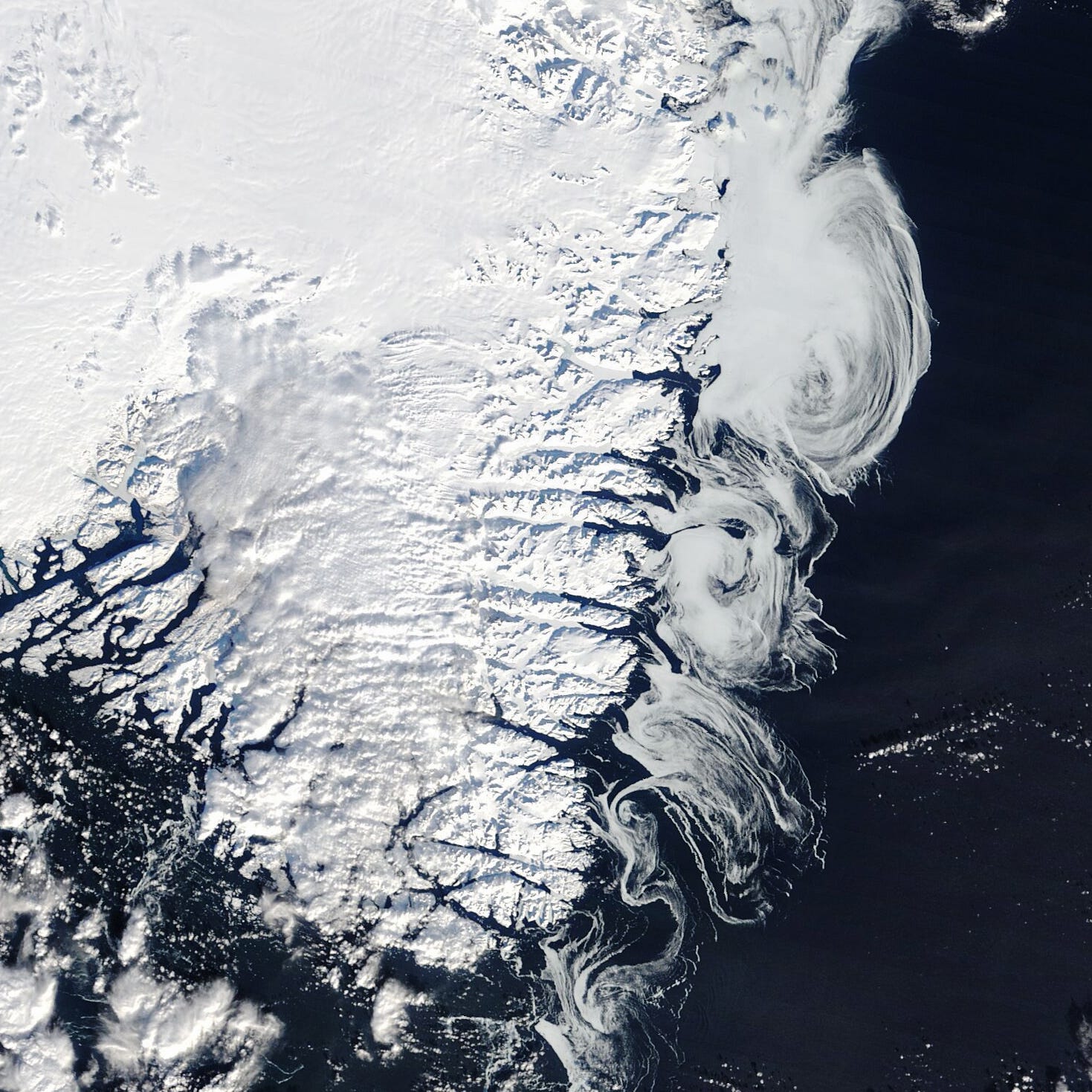
Whorls of White off Greenland [link]
"Greenland is an icy place year-round, but the winter months bring extra whorls of white. This satellite image, captured on February 24, 2025, shows the southern part of the island, from its snow-topped ice sheet and glaciers to the sea ice swirling along its coasts.
Seasonal snow gives the ice sheet a fresh white appearance. (Note that part of the ice sheet toward the south is covered by patchy clouds.) In contrast, melting in the summer months can expose dark-colored particles that have accumulated near the ice sheet’s perimeter, giving it a brown tinge."
Interesting reads

Optimizing Geospatial for the Cloud [link]
"Development Seed launched a Zine that highlights amazing Free and Open Source cloud-native geospatial tech."
New Satellite Constellation Companies are in Decline: Analysis [link]
"The number of new satellite constellation businesses has sharply declined over the past decade as the space market matures and new startups struggle to find angles to differentiate.
In 2024, only seven new constellation businesses (i.e., satcom, EO, and in-orbit inspection satellites) were founded globally, according to NewSpace.
In 2015, that number was 50."
Monitoring fire emissions and mitigating global impacts with CAMS [link]
"2024 saw South America in the grips of a wildfire crisis, with some countries and regions experiencing record-breaking emissions and severe air quality impacts, as highlighted in the annual wildfires review of the Copernicus Atmosphere Monitoring Service (CAMS). In addition to the destruction and tragic loss of life and biodiversity, wildfire smoke emissions significantly worsened air pollution in the affected regions and beyond, amplifying health risks and contributing to a rise in CO2 global emissions.
This week’s Observer explores CAMS data on the historic wildfires, their impact on air quality, and the critical role the service plays in monitoring emissions and smoke transport around the world."
Long-term changes to the Mekong River Delta and their impacts on the region’s food security [link]
"With a coastline stretching over 3000 kilometres and extensive aquatic resources, Vietnam is among the top 5 seafood export countries globally. The industry contributes to about 5% of the country’s Gross Domestic Product and 50% of the country’s marine fisheries are found in the Vietnamese Mekong Delta (VMD), making it a cornerstone of food supply.
Its long coastlines and low-lying coastal regions also mean that Vietnam is among the countries most exposed to coastal hazards intensified by climate change, which implies that the nation’s bustling seafood export industry is vulnerable—but how exactly?
A recent study led by Mr. Feng Yikang, a Research Associate at the Earth Observatory of Singapore working with the Tropical Rivers Group led by EOS Principal Investigator Edward Park and the Climate Transformation Programme, uncovered that the zone where the Mekong River meets the South China Sea, typically called a river plume, has shrunk since 2000. Published in the Journal of Hydrology, the study is the first long-term monitoring of the plume in the VMD and offers insights to its evolution due to human activities. "
Paper:
Severe decline in extent and seasonality of the Mekong plume after 2000 [link]
NASA Uses New Technology to Understand California Wildfires [link]
"Developed at NASA JPL, the science instrument gives researchers a more detailed picture of high-temperature surfaces, such as land scorched by wildfire, than previous infrared instruments."
Upcoming Events
C3S User engagement Workshop with the Alpine user community [link]
"The Copernicus Climate Change Service (C3S), with the support of the Alpine Convention, is organising an online workshop dedicated to the use of climate data and services in the Alpine region. The workshop will take place on Tuesday, 11th March 2025.
This half-day event is designed for scientists, policy officers, and practitioners who use or are interested in using C3S data for their work in the field of climate change."