

Level-2 News
Sentinel-1C demonstrates power to map land deformation [link]
"Launched just two months ago and still in the process of being commissioned for service, the Copernicus Sentinel-1C satellite is, remarkably, already showing how its radar data can be used to map the shape of Earth’s land surface with extreme precision.
These first cross-satellite ‘interferometry’ results assure its ability to monitor subsidence, uplift, glacier flow, and disasters such as landslides and earthquakes."
NASA Confirms Resignations Amid Workforce Cuts, DOGE Leadership Faces Scrutiny [link]
"Hundreds of NASA employees signed up for a voluntary resignation offer as the federal government continues cutting jobs nationwide, raising concerns about potential impacts on the space agency’s workforce."
Related:
Space Advocates Seek To Protect NASA Workforce [link]
India's space regulator launches $58 million fund to boost startups, cut reliance on imports [link]
"The Indian National Space Promotion and Authorisation Centre (IN-SPACe) on Wednesday launched a 5 billion rupee ($57.58 million) fund to help early-stage space technologies go commercial and reduce reliance on imports as the country seeks to boost its market share in the global space industry."
BlackSky’s Gen-3 Sat Enters Orbit, Company Lands String of Contracts [link]
"BlackSky launched its first Gen-3 Earth observation satellites aboard Rocket Lab’s Electron rocket, adding higher-resolution imaging to its data offerings.
The next-gen satellite offers 35-cm resolution imaging capability and will help improve automated detection and identification for the company’s Spectra AI-powered platform."
BlackSky to support India’s first private Earth observation constellation [link]
"BlackSky has been tapped to supply satellite imagery, analytics services, and a high-resolution optical satellite as part of a broader effort led by European aerospace firm Thales Alenia Space to develop a sovereign remote sensing constellation for India’s Nibe Ltd., a growing player in the country’s aerospace and defense industry."
SuperSharp Selects NanoAvionics’ Satellite Platform for Thermal Infrared Mission [link]
"SuperSharp, part of the Satlantis group, selected Kongsberg NanoAvionics‘ MP42 microsatellite platform for its thermal infrared mission, called Blue Moon.
Blue Moon will feature SuperSharp’s Hibiscus instrument, an 80 kg payload designed to capture long-wave infrared imagery. The instrument will help support applications in climate resilience and national security by providing day and night imaging capabilities.
The Blue Moon satellite is scheduled to launch in the second half of 2026 on a SpaceX Transporter rideshare service. The partnership between SuperSharp and NanoAvionics is supported by the UK Space Agency."
Space42 Forms JV to Boost EO Capabilities [link]
"Space42 has set out some ambitious plans in the Earth Observation (EO) arena. It is establishing a joint venture (JV) with Edge Group to develop a fully integrated EO ecosystem. The JV will be with FADA, an EDGE Group entity, established to develop the UAE’s sovereign space capabilities. The two companies announced the JV on Feb. 17.
The JV will serve as a central hub for manufacturing, deploying, and operating EO assets. By combining Space42’s space infrastructure and expertise in geospatial analytics and Artificial Intelligence with FADA’s leadership in advanced technology and defense, the planned JV will deliver dual-use EO capabilities tailored for both government and commercial applications."
Developer's Orbit
New Jupyter Notebook GitHub Repository Offers Tips and Scripts for Using NASA’s Atmospheric Data [link]
"NASA’s Atmospheric Science Data Center (ASDC) recently debuted its new GitHub online collaboration and code-sharing page offering tutorials, scripts, and guides for using data from a variety of sources such as the Tropospheric Emissions: Monitoring Pollution (TEMPO) instrument. The files available in the ASDC Data and User Services GitHub repository help users in working with ASDC-managed mission data for investigating atmospheric processes, air quality, and related science."
ASDC Data and User Services GitHub repository [link]
Data
The Harmonized Landsat Sentinel-2 Project Releases Vegetation Indices [link]
"NASA’s Harmonized Landsat and Sentinel-2 (HLS) project released two new products, the Landsat 30-meter Vegetation Index (HLSL30VI) and Sentinel-2 30-meter Vegetation Index (HLSSS30VI). Each product contains a suite of nine vegetation indices including greenness, vegetative moisture content, burned area, and vegetation change.
Users can access the HLSL30 and HLSS30 VI products through NASA’s Common Metadata Repository (CMR) and Earthdata Search. In addition, NASA's LP DAAC plans to integrate these products into the Application for Extracting and Exploring Analysis Ready Samples (AppEEARS) in early 2025."
30 m annual GLanCE land cover datasets for Oceania [link]
LP DAAC Announces the Addition of Oceania to the Global Land Cover Mapping and Estimation (GLanCE) Data Product [link]
Global Land Cover Estimation (GLanCE) on awesome-gee -community-catalog [link]

Snapshots

Planet Snapshots - Issue 159: Farewell! [link]
"Ryder Kimball, the creator and editor of Snapshots who, after an amazing 159 issues over 3.5 years, is taking off from Planet.
Snapshots was designed to help highlight satellite data’s societal transition from an arcane technology understood by the few to an easily-accessible dataset utilized by the many. If you learned a thing or two about the Earth Observation industry or how satellites work, then we succeeded. But the common heartbeat throughout each issue pulsed with a different beat: that the world is a fascinating place and worth exploring, understanding, and protecting."
I loved those Snapshots!
When Spectral Reflectance was published on Medium, I used to link those Snapshots (also published on Medium).
Follow Ryder Kimball on Substack, Uncharted
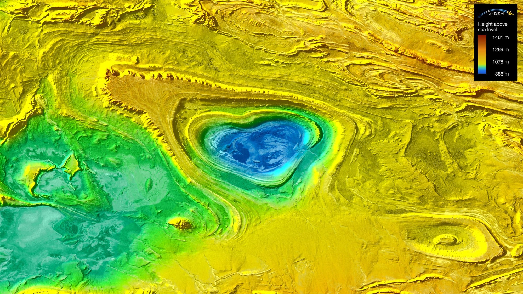
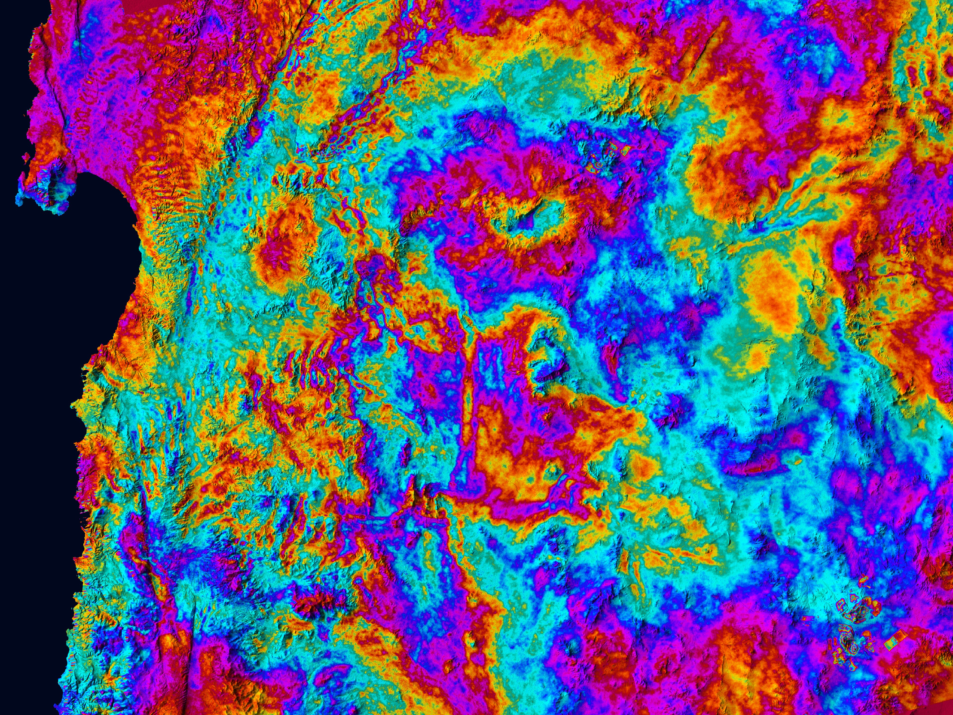
Valentine's Day greetings from TerraSAR-X and TanDEM-X [link]
"This Valentine's Day, DLR presents a selection of fitting images captured by the German radar satellites TerraSAR-X and TanDEM-X."
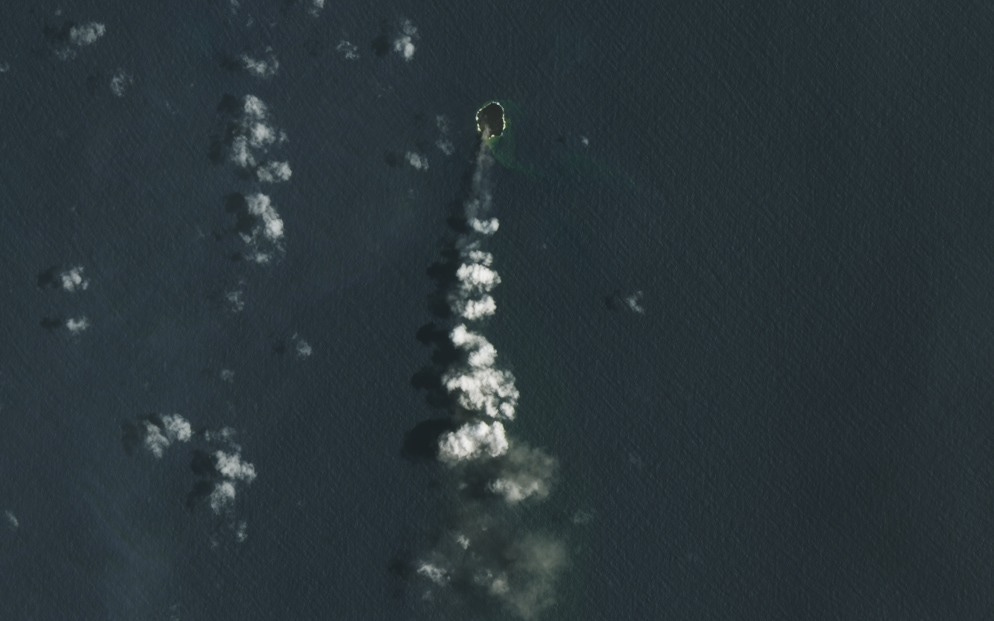
A Growth Spurt for Home Reef [link]
"A small island at Tonga’s Home Reef got a little roomier in recent weeks.
The underwater volcano emerged above sea level during a 2022 eruption, adding new land to the nation of islands in the South Pacific Ocean. It continued to grow during eruptions in September 2023, January 2024, and June 2024, expanding to 12.2 hectares (30.1 acres). During the most recent period of activity, from December 2024 to January 2025, the island grew another 3.7 hectares."
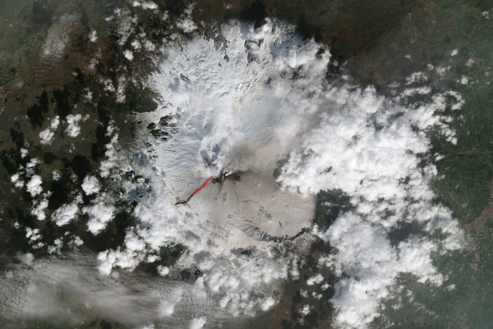
River of Fire on Mount Etna [link]
"On February 8, 2025, Italy’s National Institute of Geophysics and Volcanology (INGV) reported that Mount Etna had begun exhibiting “signs of unrest above its background level.” That’s unsurprising for the frequently unruly Sicilian peak, one of the most active stratovolcanoes in the world. But the fiery explosions, disruptive ash clouds, and long lava flows that ensued stood out as being unusually spectacular to many Etna watchers."
Interesting reads
Welcome to the Satellite Hunger Games [link]
With nearly 20 years in the geospatial industry, Kevin brings a wealth of skills and experience to his new publication!
His first post, Satellite Hunger Games, is a must-read for anyone navigating the complexities of satellite imagery procurement.
Glacier melt intensifying freshwater loss and accelerating sea-level rise [link]
"Ice melting from glaciers around the world is depleting regional freshwater resources and driving global sea levels to rise at ever-faster rates.
According to new findings, through an international effort involving 35 research teams, glaciers have been losing an average of 273 billion tonnes of ice per year since the year 2000 – but hidden within this average there has been an alarming increase over the last 10 years."
Publication in Nature: Community estimate of global glacier mass changes from 2000 to 2023 [link]
Related:
Glacial melting increases freshwater loss and accelerates sea level rise [link]
New ATMOS 2024 conference report and recommendations [link]
"The conference report from ATMOS2024 has just been released, a comprehensive document detailing highlights of the talks and posters presented at the conference held in Bologna, Italy, in July 2024. Fundamentally, the outcomes of this conference were used to develop a series of community-derived recommendations to ESA which are included in the report.
This year’s discussions brought together over 300 experts from 25 countries to showcase the latest developments and results from ongoing research and application development activities using data from past and current ESA and third-party atmospheric instruments."
Open Roles
EO Scientist Role at ARGANS [link]
Deadline : 24 February 2025Scientific Officer (forests fires, Earth observation and geospatial analysis) at the Joint Reseach Centre [link]
Open roles at GHGSAT [link]
Operations Delivery, Team Lead - DATA.AIR
Geospatial Data Engineer
Sales Development Rep (Houston, TX)
Back-End Developer
Data Platform Developer
Environmental Data Scientist at Kanop [link]
Land Surface Modeller at ECMWF [link]
Senior Python Engineer at UP42 [link]
Earth Science Writer at NASA [link]