

Call for Testimonials: How are you using Copernicus data? [link]
"The Copernicus Atmosphere Monitoring Service (CAMS) and the Copernicus Climate Change Service (C3S) provide vital Earth observation data for scientific research, policy-making, and industry applications. They are collecting testimonials from professionals utilizing CAMS and C3S—whether in academia, environmental monitoring, or decision-making.
Your insights will help shape the future of these services and may be featured in reports, presentations, and communication materials. Share your experience and contribute to the global impact of Copernicus."
Level-2 News
Spire and OroraTech win Canadian Space Agency contract for wildfire detection satellites [link]
"The Canadian Space Agency (CSA) awarded a contract Feb. 7 to Spire Global, partnered with OroraTech, to develop a constellation of cubesats to monitor wildfires.
CSA and other Canadian government officials announced that Spire’s Canadian subsidiary, Spire Global Canada, won a contract worth $72 million Canadian ($50.4 million) to develop 10 satellites for the WildFireSat constellation for launch in 2029.
A CSA spokesperson told SpaceNews that the constellation will have seven active satellites and two on-orbit spares, along with an additional spare satellite on the ground. The spokesperson added that the precursor satellite is not considered part of the WildFireSat constellation and that the WildFireSat spacecraft will be built in Canada.
The satellites will be 12-kilogram 8U cubesats, each equipped with two infrared cameras and one optical/near-infrared multiband camera."
BlackSky to launch next-gen imaging satellite as it seeks market edge [link]
"BlackSky is set to launch its most sophisticated Earth observation satellite as early as next week as the company looks to strengthen its position in the increasingly competitive remote sensing market.
The satellite, part of BlackSky’s new Gen-3 series, will provide high-resolution 35-centimeter imagery, an improvement that aligns with demands from U.S. and international government customers. The company announced on Feb. 10 that the first Gen-3 satellite is scheduled to launch as early as Feb. 18 aboard a Rocket Lab Electron rocket from the company’s New Zealand launch site."
Urban Sky raises $30 million for stratospheric balloons [link]
"Urban Sky, a company that has developed portable stratospheric balloons to perform imaging and other applications typically done by satellites, has raised $30 million to expand its work."
Satellogic and Telespazio Brasil announce Multi-Year Contract for Low-Latency Satellite Imagery for the Brazilian Air Force [link]
"Satellogic and Telespazio Brasil, a subsidiary of Telespazio S.p.A have entered into a multi-year agreement with the Brazilian Air Force (Força Aérea Brasileira, FAB) to provide low-latency satellite imagery for defense and security operations within the Brazilian territory. The contract offers an initial one-year term and one-year extension option."
ICEYE and SATIM enter partnership on joint development for new, AI-powered SAR imagery analysis products [link]
"ICEYE and SATIM have today announced the signing of partnership agreement for joint product development. The companies will combine ICEYE’s satellite imagery with SATIM’s AI-powered imagery analytics solutions into new products enabling prompt, high-confidence detection and classification of vessels, aircraft, and land vehicles. After an initial pilot phase, the partners plan to release a series of generally-available products in 2025."
NOAA partners with Brightband to make observational data AI-ready [link]
"NOAA’s Physical Sciences Laboratory and Global Systems Laboratory and the artificial intelligence startup Brightband have entered into a two-year Cooperative Research And Development Agreement (CRADA) that will optimize a vast NOAA-managed archive of observational weather data for training artificial intelligence (AI)-based weather forecasting applications.
Under the CRADA, “Making NOAA Observation Data Artificial Intelligence-Ready,” NOAA will collaborate with Brightband to transform the NOAA NASA Joint Archive of observational data from satellites, weather balloons and surface stations into an open-source data a repository that will support a suite of geospatial foundation AI models. The joint archive is a collaboration between NOAA and NASA that has developed a homogenized repository of Earth System observations from 1970 to present."
Developer's Orbit
Pangeo Showcase: High-performance Python STAC tooling, backed by Rust [link]
"In this talk, Pete Gadomski walks through the existing Python STAC ecosystem and showcases new developments, including stac-geoparquet innovations, STAC API queries using DuckDB, and cloud-storage-agnostic access for STAC and its assets. Much of this new tooling is written in Rust and exposed with Python bindings. Pete talks a bit about how that works, the benefits, and the drawbacks."
Top Geospatial Python Packages 2024 [link]
Follow this post by Matt Forrest, as he identifies the most downloaded geospatial Python packages, highlighting the "industry's shift toward scalable and interoperable geospatial analytics".
Data
Observation and ERA5-Land derived 9 km global daily fire fuel characteristics since 2003 [link]
"The dataset provides daily estimates of fuel load and fuel moisture content, distinguishing between live and dead vegetation. It combines observations from multiple remote sensing platforms with state-of-the-art land surface models. The dataset will be expanded to incorporate additional observations from upcoming missions and will be periodically updated to cover more recent periods." [link]
McNorton, J. R. and Di Giuseppe, F.: A global fuel characteristic model and dataset for wildfire prediction, Biogeosciences, 21, 279–300, https://doi.org/10.5194/bg-21-279-2024, 2024.
Earth Science Data Roundup: February 2025 [link]
"A summary of datasets, products, and resources released by NASA’s Distributed Active Archive Centers (DAACs) in January 2025."
The datasets/products I have highlighted:
CMS-Flux Global Fire Carbon Emissions Product Now Available
Soft Release of VIIRS Nighttime Lights Products
GEDI Level 4C Footprint Level Waveform Structural Complexity Index, Version 2 Released
AVIRIS-3 Level 2A Orthocorrected Surface Reflectance, Facility Instrument Collection Dataset Now Available
Aquascope and Caeloscope will provide new data products for marine applications and air quality monitoring [link]
"Two new projects, Aquascope and Caeloscope, will provide satellite-based information products to enhance the data services within Terrascope and transform research from Belgian federal scientific institutes into publicly accessible insights.
Aquascope, led by the Royal Belgian Institute of Natural Sciences, will provide marine information products for the Belgian North Sea.
Caeloscope, led by the Royal Belgian Institute for Space Aeronomy, will focus on extending the data products for Air Quality monitoring.
All datasets will be made available via the Terrascope services, including the TerrascopeViewer, STAC catalog, Jupyter Notebooks, VirtualMachines, and openEO."
So what does the Earth look like in 10cm? More data added to the awesome gee-community-catalog [link]
Wyvern Open data datasets (from last week)
Long Wave Infrared Imagery & 10cm Very High-Resolution RGB from Urban Sky Open Data
Q4 Solar assets release from TransitionZero
Global Long-term Microwave Vegetation Optical Depth Dataset Archive (VODCA v2)
"In numbers: 200GB+ of new data added in the last week, 12,000+ new images, and thousands of new features across collections."

Snapshots

Earth from Space: Snow-capped Swiss Alps [link]
"Extending some 1200 km, the Alps occupy an area of about 200 000 sq km and are home to some 20 million people. The image shows the Bernese Alps, which form the central part of the Swiss Alps."
Climate
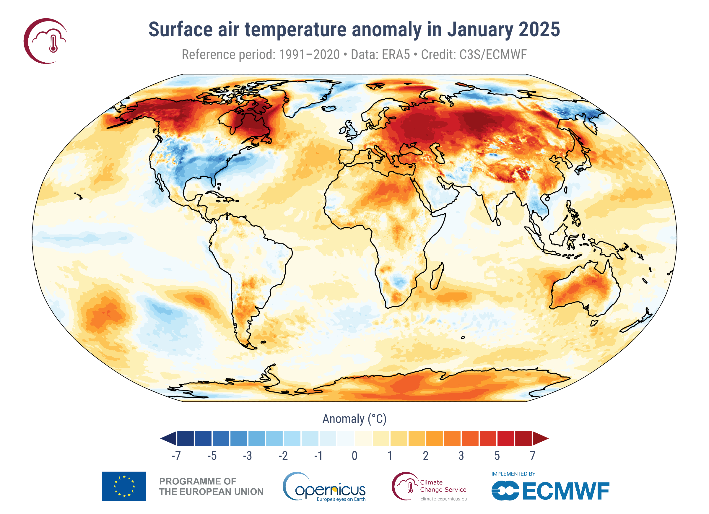
January 2025 was the warmest on record globally, despite an emerging La Niña [link]
"January 2025 was the warmest January globally, with an average ERA5 surface air temperature of 13.23°C, 0.79°C above the 1991-2020 average for January.
January 2025 was 1.75°C above the pre-industrial level and was the 18th month in the last nineteen months for which the global-average surface air temperature was more than 1.5°C above the pre-industrial level.
The last 12-monthsperiod (February 2024 – January 2025) was 0.73°C above the 1991-2020 average, and 1.61°C above the estimated 1850-1900 average used to define the pre-industrial level."
Related:
We’re About to Reach the Paris Agreement Limit, If We Haven’t Already [link]
"Earth has probably already entered the 20-year period in which global temperatures will be, on average, 1.5°C (2.7°F) higher than preindustrial conditions."
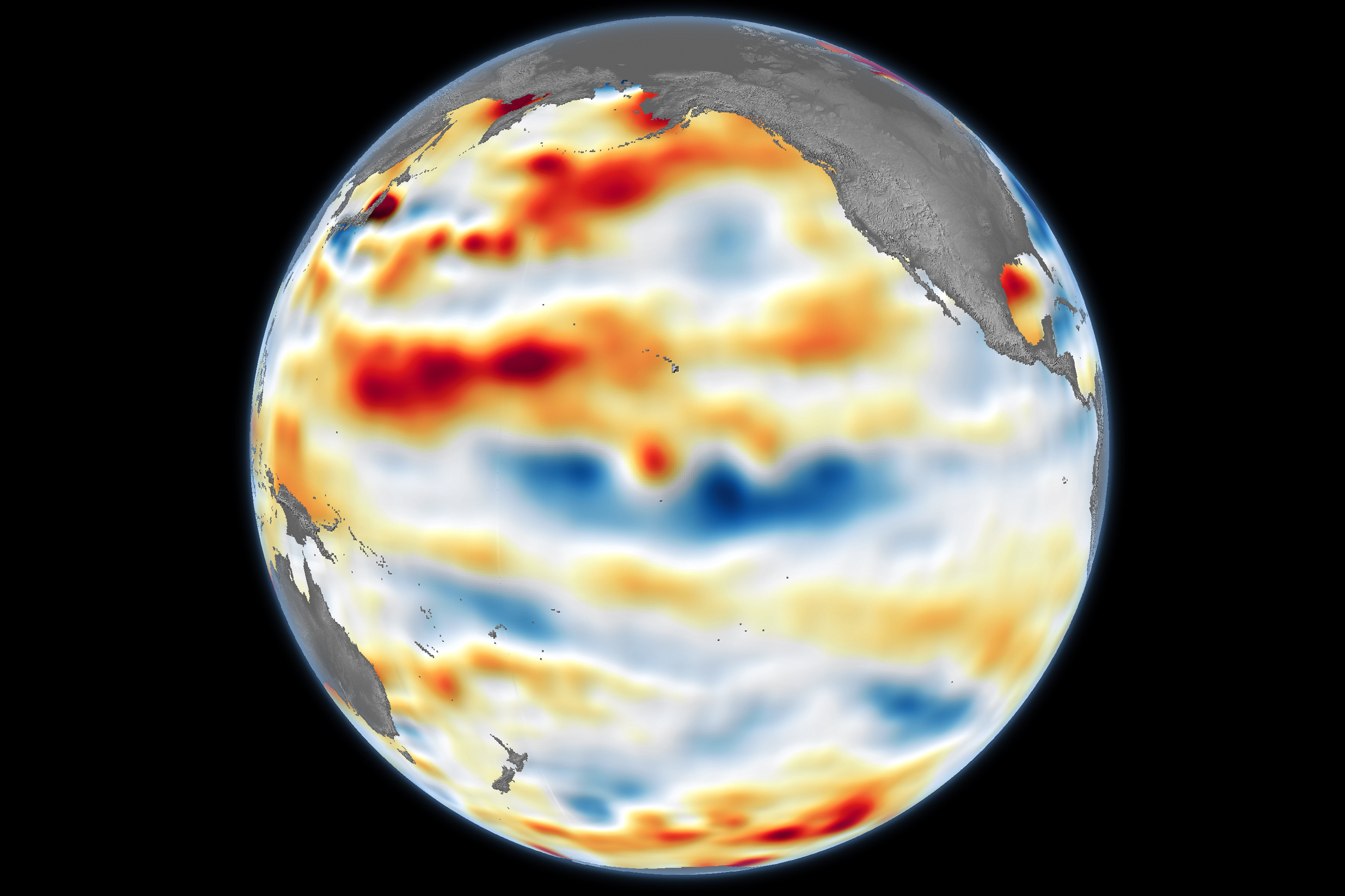
La Niña Is Here [link]
"After seven months of waiting, La Niña—the cooler sister of El Niño—finally showed up in the eastern Pacific Ocean in early December 2024. La Niña may not stick around long, though. According to NOAA, the Pacific may return to neutral conditions in spring 2025.
The signature of La Niña is also visible in the central and eastern Pacific Ocean as areas of lower-than-average water levels. That’s because cooler water contracts, lowering sea levels. (Conversely, warmer water expands, raising them.) The map above depicts sea surface height anomalies across the central and eastern Pacific Ocean as observed on January 13, 2025. Shades of blue indicate sea levels that were lower than average, while shades of red indicate areas where the ocean stood higher than normal. Normal sea level conditions appear in white.
Data for the map were acquired by the Sentinel-6 Michael Freilich satellite and processed by scientists at NASA’s Jet Propulsion Laboratory (JPL)."
Interesting reads
Satellites might be the unlikely heroes in the climate crisis [link]
"Earth is changing faster than many people realize, and more voices are calling for urgent responses to climate-related threats.
Many health professionals see daily reminders of how shifting temperatures and extreme weather can harm public well-being. One approach gaining traction is the use of satellite and space-based data to map environmental risks."
Duo of satellites detects large methane emissions from volcano in Ethiopia [link]
"SRON—as part of the European CAMS service—and GHGSat have detected a substantial methane emission from Mount Fentale, an active volcano in Ethiopia. The emission, estimated at 58 metric tonnes per hour, was observed on January 31 through a “tip and cue” approach between Europe’s Copernicus program’s Sentinel-5P TROPOMI satellite instrument and GHGSAT’s satellite constellation, coordinated by SRON and GHGSAT."
LinkedIn Highlights
Sebastian Robertson's post on Australia’s EO resilience and securing Australia's long-term EO capabilities [link]
In the context of mitigating Australia's EO Data access risks, Sebastian Robertson, President of Earth Observation Australia (EOA), highlights key findings from a report compiled by EOA, Symbios and The University of Queensland, last year:
171 Australian government programs rely on Earth observation data.
93% of these programs have a medium to high dependency on satellite EO data.
100% of this data comes from foreign sources, with no binding agreements to guarantee continued supply.
In 2020 Earth observation directly contributes $283 million to the Australian economy and underpins over $2.5 billion in economic activity annually (data for a 2021 Deloitte report)
Keith Cowing post about the absence of NASA and NOAA from the upcoming meeting of the Committee on Earth Observations Satellites (CEOS) [link]
Upcoming Events
Amini Geospatial AI Series: Where and how to source EO data? [link]
"This is an introduction to finding and downloading earth observation data for machine learning. It will predominantly focus on downloading Sentinel-2 data for regions in Africa. This session will touch on the fundamentals of Remote Sensing."

Dataviz Webinar Series [link]
"Discover how to turn ocean data into compelling visual stories with the Dataviz Webinar Series, hosted by the Copernicus Marine Service and Mercator Ocean international."
Day 1 : February 20, 2025
Day 2: March 6, 2025
Day 3: March 20, 2025
Open Roles
Senior Geospatial Data Scientist - ICEYE [link]
"ICEYE is seeking an experienced Senior Geospatial Data Scientist to join their Natural Catastrophe Solutions product team that is focused on deriving actionable insights about disasters like floods, wildfire and hurricane damage."
Geospatial Data Engineer - GHGSat [link]
"GHGSat is looking for a Geospatial Data Engineer based in London, UK, who will play a key role in building and optimising their geospatial data and AI/ML pipelines to support GHGSat's mission of driving climate impact. This role involves integrating geospatial data from various sources, designing robust data systems, and contributing to analysis and insights generation."
ESA Graduate Trainee Onboarding New Space EO Solutions in Copernicus Contributing Missions [link]
"ESA is looking for a Graduate Trainee to join them and work on New Space EO Solutions in Copernicus Contributing Missions!
This is a unique opportunity to gain hands-on experience, collaborate with experts, and contribute to the future of Earth observation at ESA."
Technical Program Manager on Tanager- Planet [link]
"Planet is looking for a Technical Program Manager to orchestrate cross-functional efforts and serve as the accountable owner for the overall hyperspectral program on the Product and Software side of Planet."