

Level-2 News
Wyvern announced the launch of their Open Data Program [link]
"Wyvern's Open Data Program provides free hyperspectral satellite images to the earth observation community to help support the creation of transformative applications across industry, government, and academia. Data is available under the creative commons public license (CC BY 4.0), allowing unrestricted access with proper attribution.
Alongside the launch of the Open Data Program, Wyvern's Knowledge Centre has been updated to include tutorials related to working with Wyvern data in ENVI, QGIS, ArcGIS, and others."
SKY Perfect JSAT is the customer behind Planet’s $230 million LEO order [link]
"Japan’s SKY Perfect JSAT unveiled itself as the customer behind the low Earth orbit (LEO) imagery constellation that San Francisco-based Planet announced last week, committing $230 million to expand beyond its geostationary business.
The Japanese operator said Feb. 5 it will own Pelican high-resolution optical imagery satellites provided by Planet under a U.S.-based entity called JSAT Beyond Innovation, a move likely aimed at enhancing access to the country’s expansive defense market.
A Planet spokesperson said the agreement covers 10 satellites."
SpaceX launches third pair of Maxar’s WorldView Legion imaging satellites [link]
"A SpaceX Falcon 9 rocket launched two Earth observation satellites for Maxar Intelligence Feb. 4, completing the deployment of the company’s next-generation WorldView Legion constellation.
The mission marks a significant milestone for Maxar, a Colorado-based provider of geospatial intelligence, as it finalizes the deployment of its fleet of high-resolution imaging spacecraft."
Aramco, GHGSat to develop satellites for methane emissions reduction [link]
"Aramco and GHGSat have joined forces to help address a notable source of greenhouse gas emissions. GHGSat was contracted by Aramco Americas (a wholly-owned subsidiary of Aramco) to monitor methane based on the success of an earlier pilot program."
Fugro acquires EOMAP, adding unique satellite analytics to its water market solutions [link]
"Fugro has acquired EOMAP, a provider of mapping and monitoring solutions for marine and freshwater environments through satellite Earth Observation (EO)."
Developer's Orbit
NASA Earth data training webinar - Examining Hurricane Milton’s Milestones with NASA's GES DISC Datasets
"This webinar utilizes several datasets available at NASA's Goddard Earth Sciences Data and Information Services Center (GES DISC), including data from the cutting-edge Time-Resolved Observations of Precipitation structure and storm Intensity with a Constellation of Smallsats (TROPICS) Mission along with Modern-Era Retrospective analysis for Research and Applications, Version 2 (MERRA-2), and Land Data Assimilation System (LDAS) datasets to investigate the factors that made Milton a remarkable, record-setting hurricane. A Jupyter Notebook demonstration shows you how to access and visualize the datasets used in the webinar with the earthaccess Python library."
Presentation slide deck [link]
GRIded Binary and weather data [link]
"With the power of dearimgui and ECCODES, and thanks to AI tools like Ollama and Codestral, Jean-Baptiste Filippi recently rewrote gribview.cpp. It can now open a 22GB GRIB file with 4000+ fields at 3600x1800 resolution in under 5 seconds, allowing you to zoom, explore, and extract images effortlessly."
gribview is available on the Spatiotemporal Data Compression Workflow called Metflix [link]

Snapshots
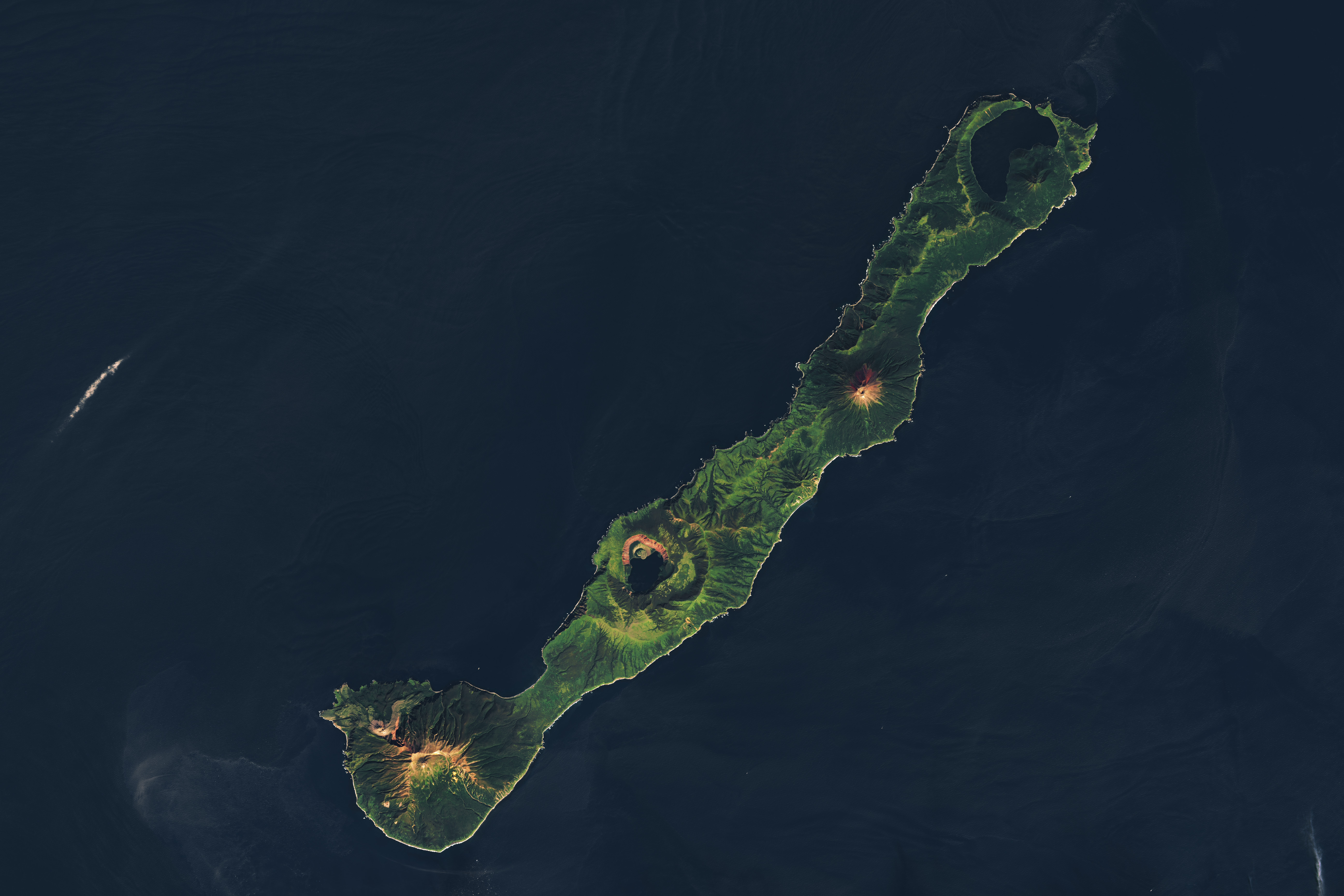
Nested Calderas of Zavaritskogo [link]
"In the remote northwest corner of the Pacific Ocean, a dotted line of islands stretches between northern Japan and Russia’s Kamchatka Peninsula. The Kuril Archipelago is sparsely populated by humans but riddled with volcanoes.
The Zavaritskogo volcano (also called Zavaritskii) is a striking feature on Simushir Island, in the middle of the archipelago. It is made up of nested, steep-walled calderas surrounding a central lake."
Interesting reads
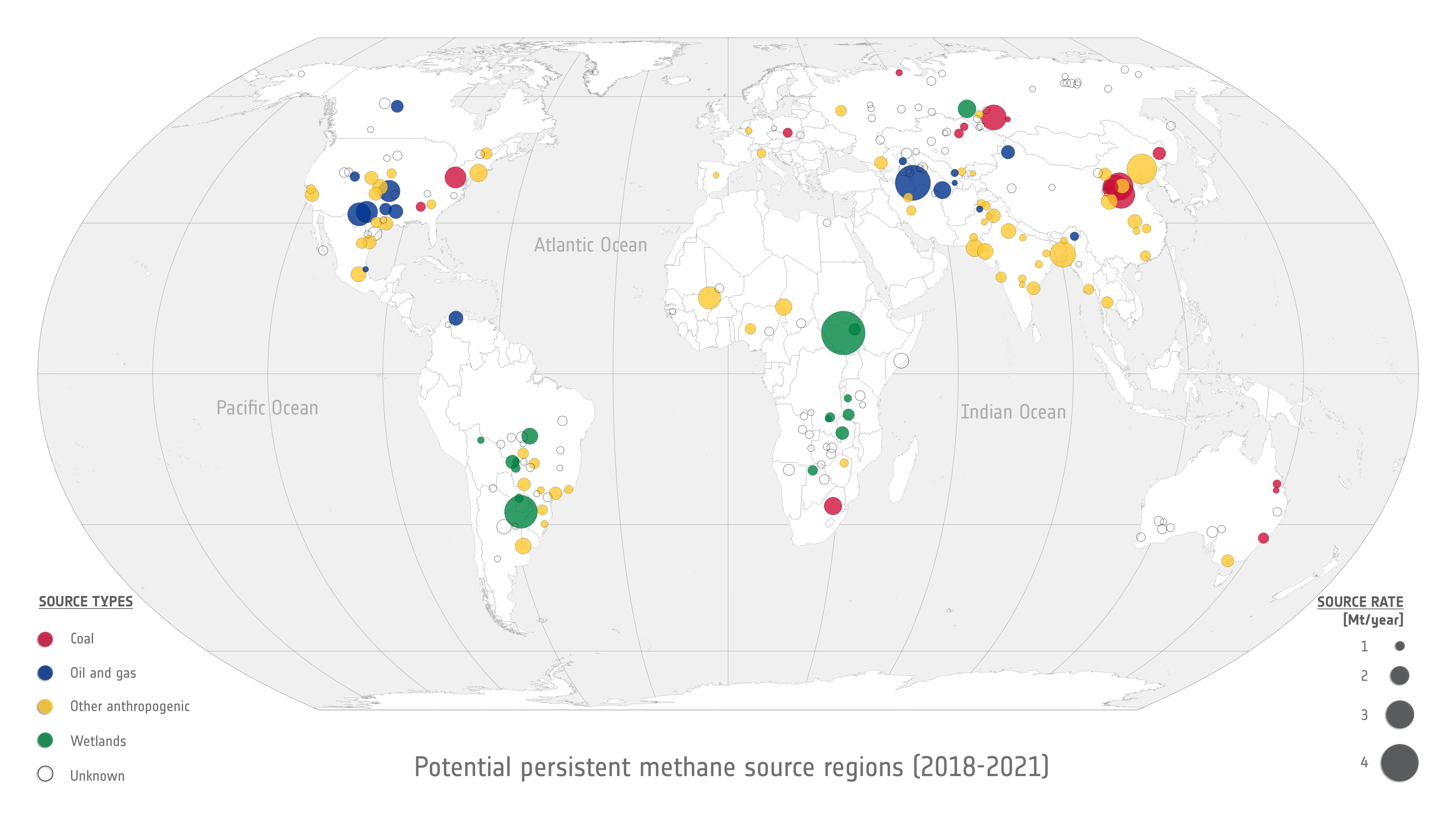
Top 10 persistent methane sources [link]
"A list of the top 10 global regions where natural or anthropogenic sources emit methane on a continuous, ‘persistent’ basis was recently published in a scientific journal.
The study analysed data and measured emissions from hundreds of potential sources of methane based on satellite data.
Data from the Copernicus Sentinel-5P mission was used to study and estimate methane emissions at 217 potential locations.
The paper, published in Atmosphere, Chemistry and Physics, focused on sources that emit methane gradually over time, in contrast to ‘super-emitters’ – typically oil and gas operations, coal mines or poorly managed landfills – which release disproportionately large amounts of methane but not on a continuous basis."
Related:
Another 300+ plumes from Tanager-1 were just published to Carbon Mapper's data portal [link]
NASA’s Cloud-based Confluence Software Helps Hydrologists Study Rivers on a Global Scale [link]
"Rivers and streams wrap around Earth in complex networks millions of miles long, driving trade, nurturing ecosystems, and stocking critical reserves of freshwater.
But the hydrologists who dedicate their professional lives to studying this immense web of waterways do so with a relatively limited set of tools. Around the world, a patchwork of just 3,000 or so river gauge stations supply regular, reliable data, making it difficult for hydrologists to detect global trends.
‘Confluence,’ an analytic collaborative framework that leverages data from NASA’s Surface Water and Ocean Topography (SWOT) mission and the Harmonized Landsat Sentinel-2 archive (HLS) to estimate river discharge and suspended sediment levels in every river on Earth wider than 50 meters. NASA’s Physical Oceanography Distributed Active Archive Center (PO.DAAC) hosts the software, making it open-source and free for users around the world."
LinkedIn Highlights
Ryan Abernathey's takeaways from attending the Geospatial Risk Summit in NYC [link]
Samapriya Roy's post on data integration for large scale analysis [link]
Follow Samapriya Roy's post, prompted by the recent launch of Wyvern's Open Data Program, as he reflects on the evolution of hyperspectral satellite data and looks forward to the strategies that will enable data integration at scale.
Upcoming Events

NASA Data Training Webinar Opportunity: NASA ICESat-2 Land and Vegetation Height Product [link]
"Join the second webinar in a multi-part ICESat-2 Data Training webinar series on Wednesday, February 12, 2025, at 2 p.m. EST (-05:00 UTC) to learn how to work with NASA's ICESat-2 land and vegetation height data. A live demonstration will showcase the SlideRule Earth web service which provides on-demand science data processing of ICESat-2 and other geospatial data."
The first webinar in this four-part webinar series:
Laser Altimetry Applications for a Changing World: Explore ICESat-2 Data [link]
FireSight Demo: A Tool for Visual Understanding of Machine Learning Predictions for Wildfires [link]
"In this talk, Lazaro Alonso will present FireSight, an interactive demo designed for visualizing Earth Observation array datasets."
Date: 07 February 2025, 16:40 - 17:00 CET
ELLIS Summer School: AI for Earth and Climate Sciences [link]
"The 2025 ELLIS Summer School on AI for Earth & Climate Sciences is the premier event for ELLIS PhD students, MSc students, and postdocs at the intersection of machine learning and geoscience to meet in person. During the week filled with keynotes, hands-on classes and project work the school will focus on cutting-edge research and discuss the latest advancements in the field. This interdisciplinary program will shape the future for the community of AI, Earth and Climate scientists by fostering collaboration among the next generation of interdisciplinary researchers.
Early Application Deadline: March 31, 2025"
Competitions
AI Weather Quest [link]
"The AI Weather Quest, organised by the European Centre for Medium-Range Weather Forecasts (ECMWF), is an ambitious international competition designed to harness artificial intelligence (AI) and machine learning (ML) in advancing weather forecasting. It challenges participants to produce and submit sub-seasonal weather forecasts – covering the critical weeks between medium-range and seasonal predictions – using AI/ML models."
From Spectral Reflectance
Reflections from the Thermal Remote Sensing Workshop 2024

This past December, I attended the Thermal Remote Sensing (TRS) Workshop in Leicester, UK. With no prior background in TRS, I was a bit skeptical about how much I’d gain from the workshop, but it turned out to be incredibly insightful.
Open Roles
The 2025 European Space Agency - ESA Graduate Trainee programme is now open! [link]
"One position to fill in Climate Science at ECSAT, home of European Space Agency - ESA in the UK, in the Actionable Climate Information Section."
PostDoc Opportunity – MethaneSAT Science [link]
"EDF is hiring a PostDoc to analyze MethaneSAT data and advance methane emissions research. If you have a PhD in atmospheric science, remote sensing, or a related field, this is your chance to make a real climate impact!
Apply by: Feb 28, 2025"
EUMETSAT is hiring! [link]
"Explore exciting opportunities to shape the future of satellite meteorology, including:
Space Segment Security Engineer
Translator (English/French)
Digital Solution Coordinator"
Learning
The 1st WorldCereal Massive Open Online Course on Reference Data for Crop Type Mapping is live [link]
"The WorldCereal team will organize three distinct online courses. The goal of these courses is to provide a broad conceptual background to the topic of (global) cropland mapping and monitoring for any interested user. The 1st WorldCereal Massive Open Online Course (MOOC) on reference data for crop type mapping is now available.
The first course offers expert-led presentations, hands-on demonstrations, and practical exercises on different aspects related to reference data for crop mapping."
WorldCereal MOOCs Page [link]
Remote Sensing Image Segmentation with AI: Hands-On Workshop with the Segment Anything Model
Slides [link]
Access the Notebook [link]
Explore on GitHub [link]
I hope the NASA data will still be there.