


Earth Observation Groundbreaking Science Discoveries [link]
"The “ESSC ESA EO Groundbreaking Science Discoveries” has been released: it explores 12 examples of how the European Space Agency - ESA and Earth observation have enabled groundbreaking scientific discoveries and their benefits to society.
A few notable examples of how ESA EO satellites have helped scientists, just in the last 10 years:
🛰️ Gain insight on methane super emitters thanks to the Sentinel-5P, capturing global methane levels with a fine spatial resolution of 5.5 by 7 kilometres.
🛰️ Significantly improve weather forecast thanks to AEOLUS innovative doppler lidar that enhanced the accuracy of weather forecasts by providing critical wind data, particularly in regions where observations were sparse or unavailable, such as over the tropics, oceans, and polar areas.
🛰️ Assessed the grim reality of our planet’s ice sheets thanks to missions like Cryosat and SMOS.
🛰️ Closely monitored and contributed to a better understanding of Earth’s carbon cycle thanks to Sentinel-1, Sentinel-2, Sentinel-3 and SMOS data and soon also with measurements from the BIOMASS mission, set to launch in 2025."
Level-2 News
Planet Launches “Single Order Tasking” Portal Powered by SkyFi [link]
"SkyFi today announced the launch of Single Order Tasking in collaboration with Planet. This new pay-as-you-go satellite tasking option “Powered by SkyFi” makes it faster and easier than ever to acquire high-resolution imagery."
Pixxel Launches World’s Highest-Res Hyperspectral Satellite Constellation [link]
"Pixxel, a Bengaluru-based space technology company building the world’s highest-resolution hyperspectral satellite constellation, has successfully launched the first three satellites of its Firefly constellation.
The satellites were integrated via Exolaunch and launched aboard the Transporter-12 rideshare mission with SpaceX from Vandenberg Space Force Base, California, USA."
U.S. intelligence agency selects 13 companies for satellite data contract [link]
"The U.S. National Geospatial-Intelligence Agency (NGA) announced Jan. 15 it selected 13 companies for a $200 million contract to provide commercial satellite data and analytics, marking a shift in how the intelligence agency acquires critical information for national security.
The 13 selected vendors are: Airbus U.S. Space & Defense; BAE Systems; Booz Allen Hamilton; BlackSky; BlueHalo; CACI; Deloitte; Electromagnetic Systems; Maxar Intelligence; NV5 Geospatial; Planet Labs; Royce Geospatial; and Ursa Space Systems."
Second SAR satellite advances Space42’s hybrid connectivity and imagery vision [link]
"Emirati operator Space42 said Jan. 15 it has established communications with its recently launched Foresight-2 satellite, the second synthetic aperture radar (SAR) payload for the hybrid imaging and connectivity provider.
Provided by Finnish SAR operator Iceye, Foresight-2 was one of 131 payloads SpaceX sent to sun-synchronous orbit Jan. 14 on a Falcon 9 rocket."
Xplore launches hyperspectral satellite for multispectral constellation [link]
"Xplore is now in control of XCUBE-1, the first satellite in the Bellevue, Washington, startup’s planned 12-satellite constellation.
XCUBE-1, a six-unit cubesat launched Dec. 21 on a SpaceX Falcon 9 rideshare from Vandenberg Space Force Base in California, will supply data for space domain awareness, precision agriculture, forestry management, astronomy and other applications.
XCUBE-1 will provide Earth-observation data in an array of spectral bands at a resolution of 4.2 meters per pixel. Additional satellites in Xplore’s constellation will be equipped with multiple sensors."
China launches Earth observation satellite for Pakistan [link]
"China launched the first satellite of a remote sensing constellation for Pakistan, with two domestic spacecraft also along for the ride.
PRSC-EO1 is the first of a series of three optical remote sensing satellites for Pakistan, which will join the country’s existing remote sensing satellites, PRSS-1 and PakTES-1A, in orbit.
These satellites will provide data for the fields of land mapping, agriculture classification and assessment, urban and rural planning, environmental monitoring, natural disaster monitoring and management, surveying, natural resources protection and others uses, according to Pakistan’s Space and Upper Atmosphere Research Commission (SUPARCO)."
Planet hires former Space Force chief to its board amid defense push [link]
"Planet has appointed retired U.S. Space Force General John “Jay” Raymond to its board of directors, as the company seeks to expand its footprint in the defense and intelligence markets.
Raymond, who served as the first Chief of Space Operations for the U.S. Space Force and is currently a senior managing director at private equity firm Cerberus, brings extensive military space expertise to Planet as it competes with established players like Maxar Intelligence and BlackSky for government contracts."
BlackSky Wins 1-Year Extension for EOCL Contract with the NRO [link]
"BlackSky Technology won a one-year extension with the National Reconnaissance Office (NRO) for the Electro-Optical Commercial Layer (EOCL) contract for its satellite imagery."
Developer's Orbit

A building damage assessment toolkit [link]
"In disaster response, every minute counts. This toolkit, developed by Microsoft and used by the Microsoft AI for Good Lab, helps first responders and humanitarian teams quickly identify damaged buildings and infrastructure using remote sensing data, enabling them to prioritize and allocate resources more effectively."
Sharing some tools for working with GeoParquet [link]
Check out this post by Chris Holmes, about his recently released collection of tools for GeoParquet, using PyArrow and DuckDB.
geoparquet-tools on GitHub [link]
Geo-Sam : Segment anything in QGIS [link]
Follow the installation guide and the imagery samples provided by MAXAR, along with Hans van der Kwast's tutorial on using Geo-Sam with QGIS.
STAC Browser v3.3.0 has been released [link]
"The most significant improvements are:
Support for STAC v1.1.0
Support for recent versions of STAC extensions
New languages
Better authentication system, supporting OpenID Connect, HTTP Basic and API keys
Improved social sharing"

Snapshots
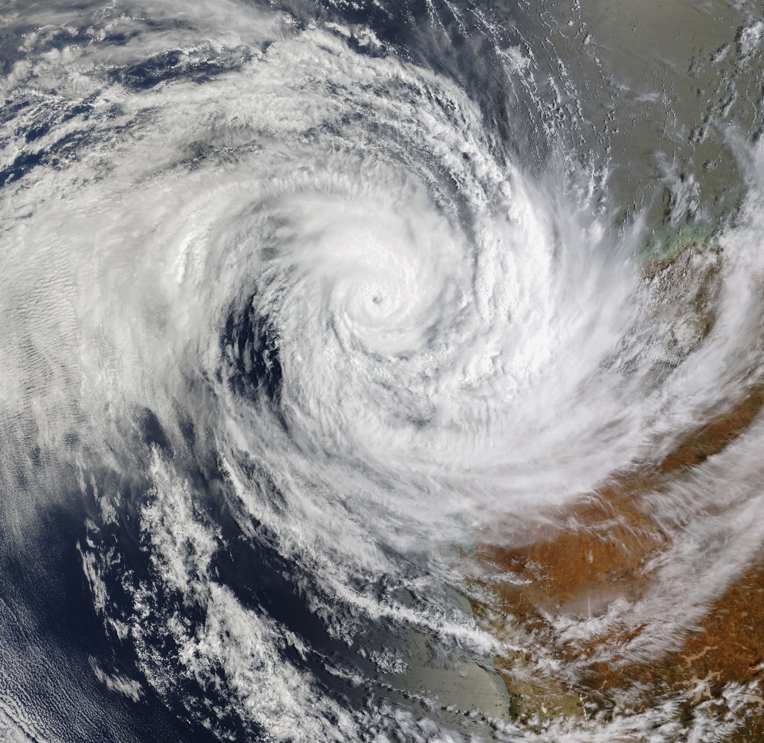
Tropical Cyclone Sean Lashes Western Australia [link]
"On January 17, 2025, a tropical low formed over the Indian Ocean off Western Australia. By January 19, the storm had strengthened into Tropical Cyclone Sean—the second tropical cyclone of Australia’s 2024–2025 season."
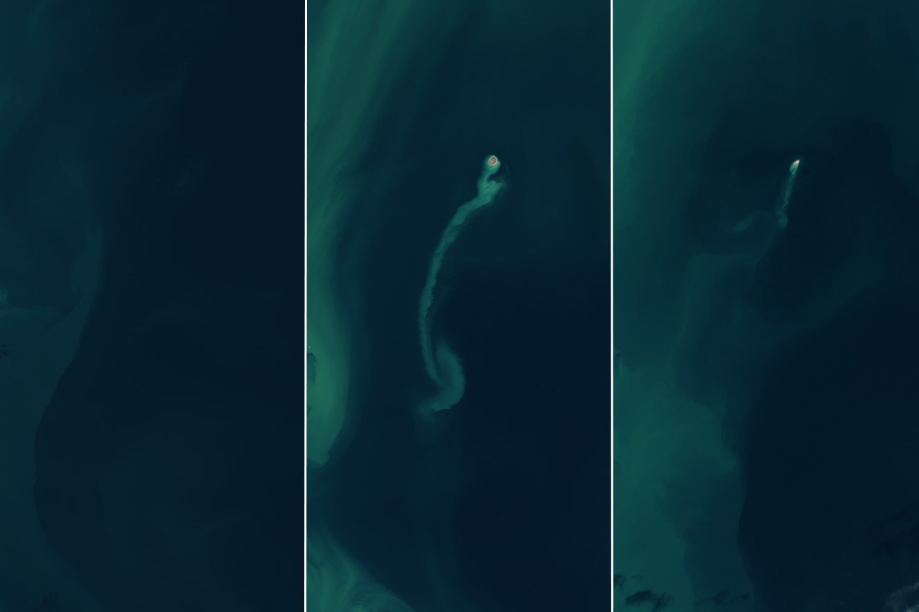
Satellites Spot a “Ghost” Island [link]
"An island emerged from the Caspian Sea after a mud volcano erupted in early 2023. By the end of the following year, it had nearly eroded away, retreating from view like an apparition. Powerful eruptions of the Kumani Bank mud volcano have produced similar transient islands several times since its first recorded eruption in 1861. Also known as Chigil-Deniz, the feature is located about 25 kilometers (15 miles) off the eastern coast of Azerbaijan.
The OLI (Operational Land Imager) and OLI-2 on the Landsat 8 and 9 satellites captured these images showing the island emerge and shrink. In November 2022 (left), the crest of the volcano remained below the sea surface. By February 14, 2023 (middle), an island had appeared, and a sediment plume drifted away from it. By the end of 2024 (right), a greatly diminished portion of Kumani Bank was visible above the water."
Climate
Pioneering research exposes huge loss of glaciers in one of the fastest-warming places on Earth [link]
"A new study has revealed the alarming extent glaciers have shrunk over the past 40 years in a global warming hotspot for the first time – and the biggest retreat has occurred in recent years.
The research, led by the University of Bristol and published in Nature Communications, shows the vast majority (91%) of glaciers across Svalbard in the Arctic have been significantly shrinking. Findings revealed an area loss of more than 800 km2 at the glacier margins in this Norwegian group of islands since 1985.
The study also found that more than half of the glaciers (62%) undergo seasonal cycles in glacier calving – when large chunks of ice break away due to higher ocean and air temperatures."
Interesting reads
Telling The True Tale of Chronic Oil Pollution in the UK’s North Sea [link]
"Ocean advocacy organization Oceana UK launched an investigation into chronic oil pollution from offshore infrastructure in the UK’s North Sea using Skytruth's map-based tool, Cerulean, creating compelling visual assets for a public education campaign and advocacy efforts targeting offshore oil activity."
New data analysis technology delivers unprecedented Arctic insights [link]
"An innovative satellite data analysis method that delivers fresh insight into small water bodies in remote landscapes has revealed hundreds of small lakes in the Arctic."

How the new NASA and India Earth Satellite NISAR will see Earth [link]
"When NASA and the Indian Space Research Organization's (ISRO) new Earth satellite NISAR (NASA-ISRO Synthetic Aperture Radar) launches in coming months, it will capture images of Earth's surface so detailed they will show how much small plots of land and ice are moving, down to fractions of an inch.
Imaging nearly all of Earth's solid surfaces twice every 12 days, it will see the flex of Earth's crust before and after natural disasters such as earthquakes; it will monitor the motion of glaciers and ice sheets; and it will track ecosystem changes, including forest growth and deforestation."
Catalysing Business Engagement in Early Warning Systems [link]
"Businesses can both contribute to, and benefit from, early warning services, according to a new joint white paper from the World Meteorological Organization and World Economic Forum, in collaboration with the Australian National University.
The white paper, Catalysing Business Engagement in Early Warning Systems, was presented at the World Economic Forum’s prestigious annual meeting in Davos. Environmental risks – led by extreme weather - have become the greatest source of long-term concern and are projected to intensify over the next decade, according to the WEF Global Risks Report, which underscores concern about the impact on business operations, supply and distribution chains, and the workforce.
Early Warnings for All – ensuring that every person on Earth is protected by early warnings - is a global challenge that will require the combined efforts of the public and private sectors and will not be possible without the vast and innovative capabilities of businesses,” WMO Secretary-General Celeste Saulo told a panel discussion entitled What’s Going on with the Weather."
Nord Stream pipelines: analysis of methane emissions following damage [link]
"At the end of September 2022, almost half a million tonnes of methane were released into the atmosphere due to damage to the Nord Stream pipelines. This is the largest amount of the greenhouse gas methane released in a single event. This conclusion comes from analysis by the International Methane Emissions Observatory (IMEO) from the United Nations Environment Programme (UNEP). Nearly 70 scientists from 30 research organisations collaborated on the analysis."
Upcoming Events

Earth Observation data preprocessing and super resolution modelling for active fire detection [link]
"Learn about innovative approaches to EO data and discover how super resolution technology contributes to improving fire detection and prevention. This is your opportunity to engage with cutting-edge developments in GeoAI and exchange ideas with experts."
29 January 2025 at 12:30 CET
Call for Papers
International Workshop on AI Foundation Models for Earth Observation [link]
"This workshop on Foundation Model for Earth Observation and Earth Sciences aims to address these challenges by bringing together experts from AI, geospatial science, climate, weather and Earth observation communities. The goal is to foster interdisciplinary collaboration, share the latest research and technological advancements, and discuss practical solutions for effectively integrating FMs into the Earth Observation and Earth Sciences ecosystems."
Abstract Submission Deadline: 31 January
Resources
Map and location data and tools for wildfires [link]
"In response to the terrible wildfires in the LA area and in an attempt to consolidate, DevelopmentSeed created a list (still being updated) of geospatial resources designed to assist emergency responders, researchers, decision-makers, and analysts in accessing relevant and actionable information."