

Level-2 News
SpaceX launches 131 satellites on Transporter 12 rideshare mission [link]
"A Falcon 9 rocket carrying 131 different payloads lifted off on the company's Transporter 12 mission from Vandenberg Space Force Base on January 14 at 2:09 p.m. EST."
Over 50 of them are EO payloads [link]:
"Planet launched Pelican-2 Satellite & 36 SuperDoves. [link]
OroraTech has Forest-3, an 8U CubeSat with a thermal imaging payload for wildfire detection.
Satellogic had UzmaSAT-1 (NewSat-45), a high-resolution earth observation satellite built for Malaysia’s Uzma.
Norway had the 35 kg satellite NORSAT-4. Like the earlier NORSAT spacecraft, this has an AIS ship tracking payload and, additionally, a low-light imager to detect ships greater than 30m long in dark Arctic waters.
Spire has six LEMUR spacecraft on the flight. Three of the 3U LEMUR 2 satellites will have radio occultation and AIS maritime tracking payloads.
TRL Space from the Czech Republic launched TROLL, a 6UXL spacecraft with a hyperspectral imager from Simera Sense.
French firm Absolut Sensing has GESat GEN1, a 16U spacecraft to monitor methane emissions.
Bulgaria’s Endurosat has Balkan-1, a 16U CubeSat with a 1.5 m-resolution multispectral imager and onboard AI image processing, the first of a constellation supported by the European Space Agency (ESA) and the European Union.
Pakistan has PAUSAT-1, a 16U collaboration between Pakistan Air University and Türkiye’s ITU SSDTL with a hyperspectral imaging payload.
Pixxel has the first three satellites in its Fireflies constellation of hyperspectral imaging satellites. These 52 kg spacecraft capture more than 150 spectral bands at 5 m resolution with a 40 km swath width.
Argotec has IRIDE-MS2-HEO-1 for its HEO (Hawk for Earth Observation) constellation, which is part of Italy’s IRIDE Earth observation constellation. The HEO satellites have optical imaging payloads with onboard image processing.
Spain’s Satlantis has GARAI A, the first of a pair of 115 kg satellites with two camera systems for visible and infrared (VNIR/SWIR) imaging.
SkyBee-1 is the first microsatellite for Constellr’s HiVE constellation. These satellites will take high-precision land surface temperature readings to help monitor water stress for agriculture. Germany’s OroraTech has Forest-3, an 8U CubeSat with a thermal imaging payload for wildfire detection.
ICEYE has four of its 90 kg synthetic aperture radar (SAR) satellites. These include another satellite for their customer Space42 of the United Arab Emirates."
Germany, Italy, and the UK Slash ESA Contributions by €430M [link]
"The European Space Agency’s 2025 budget has dropped below its 2024 level after Germany, Italy, and the United Kingdom collectively cut their contributions by €430 million.
During his annual press briefing on 9 January, ESA Director General Josef Aschbacher revealed that the ESA budget for 2025 would be €7.68 billion, down from €7.79 billion in 2024.
The largest share of the European Space Agency’s 2025 budget, €2.58 billion, was allocated to Earth Observation, accounting for 33.6% of the total, an increase of 3.1% from 2024."
Maxar Wins €13.6M Contract with Dutch MoD [link]
"Maxar Intelligence has won a €13.6M ($14.4M) contract to be the eyes in the skies for the Netherlands Ministry of Defence.
Maxar will help the Ministry of Defence use the geospatial data for missions including mapping, intelligence collection, and supporting missions on the ground."
Dutch Ministry of Defence selects Airbus as multi-year supplier of satellite data via Airbus’ OneAtlas platform [link]
"Airbus Defence and Space and The Netherlands Ministry of Defence have entered on 7 January 2025 into a four-year agreement to provide optical, radar, analytics, elevation and advanced products through the OneAtlas platform. This collaboration will support intelligence operations, mission planning and decision-making processes of the ministry."
World's 1st wooden satellite deploys from ISS to demonstrate cleaner spacecraft tech [link]
"An experimental satellite made of wood has been deployed from the International Space Station (ISS) to test how the renewable, sustainable material withstands the harsh orbital environment.
The satellite, designed and built by Kyoto University and Japanese wood processing company Sumitomo Forestry, is called LignoSat, a reference to the organic polymer lignin, which is prevalent in wood cells.
The 1U cubesat — a cube measuring 4 inches (10 centimeters) on a side — will remain in space for about six months before it gets pulled back into Earth's atmosphere by drag. The mission might open new avenues for spacecraft design at a time when the potential environmental impact of satellite reentries faces increasing scrutiny."
Dragonfly Aerospace to Provide Imagers for LatConnect 60 SWIRSAT Satellites [link]
"Dragonfly Aerospace will supply Australian Earth observation company LatConnect 60 with three Chameleon SWIR (shortwave Infrared) imagers for their SWIRSAT satellites, Dragonfly announced Jan. 7."
BlackSky Reports Wins With Space Force TacSRT Pilot Program [link]
"BlackSky has won multiple contracts for its analytics services through a new pilot program from the U.S. Space Force’s Global Data Marketplace (GDM), the company announced."
Tomorrow.io NextGen offers high-resolution rain forecasts [link]
"Weather intelligence startup Tomorrow.io unveiled NextGen, a global-precipitation forecasting platform, Jan. 14 at the American Meteorological Society annual meeting here.
NextGen ingests data from Boston-based Tomorrow.io satellites to provide global precipitation forecasts with a resolution of 2.5 kilometers, updated every five minutes.
Tomorrow.io operates a constellation of six satellites: two Ka-band radar satellites launched in 2023 and four satellites with microwave sounders launched in 2024. Additional satellites are scheduled to launch in 2025.
The Defense Department has awarded Tomorrow.io contracts with a value of more than $20 million. And the National Oceanic and Atmospheric Administration is assessing Tomorrow.io weather data under a $2.3 million contract announced in October."
Moody’s to acquire geospatial AI intelligence provider CAPE Analytics [link]
"Moody’s Corporation has reportedly agreed to acquire CAPE Analytics, a provider of geospatial AI intelligence for residential and commercial properties across the U.S., Canada, and Australia.
According to Moody’s, it will combine its Intelligent Risk Platform and catastrophe risk modelling with CAPE’s geospatial AI analytics, building a property database that provides address-specific risk insights."
Developer's Orbit
Zarr-Python 3 is here! [link]
"After more than a year of development, Zarr-Python 3 is here! This major release brings full support for the Zarr v3 specification, including the new chunk-sharding extension, major performance enhancements, and a thoroughly modernized codebase.
Zarr-Python 3 is available on PyPI and Conda-Forge. It is compatible with Python 3.11 and above."
Data
Earth Science Data Roundup: January 2025 [link]
"A summary of datasets, products, and resources released by NASA’s Distributed Active Archive Centers (DAACs) in December 2024."

Snapshots
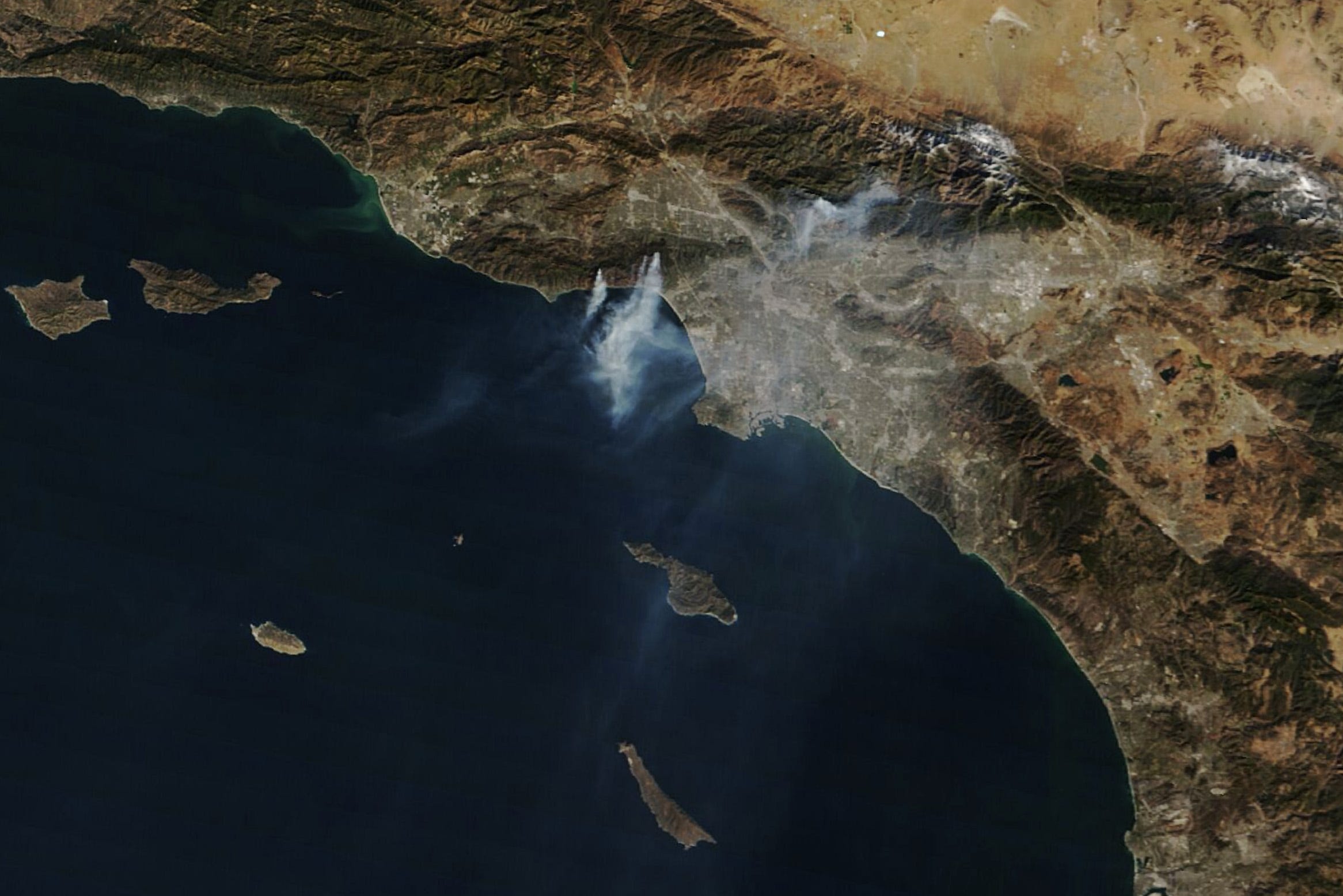
Smoke Streams from Palisades and Eaton Fires [link]
"Destructive fires, fueled by a dry landscape and powerful Santa Ana winds, burned in the Los Angeles area in January 2025. Smoke from the Palisades and Eaton fires, which both broke out on January 7, was visible in satellite imagery for several days after they ignited. They were the largest of several fires that burned in the area as strong winds tore through the region."
Climate

The 2024 Annual Climate Summary; Global Climate Highlights 2024 [link]
"2024 saw unprecedented global temperatures, following on from the remarkable warmth of 2023. It also became the first year with an average temperature clearly exceeding 1.5°C above the pre-industrial level – a threshold set by the Paris Agreement to significantly reduce the risks and impacts of climate change. Multiple global records were broken, for greenhouse gas levels, and for both air temperature and sea surface temperature, contributing to extreme events, including floods, heatwaves and wildfires. These data highlight the accelerating impacts of human-caused climate change."
Related:
2024 is the Warmest Year on Record [link]

My new dark red climate stripe for 2024 shows it’s the hottest year yet [link]
"No words, no numbers – just a striking visual which highlights the ongoing warming of our planet. A total of 175 stripes representing each year since 1850, coloured by the global temperature in that year. Blues for colder years, reds for hotter years. It doesn’t need much more explanation for anyone to understand.
These “warming stripes”, adopted around the world as a symbol of climate awareness, action and ambition, have just been updated to include a new dark red stripe for 2024."
Interesting reads
Earth Observation in 2024 and Outlook for 2025 [link]
Read through this insightful piece by Aravind on what happened in EO in 2024 and what to look forward to in 2025.
Identification of major persistent methane source regions [link]
"The anthropogenic emissions of methane (CH4), after those of carbon dioxide (CO2), are the second most important man-made source of greenhouse gases contributing to global warming. Over a 20-year timescale, each kilogram of methane emitted has a global warming potential more than 80 times more potent than carbon dioxide. Reducing methane emissions would help to reduce global warming.
A recently published scientific study uses TROPOMI data from the Sentinel-5 Precursor (S5P) satellite to automatically determine methane concentrations and identify regions of persistent methane concentrations. This study identified 217 major potential methane source regions, estimated their emissions and created a global map of their distribution, shown in the figure above."
LinkedIn Highlights
This reflection from Bruno Sanchez after attending CES2025 [link]
With the LA fires in our view, Bruno Sanchez, the Executive Director of Clay, highlights the contrast between AI-sprinkled consumer tech innovation and the urgent need for systemic AI solutions to tackle real-world challenges.
"The contrast was jarring: this explosion of "AI sugar" versus the struggle to deploy AI for society's real bottom line: We know how to use AI to predict fires like those ravaging LA. We've seen demos of AI prediction of fire risks in the very same areas buring today... showcasing the risks of building with wood, unmanaged vegetation, no rain, and high winds uphill. We do have the tech, the data, the modeling capabilities, ... but we're failing to translate that into action."
~ Bruno Sanchez ~
Call for Papers
3rd ML4RS Workshop [link]
"This workshop promotes trans-disciplinary research through diverse view-points to tackle the pressing questions of our times, such as climate change, social inequalities, biodiversity, and food security. Developing modern machine learning approaches tailored towards remote sensing data is key to investigating these problems efficiently. This third Machine Learning for Remote Sensing (ML4RS) workshop promotes this exchange by allowing researchers to present their research on environmentally and societally important applications and/or innovative methods that can have an impact in such application domains."
Submission Deadline - February 3rd, 2025