

Level-2 News
Iceye raises additional $65 million [link]
"Iceye has added $65 million to a funding round it announced in April, bringing the total amount the synthetic aperture radar (SAR) satellite imaging company has raised to more than $500 million."
Balearic Islands to Launch First Sat in 2025 [link]
"One of Europe’s tourism hot spots has commissioned Open Cosmos to build a satellite to track whether climate change could put the islands’ economy under water, the company announced today.
The government of the Balearic Islands—an archipelago that includes Mallorca, Ibiza, Menorca, and Formentera—will fund the sat’s construction, which will be carried out in collaboration with Wireless DNA, a telecommunications firm; the University of the Balearic Islands; Garden Hotels; and support from the Hotel Business Federation of Mallorca. The satellite will monitor changes in the Western Mediterranean’s climate to boost resilience in the island chain’s tourism sector."
Developer's Orbit
ODC-STAC Talk by Caitlin Adam of Geoscience Australia [link]
"A short webinar by Caitlin Adams, on the odc-stac Python package for loading Earth observation data into Xarrays."
Zarr-Python 3.0 is dropping next week [link]
"If your project depends on Zarr-Python, make sure to check out the migration guide to get ready for the update."

Snapshots
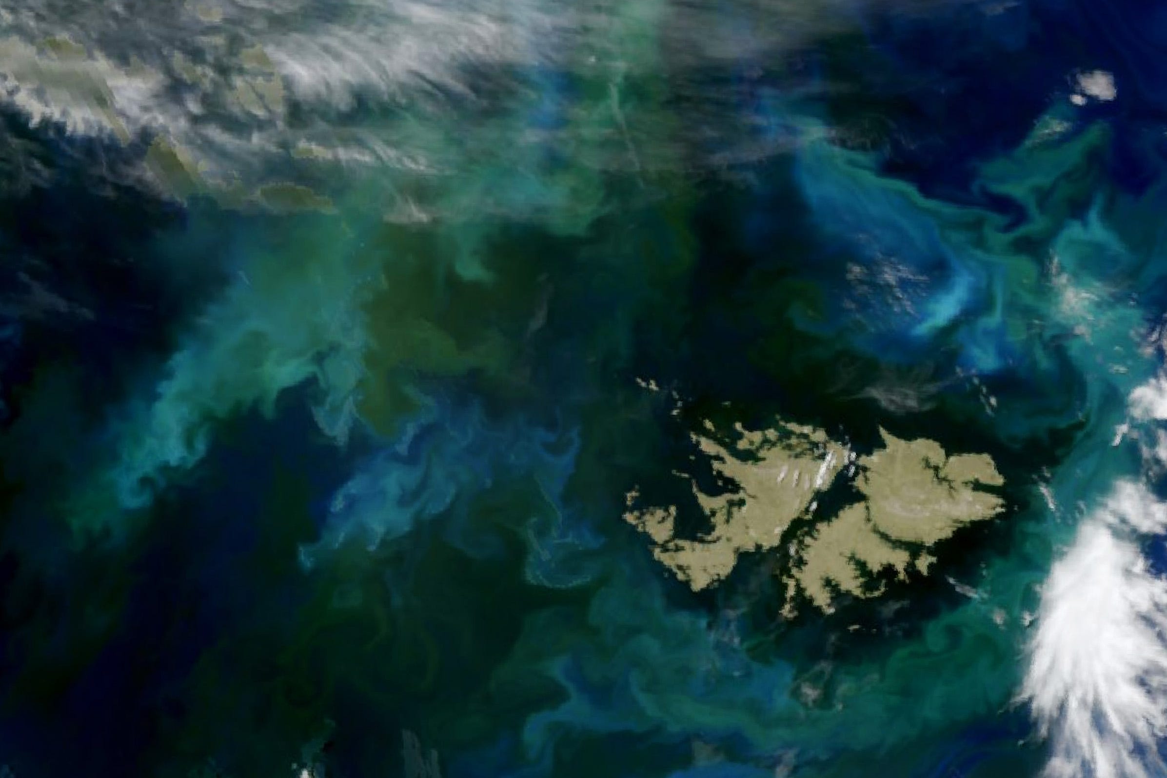
Phytoplankton Flourish in Patagonian Waters [link]
"Bloom season, already underway for several months, continued to dazzle in the productive South Atlantic waters off Argentina. Earlier, in austral spring 2024, satellites captured a clear image of a sizeable phytoplankton bloom along the Patagonian Shelf. Communities of the tiny aquatic organisms persisted into the long days of the Southern Hemisphere summer, painting surface waters in shades of green and blue into late December."
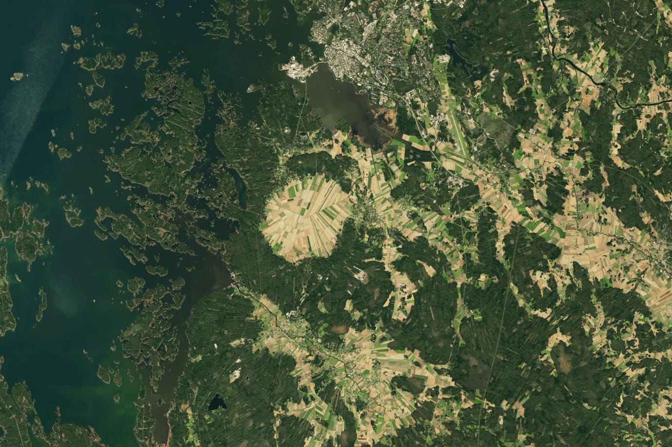
The Many Facets of Söderfjärden [link]
"More than half a billion years ago, a meteorite struck Earth near the Antarctic Circle, leaving a divot several kilometers in diameter. In the hundreds of millions of years that followed, the movement of Earth’s tectonic plates brought that cratered piece of crust far into the Northern Hemisphere.
Today, the Söderfjärden impact crater occupies a 22 square-kilometer piece of coastal real estate in western Finland near the Gulf of Bothnia, the Baltic Sea’s northern arm."
Söderfjärden interests planetary scientists because of its geometric shape. Some have described the Finnish crater as “the best sample of a hexagonal impact structure on Earth.”"
Interesting reads
How US-Indian NISAR Satellite Will Offer Unique Window on Earth [link]
"The upcoming U.S.-India NISAR (NASA-ISRO Synthetic Aperture Radar) mission will observe Earth like no mission before, offering insights about our planet’s ever-changing surface.
The NISAR mission is a first-of-a-kind dual-band radar satellite that will measure land deformation from earthquakes, landslides, and volcanoes, producing data for science and disaster response. It will track how much glaciers and ice sheets are advancing or retreating and it will monitor growth and loss of forests and wetlands for insights on the global carbon cycle."
Follow this Q&A with the lead U.S. scientist of the mission, Paul Rosen.
LinkedIn Highlights
John Fisher's comment on the market disruption potential of small weather sats [link]
Follow this post by John Fisher, CEO of Brandywine Photonics, commenting on a recent article.