

🎄 Happy Holidays from Spectral Reflectance! 🎁

2024 in Review
ESA's Top Earth observation stories of 2024 [link]
"This year has been a whirlwind of fascinating Earth observation stories, from dramatic volcanic eruptions to Saharan dust plumes to epic meteorite craters. This post features some of the most memorable highlights from 2024."
2024 in Review: Highlighting the Best of Landsat [link]
"In 2024, Landsat proved its worth once again with new land cover products and science contributions—and was validated by a report estimating the mission's economic value at $25.6 billion USD! That progress includes preparing for our upcoming mission, Landsat Next, through agreements with international partners. This year, we also reminisced about Landsat 7 as its mission came to a close."
2024 in Review: EROS celebrates annual NLCD, Landsat 7's 25-year-mission [link]
"As 2024 comes to a close, this post reflects on some key achievements and experiences this year at the U.S. Geological Survey Earth Resources Observation and Science (EROS) Center."
A year in ML for weather forecasting [link]
"2024 is almost over, and it hasn’t been a quiet or slow one. Machine learning (ML) for weather and climate has continued to evolve at breathtaking pace, even staying up to date with news and developments around the world is looking like a full-time job."
Level-2 News
The commissioning phase of the Copernicus Sentinel-2C is now officially over [link]
Simonetta Cheli, the Director of ESA Earth Observation Programmes and Head of ESRIN, announced in a post on LinkedIn that the commissioning phase of the Copernicus Sentinel-2C is now officially over.
"The satellite underwent rigorous in-orbit verification and commissioning, which has included some particularly spectacular moments, such as the images of the Moon for its instrument calibration or the image of Sentinel-2C taken by Sentinel-2B .
The satellite has met its requirements and it’s now ready to start operations, supporting a large range of applications such as agriculture, emergency management or methane emissions monitoring."
Maxar signs $35 million satellite intelligence deals in Asia-Pacific region [link]
"Maxar Intelligence has secured contracts worth $35 million to provide satellite imagery and analytics services to two undisclosed Asia-Pacific governments.
The deals announced Dec. 19 will give these governments access to Maxar’s newly deployed WorldView Legion satellites, which provide high-resolution Earth observation imagery, as well as synthetic aperture radar (SAR) data from partner company Umbra."
Synspective Goes Public on Tokyo Stock Exchange [link]
"Synspective, the Japanese builder and operator of SAR satellites, became a public company on December 18, with shares opening at $4.70 and closing at $4.11, for a market cap of ~$357.3M. The company raised more than $60M from the offering."
China nears record launch year with Ceres-1 and SAR satellite missions [link]
"The Ceres-1 mission followed a launch sending four synthetic aperture radar (SAR) satellites into orbit Dec. 16.
Aboard were four Piesat-2 (numbered 09-12) SAR satellites developed by commercial satellite manufacturer GalaxySpace. The satellites are equipped with SAR payloads, intelligent processing systems and mission planning capabilities. GalaxySpace is one of a number of companies in China developing SAR satellites."
ESA signs launch contract for climate mission FORUM with Avio [link]
"ESA has officially signed a launch service contract with Avio for the upcoming FORUM mission. Scheduled for launch in late 2027, FORUM—short for Far-infrared Outgoing Radiation Understanding and Monitoring—will lift off on a Vega-C rocket from Europe’s Spaceport in French Guiana.
FORUM is set to deliver the first-ever global spectrally resolved measurements from orbit of Earth’s outgoing longwave radiation over an extremely large range in the far-infrared spectrum.
The satellite will carry two advanced optical instruments: the FORUM Sounding Instrument (FSI) and the FORUM Embedded Imager (FEI).
FORUM will operate in tandem with the MetOp-Second Generation satellite in a sun-synchronous orbit at 830 km altitude."
Developer's Orbit
Introducing Placemaker Tools : Empowering Communities to Shape the Future of Places [link]
"Building on the debut of their new Places Engine and the FSQ OS Places launch, Foursquare introduced the beta release of Placemaker Tools."

Snapshots
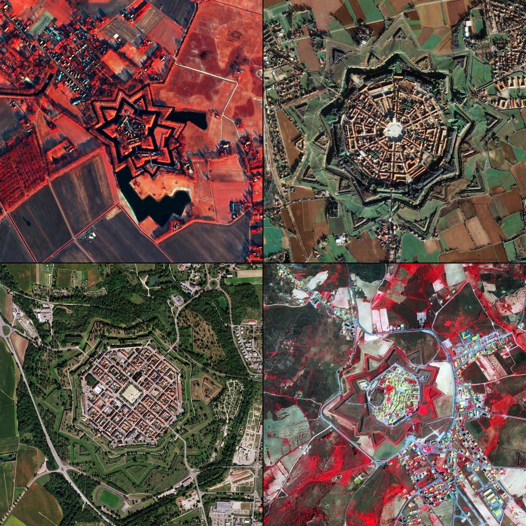
Earth from Space: Star cities [link]
"With the festive season approaching, even Earth-observing satellites are getting into the spirit, capturing a stunning compilation of European cities that resemble stars."
1 HOUR Relaxing Satellite Imagery
"Landsat satellites capture images of the Earth’s surface. While the sensors aboard Landsat capture a wide range of scientifically useful wavelengths, this collection reveals natural color imagery in the red, green and blue parts of the visible spectrum, as if viewed by the naked eye from 438 miles above the surface. Scenes like these help scientists and communities around the world study our changing planet."
Climate
La Niña may develop, but it is likely to be weak and short-lived [link]
"La Niña conditions may develop in the next three months but are expected to be relatively weak and short-lived, according to the latest Update from the World Meteorological Organization.
La Niña refers to the large-scale cooling of the ocean surface temperatures in the central and eastern equatorial Pacific Ocean, coupled with changes in the tropical atmospheric circulation, such as winds, pressure and rainfall. Generally, La Niña produces the opposite large-scale climate impacts to El Niño, especially in tropical regions."
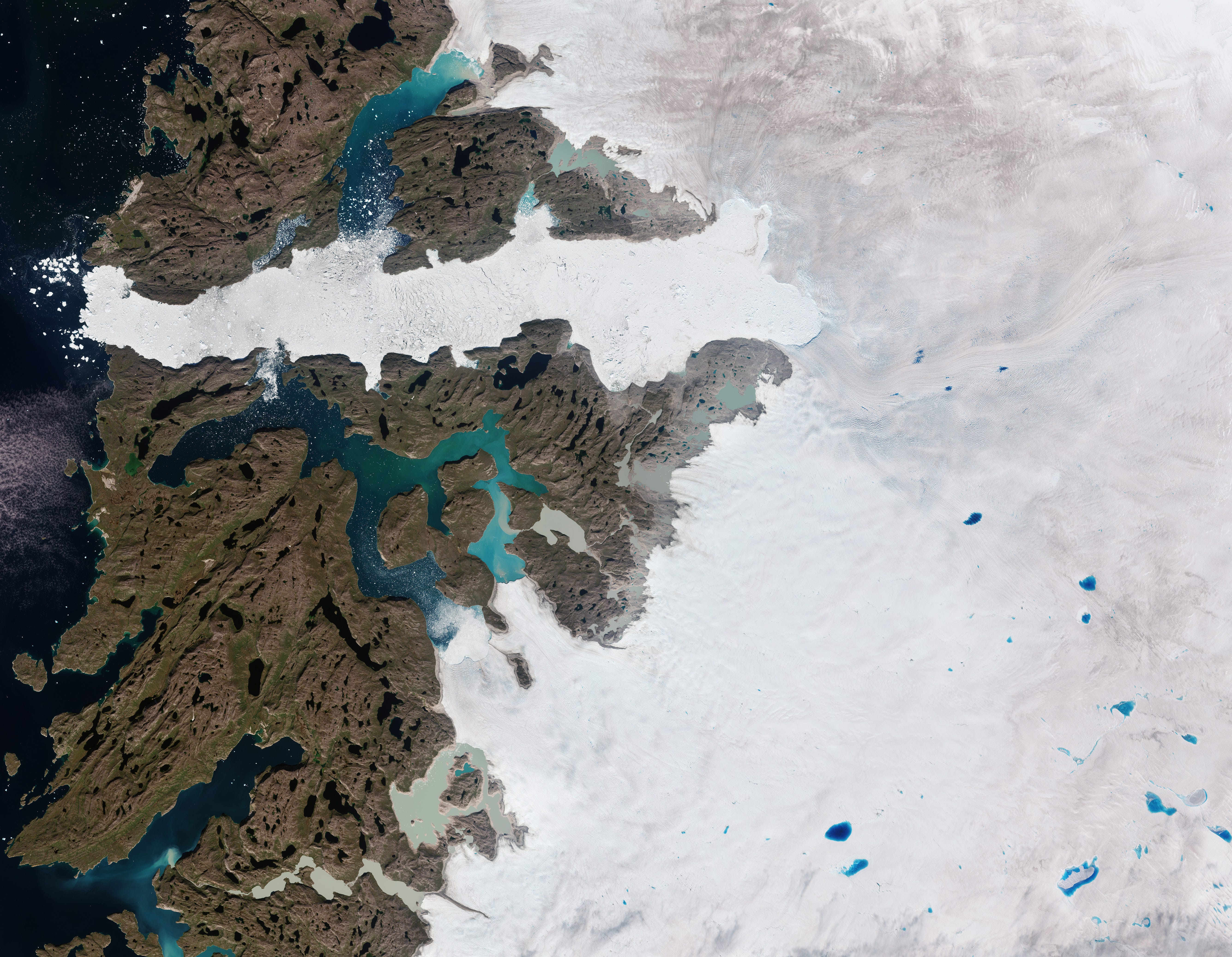
ESA and NASA deliver first joint picture of Greenland Ice Sheet melting [link]
"Global warming is driving the rapid melting of the Greenland Ice Sheet, contributing to global sea level rise and disrupting weather patterns worldwide. Because of this, precise measurements of its changing shape are of critical importance for adapting to climate change.
Now, scientists have delivered the first measurements of the Greenland Ice Sheet’s changing shape using data from ESA's CryoSat and NASA's ICESat-2 ice missions."
Interesting reads
RUDEO: paving the way for a sustainable future with Earth Observation and Blockchain [link]
"The RUDEO Hackathon, funded by ESA Φ-lab and implemented by GMV, took place between 24-25 October 2024, in a hybrid format. Participants were encouraged to propose solutions, leveraging Blockchain and Earth Observation (EO) technologies, in domains such as Climate Action and Resilience, Sustainable Supply Chains and Resource Management, and Risk Assessment and Insurance.
The winner of the hackathon was CO2 Angels. Within the ‘Sustainable Supply Chains and Resource Management’ theme, the team proposed an app to monitor and manage agricultural emissions using satellite data and blockchain, aimed at improving sustainability in supply chains."
A Day in the Life of GeoXO [link]
"Using data from current satellites, A Day in the Life of GeoXO imagines what this new generation of geostationary Earth observing satellites will see, and how their instruments will work together to provide near real-time information to forecasters, decision-makers, and first responders. GeoXO will contribute to the protection of life and property within the United the States. All in a day's work."
An introduction to thermal infrared [link]
Follow this post by UP42 introducing thermal imaging. From precision agriculture to disaster response, thermal satellite imagery provides vital insights about the Earth's surface.
Upcoming Projects
Detecting and Monitoring Land Use Transformation in Córdoba, Argentina Using Satellite Imagery [link]
"Join Omdena Argentina's latest project to detect and monitor land-use changes in Córdoba, Argentina, using satellite imagery."
Happy New Year, Akis!