

"On December 14, the average annual temperatures from 1706 to 2024 from the KNMI - The Dutch national research and information centre for meteorology, climate and seismology - were projected on the Utrecht Dom on the occasion of 'colour the city'. On display again on the Dom on Tuesday evening, December 24."
Level-2 News
Maxar partners with Satellogic to enhance monitoring for defense agencies [link]
"The agreement grants Maxar exclusive rights to task, collect and distribute imagery from Satellogic’s high-revisit satellite constellation to support the U.S. government and international partners"
Foursquare partners with OpenAI and ChatGPT search [link]
"Through Foursquare's Places API — featuring over 100M+ points of interest from 200+ countries — ChatGPT search is serving users real-time locations relevant to their queries."
Earth Observation Just Got a Major Upgrade With Sentinel-1C [link]
"Sentinel-1C, launched via the Vega-C rocket, enhances Europe’s capacity for high-resolution Earth monitoring and introduces maritime traffic detection technologies. This launch is a pivotal moment for European space independence and technological advancement in environmental monitoring."
Geomagnetic storms cause “mass migrations” of satellites [link]
"A pair of major geomagnetic storms this year led to unprecedented “mass migrations” of thousands of satellites in low Earth orbit that create new concerns about space traffic coordination."
L3Harris ramps up satellite production in response to military demand [link]
"Defense contractor L3Harris is scaling up satellite manufacturing and is moving to automate the production of infrared sensor payloads"
Cecil is partnering with Google to make nature data accessible [link]
"Cecil is partnering with Google to provide Google Earth Engine (GEE) datasets on Cecil's nature data platform. This collaboration will enable Cecil customers to access datasets from the GEE Data Catalog."
Developer's Orbit
Faster Xarray Quantile Computations with Dask [link]
"There have been a number of engineering improvements to Dask Array like consistent chunksizes in Xarray rolling-constructs and improved efficiency in map_overlap. Notably, as of Dask version 2024.11.2, calculating quantiles is much faster and more reliable."
First AIFS model weights are now open [link]
"ECMWF announced a key step in making their data-driven weather model even more accessible to a broader audience of developers, scientists, and weather enthusiasts. Already you can access real-time charts and data for the AIFS, and now the latest deterministic version of the AIFS (AIFS-single), v0.2.1, is available on Hugging Face so you can run the AIFS on your own device."

A community approach to land-use mapping to reduce deforestation [link]
"To support the Forest Data Partnership - a consortium of industry, government, and institutional leaders whose mission is to “halt and reverse forest loss from commodity production - Google recently released maps of rubber, cocoa and palm for top producing countries for 2020 and 2023, along with a global map of forest changes as of 2020. They are also releasing the models used to create them under an open license, available on GitHub.
Model inputs leverage annual composites of Sentinel-1, Sentinel-2, ALOS PALSAR-2, and slope from digital elevation models"
Finding Changes on the Earth with Natural Language [link]
Check out this blog post by Element84 about Natural Language-driven geospatial change detection with vector embeddings.
Data
CLCplus Backbone vector layer now available [link]
"The Copernicus Land Monitoring Service announced the release of the 2018 vector layer of the CLCplus Backbone (CLCplus BB). It covers the EEA38 countries and the United Kingdom.
The CLCplus BB vector dataset is a component of the CLCplus product suite that is designed to complement the well-known CORINE Land Cover product and provide basic land cover information at high resolution. It is important to note that, due to the complexity of the concept and its production, this is the only currently planned release."
Sentinel-1 Radar Products Certified to Plug-and-Play Metadata Standard [link]
"A set of NASA's premier synthetic aperture radar (SAR) products now follow new metadata standards to make them "plug-and-playable" with Geographic Information Systems (GIS), related software, and optical imagery. The compliant datasets are the radiometric terrain corrected (RTC) products created by the Observational Products for End-Users from Remote Sensing Analysis (OPERA) project and derived cooperatively from the ESA's (European Space Agency) Copernicus Sentinel-1 satellite constellation.
The standards the RTC products now comply with are the Committee on Earth Observations Satellites Analysis Ready Data’s (CEOS-ARD) normalized radar backscatter specifications v5.5 (NRB 5.5). This marks the first NASA SAR data collection to be certified as CEOS-ARD compliant."
Related:
Observational Products for End-Users from Remote Sensing Analysis [link]
New Data Provides First Global Annual Picture of Cultivated and Natural Grasslands [link]
"Land & Carbon Lab established the Global Pasture Watch research consortium to develop a suite of data sets for monitoring grasslands and pastures.
The first of the consortium’s four core data sets, global grassland extent, is now available, offering the first global look at where, how much and what kind of grasslands there are around the world."
Paper [link]
GitHub [link]
Google Earth Engine [link]
Publication of preliminary Sentinel-2C dataset [link]
"While the Sentinel-2C satellite commissioning phase is underway, ESA announced the publication of a preliminary Sentinel-2C dataset in preparation for the operational replacement of Sentinel-2A by Sentinel-2C.
The data will be available on the Copernicus Data Space Ecosystem (https://dataspace.copernicus.eu) starting from the 13th of December 2024. New S2C data will be published periodically until 19th of December 2024. Users can access the data through the Copernicus Browser (https://browser.dataspace.copernicus.eu/) by applying the Satellite Platform filter set to S2C."
NASA’s CSDA is expanding the Planet data availability [link]
"The CSDA program has recently executed a task order with Planet Labs to resume acquiring PlanetScope (Dove) and RapidEye imagery. CSDA Data Management will be continually archiving data, with a 30 day latency, from areas of interest and making the data available through our SmallSat Data Explorer."

Snapshots
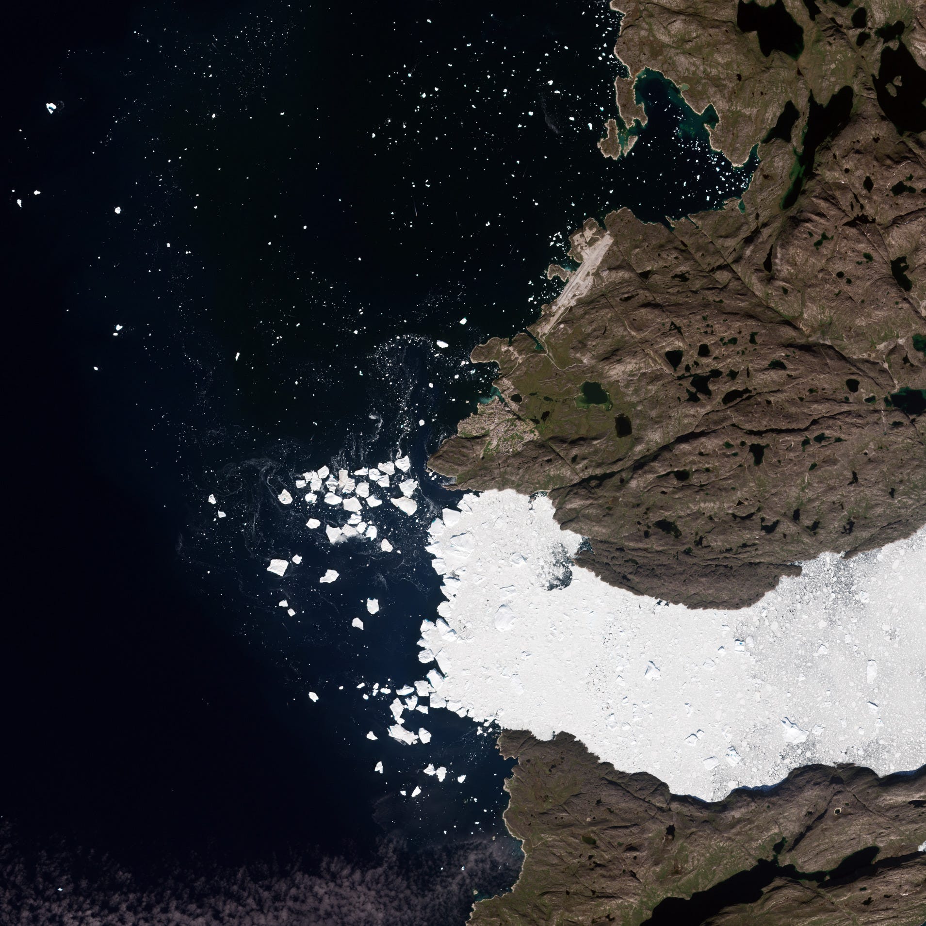
Earth from Space: Jakobshavn Glacier, Greenland [link]
"The Jakobshavn Glacier, known as Sermeq Kujalleq in Greenlandic, one of the fastest and most active glaciers in the world.
Jakobshavn Glacier drains approximately 6.5% of the Greenland ice sheet and produces around 10% of its icebergs. Many of these icebergs are so large that they become grounded in shallower areas of the fjord, where they remain for years until melting sufficiently to break apart and disperse."
Interesting reads
Why the Earth observation business model is flawed – and what must change [link]
Follow this opinion piece, written by Jarkko Antila, CEO of Kuva Space, about the Earth Observation business model and why it is flawed (and what must change).
Managing winter’s challenges with Copernicus Land [link]
"As winter approaches, the Northern Hemisphere faces growing challenges linked to climate change, with unpredictable snowfall patterns and shorter snow seasons impacting ecosystems, water resources, and industries. These shifts underscore the importance of tools like the Copernicus Land Monitoring Service (CLMS), which provides critical data on snow and ice coverage to support decision-making in hydropower generation, flood prevention, and ecological conservation.
This post explores how CLMS snow products are helping Europe adapt to a warming climate and manage the complex challenges of winter."
NASA-DOD Study: Saltwater to Widely Taint Coastal Groundwater by 2100 [link]
"Seawater will infiltrate underground freshwater supplies in about three of every four coastal areas around the world by the year 2100, according to a recent study led by researchers at NASA’s Jet Propulsion Laboratory in Southern California. In addition to making water in some coastal aquifers undrinkable and unusable for irrigation, these changes can harm ecosystems and corrode infrastructure."
Cutting-Edge Satellite Tracks Lake Water Levels in Ohio River Basin [link]
"The Ohio River Basin stretches from Pennsylvania to Illinois and contains a system of reservoirs, lakes, and rivers that drains an area almost as large as France. Researchers with the SWOT (Surface Water and Ocean Topography) mission, a collaboration between NASA and the French space agency CNES (Centre National d’Études Spatiales), now have a new tool for measuring water levels not only in this area, which is home to more than 25 million people, but in other watersheds around the world as well."
China's Remote Sensing [link]
"This report, prepared for the Commission by OTH Intelligence Group LLC, details China’s rapid development of mature remote sensing capabilities in pursuit of its economic and societal development, national security and geopolitical interests, and military modernization. Remote sensing is transforming a wide range of industries, scientific research, civil-government activities, and defense activities by providing a systematic means of collecting and processing data frequently from a bird’s eye view, which enhances understanding of what is happening on Earth."
The Case for ‘Space Mainstreaming [link]
"The Australian Centre for Space Governance published their seventh paper in their "Securing Australia Through Space" policy paper series: “The Case for ‘Space Mainstreaming’ to Advance National Priorities”.
This policy paper highlights how space technologies such as Earth observation (EO) can drive Australia’s economic, environmental, and national security goals. As outlined in the Intergenerational Report by the Commonwealth Treasury, major global forces—geopolitical risk, technological transformation, and climate change—require innovative responses where space capabilities play a critical role.
The paper introduces the concept of ‘Space Mainstreaming’, emphasising that space should be integrated across all levels of government policy—not confined to specialist agencies. This requires boosting space literacy and fostering interagency collaboration to maximise space’s potential for national benefit."
AI-driven rapid landslides mapping following the 2024 Hualien City Earthquake in Taiwan [link]
"On April 2nd, 2024, a Mw 7.4 earthquake struck Taiwan’s eastern coast, triggering numerous landslides and severely impacting infrastructure. To create the preliminary inventory of earthquake-induced landslides in Eastern Taiwan (3,300 km2) the authors deployed automated landslide detection methods by combining Earth Observation (EO) data with Artificial Intelligence (AI) models. The models allowed them to identify 7,090 landslide events covering >75 km2, in about 3 hours after the acquisition of the EO imagery. This research underscores AI’s role in enhancing landslide detection for disaster response and situational awareness, and its implications for understanding earthquake-landslide interactions to improve seismic hazard mitigation."
Declassified satellite photos reveal impacts of Vietnam War [link]
"By pinpointing bomb craters and swaths sprayed with herbicides, analysis could help direct remediation and cleanup efforts"
Satellites reveal stunningly detailed maps of Earth's seafloors [link]
"A new satellite has mapped Earth's ocean floors in unprecedented detail, a new study reveals. .
The first year of measurements from NASA's Surface Water and Ocean Topography (SWOT) satellite mission, launched in December 2022 and developed by NASA and France’s Centre National D’Etudes Spatiales, enabled researchers to study the boundaries between continents and identify underwater hills and volcanoes that are too small to be detected by earlier satellites."
Satellite-Based Earth Observation Market to grow by USD 7.6 Billion (2024-2028) [link]
"The global satellite-based earth observation market size is estimated to grow by USD 7.6 billion from 2024-2028, according to Technavio. Use of satellites for advanced environment monitoring is driving market growth, with a trend towards growing demand for small satellites."
2024 National Plan for Civil Earth Observation [link]
"The US National Science and Technology Council published the 2024 National Plan for Civil Earth Observations. The National Plan provides a vision for continued United States (U.S.) global role in enabling and leveraging civil EO to increase access to Earth data and address global changes.
In developing this National Plan, the U.S. Group on Earth Observations (USGEO) established three overarching principles that guide its approach and support the vision:
Improve the integration of Earth observing services across federal agencies and the broader Earth Observation Enterprise,
Ensure integrity and long-term quality of EO data across the EOE, and
Ensure the continued availability of foundational U.S. government capabilities in EO, while expanding the use of commercial data and services."
GHGSat and Carbon Mapper satellites take flight as landfill gas monitoring tech matures [link]
"Two groups have announced plans or launched new satellites in recent months that can map fugitive landfill gas. The technology is maturing at a critical time for emissions mitigation, as regulators consider tightening restrictions on landfills and deadlines loom for global methane reduction commitments.
Last month, GHGSat announced plans to launch nine satellites by the end of 2026, nearly doubling its existing fleet of 12. Carbon Mapper announced the launch of its Tanager-1 satellite in August, and it began reporting data from the satellite in November."
Detecting and quantifying greenhouse gas emissions [link]
"A new study from Carbon Mapper researchers analyzed detections from NASA's EMIT on-board the International Space Station — to determine its detection limit and help calculate the persistence, using observations of emissions from multiple instruments."
Interview with Kyle Barron on GeoArrow and GeoParquet, and the Future of Geospatial Data Analysis [link]
Follow this interview with Kyle Barron on GeoParquet and GeoArrow.
Podcasts
The AI revolution: how European weather services are harnessing innovation [link]
"Top representatives from leading European meteorological institutions have come together to discuss in a podcast how artificial intelligence (AI) is impacting the organisation of services and activities, highlighting the crucial role of European collaboration in driving this technological shift."
LinkedIn Highlights
10 Weird things I didn’t know about GIS [link]
Have a look at this list of realizations about working with GIS, by Lawrence X.
The future of satellite imagery exploitation: Using foundation models for highly tailored products [link]
Follow Joe Morrison's LinkedIn post on his take about the future of satellite imagery exploitation.
Don't skip the comment section!
Call for Abstracts
EGU 2025 [link]
"The EGU General Assembly 2025 brings together geoscientists from all over the world to one meeting covering all disciplines of the Earth, planetary, and space sciences. The EGU aims to provide a forum where scientists, especially early career researchers, can present their work and discuss their ideas with experts in all fields of geoscience."
Sessions:
ESSI1 – Next-Generation Analytics for Scientific Discovery: Data Science, Machine Learning, AI
ESSI2 – Data, Software and Computing Infrastructures across Earth and Space Sciences
ESSI3 – Open Science Informatics for Earth and Space Sciences
ESSI4 – Advanced Technologies and Informatics Enabling Transdisciplinary Science
ESSI5 – Open Session - Advances in Earth and Space Science Informatics
Deadline for abstracts: January 15, 2025
ESA-NASA Workshop on AI Foundation Models in Earth Observation [link]
"The workshop aims to explore how AI Foundation Models are transforming geospatial data analysis, EO downstream use cases, climate modelling, weather predictions, and beyond."
Deadline for abstracts: 31 January 2025 23:59 CET
Learning
Fire Data Academy [link]
"Learn how to use FIRMS fire detection data in python using Jupyter Notebook files."