

Level-2 News
Sentinel-1C captures first radar images [link]
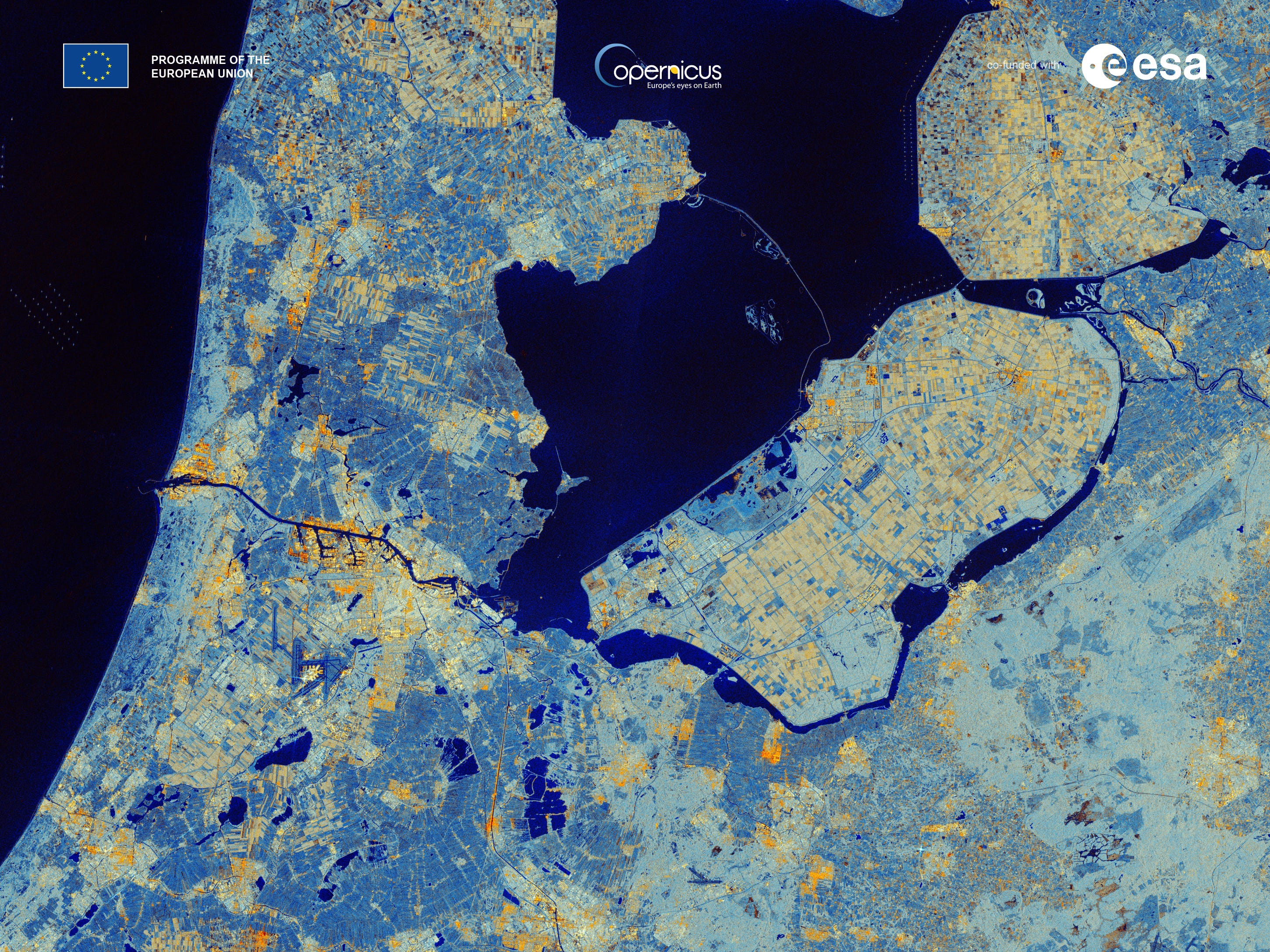
"Less than a week after its launch, the Copernicus Sentinel-1C satellite has delivered its first radar images of Earth – offering a glimpse into its capabilities for environmental monitoring. These initial images feature regions of interest, including Svalbard in Norway, the Netherlands, and Brussels, Belgium."
Related:
Waving goodbye to 2024 with another successful Copernicus Launch: Sentinel-1C now in orbit [link]
Pelican-2 & 36 SuperDoves Arrived in Vandenberg, California For Launch [link]
"Planet announced that its latest high-resolution satellite Pelican-2 and 36 SuperDoves have arrived at Vandenberg Space Force Base on December 9, in preparation for liftoff in early 2025 on board the Transporter-12 Rideshare mission with SpaceX. Pelican-2 joins Pelican-1 (a smallsat platform tech demonstration launched last year) as part of Planet’s next-generation, high-resolution fleet, to support and expand its existing SkySat capabilities.
Pelican-2 Is Equipped with the NVIDIA Jetson Platform and NASA CSP Satellite-to-Satellite Communications to Speed Data Delivery for Customers"
SynMax Expands Contract With Satellogic to Drive Company’s Oil and Natural Gas Production Monitoring Offering [link]
Satellogic announced an expansion of its contract with SynMax. SynMax will leverage Satellogic’s high-frequency, high-resolution imagery to enhance its Hyperion platform, delivering oil and natural gas production monitoring for hedge funds and financial analysts.
Under the contract, Satellogic will triple the number of wellheads monitored by SynMax across North America to more than 100, providing imagery multiple times per week.
constellr Signs Multi-Year Contract with the German Space Agency [link]
"constellr announced the signing of a multi-year contract with the German Space Agency (Deutsches Zentrum für Luft- und Raumfahrt, DLR).
The agreement will see constellr provide the German Space Agency’s community in Earth Observation research with access to its high-resolution thermal data at 30-meter native resolution.
The data will enable researchers to analyse crop health, understand urban heat islands, and study climate change impacts."
Space42 and ICEYE Announce Joint Venture to Bring Satellite Manufacturing to the UAE [link]
"Space42 and ICEYE, announced the creation of a joint venture to manufacture SAR satellites in the UAE, building on their successful cooperation, which includes the recent launch of the UAE's first SAR satellite, Foresight-1, in August 2024.
Space42’s new Assembly, Integration, and Testing (AIT) and LEO mission operations facilities in Abu Dhabi will be home to a local SAR ecosystem, hosting the joint venture’s manufacturing operations and Space42’s constellation operation services."
Wherobots raises $21.5m to advance geospatial and climate intelligence solutions [link]
"Cloud-based geospatial data platform Wherobots has raised $21.5m in a Series A funding round to enhance geospatial and climate intelligence solutions."
Planet Reports Financial Results for Third Quarter of Fiscal Year 2025 [link]
Planet announced financial results for the period ended October 31, 2024.
Record quarterly revenue of $61.3 million, an 11% YoY increase.
For the third quarter of fiscal 2025, the net loss was $20.1 million, down from $38.0 million in the same quarter of fiscal 2024.
The Adjusted EBITDA loss was reduced to $0.2 million, a sharp improvement from $12.0 million in Q3 FY 2024. Adjusted EBITDA is a key measure of operating performance, and the near-break-even result suggests they are very close to achieving operational profitability.
Pixxel Raises $24M For Hyperspectral Data Biz [link]
"Pixxel raised a $24M extension of its Series B funding round.
The Indo-US space data company is planning to launch six satellites with high-resolution hyperspectral sensors on the next SpaceX Transporter mission, expected in early 2025. Six more will follow on a subsequent SpaceX rideshare later in the year. Pixxel has been operating three demo satellites since 2022 to develop its technology."
Muon Space Wins SpaceWerx Contract for Space-Based Environmental Monitoring [link]
"Muon Space has received a SpaceWerx contract to advance space-based environmental monitoring capabilities. The award, announced Dec. 5, will support Muon Space’s development of a multi-mission, multispectral electro-optical/infrared (EO/IR) instrument. "
Big Ideas in Tech - Harnessing Earth Observation Data [link]
A VC firm, Andreessen Horowitz, featured the EO sector in their piece on looking towards 2025. They highlighted:
“The real commercial opportunity lies in developing verticalized products that use Earth observation as just one tool among many to address industry-specific needs.”
Developer's Orbit
SARvey - Open-source research software for InSAR time series analysis [link]
"SARvey is designed to make InSAR time series analysis accessible to a broader community. It runs on Linux, Mac, and Windows WSL, and the best part—it’s free and open-source!
To help you get started, the developers have put significant effort into the documentation and a demo dataset that makes the learning process easier."
Major TOM Embeddings Dataset [link]
"Major TOM Embeddings is the first open dataset of Copernicus embeddings providing dense and global coverage across the entire acquisition area of Sentinel-1 and Sentinel-2 sensors."
GenCast predicts weather and the risks of extreme conditions with state-of-the-art accuracy [link]
"In a paper published in Nature, Google Deepmind reasearchers presented GenCast, their new high resolution (0.25°) AI ensemble model. GenCast provides better forecasts of both day-to-day weather and extreme events than the top operational system, the European Centre for Medium-Range Weather Forecasts’ (ECMWF) ENS, up to 15 days in advance.
GenCast is part of Google’s growing suite of next-generation AI-based weather models, including Google DeepMind’s AI-based deterministic medium-range forecasts, and Google Research’s NeuralGCM, SEEDS, and floods models. These models are starting to power user experiences on Google Search and Maps, and improving the forecasting of precipitation, wildfires, flooding and extreme heat."
They’ll be releasing their model’s code, weights, and forecasts, to support the wider weather forecasting community.
Code on Github [link]
Data

Launch of the First Open-Source Brick Kiln Database Covering the Entire Indo-Gangetic Plain [link]
"APAD announced the expansion of their open-source brick kiln database to include India, Bangladesh, and Pakistan, comprehensively covering the Indo-Gangetic Plain (IGP). This region, one of the most polluted in the world, now has access to a resource that enables data-driven interventions for air quality management across borders.
This initiative has identified and mapped over 50,500+ brick kilns across the IGP, encompassing 1,106,675 square kilometers of densely populated and highly polluted terrain.
The database is freely accessible via their GitHub repository and can be visualized on their website.

An observational record of global gridded near surface air temperature change over land and ocean from 1781 [link]
"A new gridded data set of air temperature change across global land and ocean extending back to the 1780s. This data set, called the GloSAT reference analysis, has two novel features: it uses marine air temperature observations rather than the sea surface temperature measurements typically used by pre-existing data sets, and it extends further into the past than existing merged land and ocean instrumental temperature records which typically estimate temperature changes from the mid-to-late 19th century onwards."
Paper [link]

Snapshots
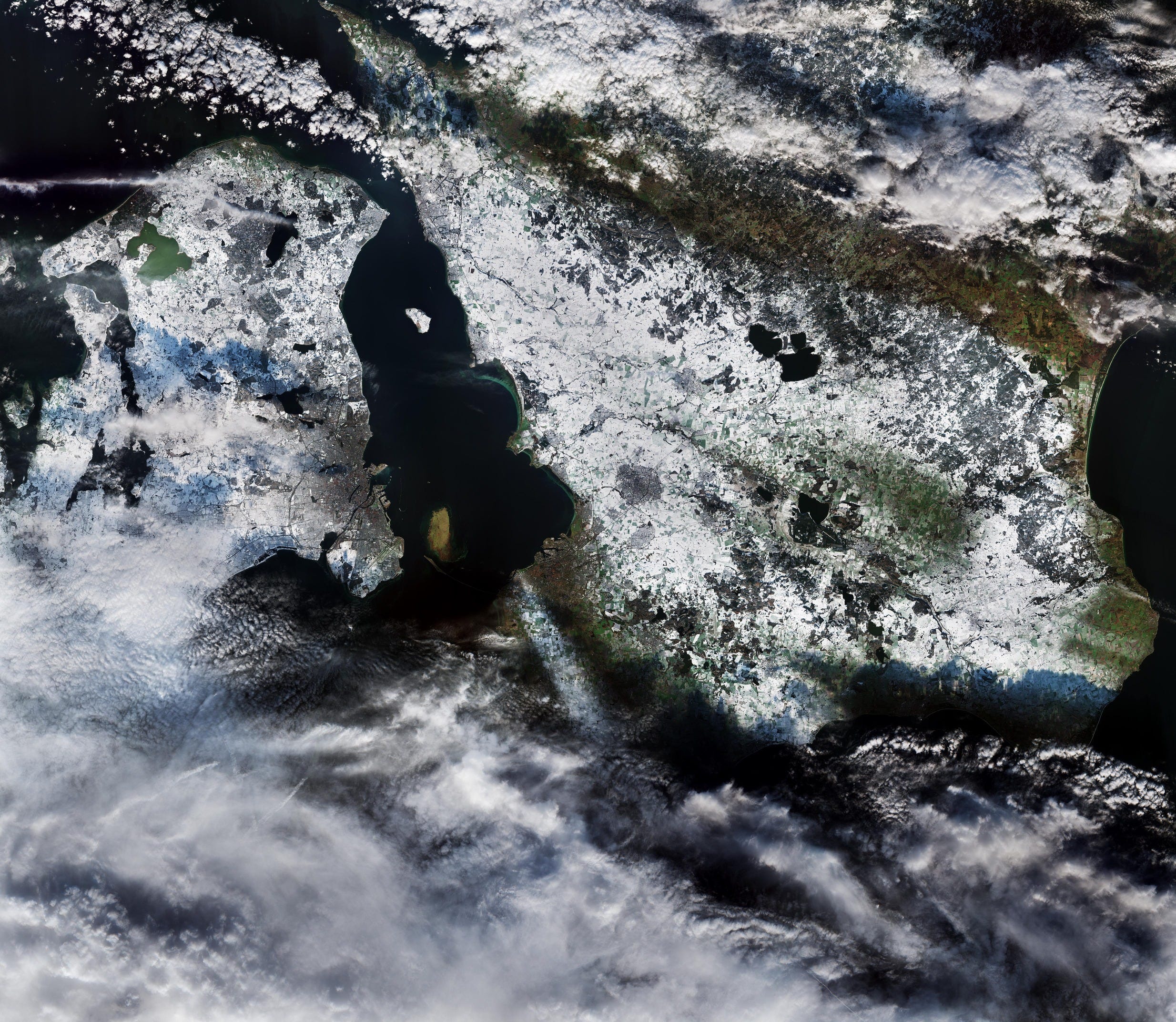
Earth from Space: First seasonal snow [link]
"The image highlights a white blanket of snow over most of Denmark (on the left) and southern Sweden (on the right), while patches of brown and green show areas that remained free of snow."
Wait...SAR can generate 3D data? [link]
"In this example, Umbra captured a site from multiple directions using multiple satellites in quick succession, and by combining complementary angles and high resolution spotlight images, you can derive a sub-meter terrain map in a matter of hours."
Interesting reads
Arctic Indigenous mapmakers are reclaiming the past, shaping their future [link]
"Building Indigenous GIS Capacity in the Arctic.
Due to dispossession and forced displacement caused by colonization, Indigenous People in the United States have lost nearly 99% of their land. While verbal and physical land acknowledgments aim to recognize this history of land theft and elevate the visibility of Indigenous Peoples as the land’s original and rightful inhabitants, another movement to decolonize place and space is gaining momentum: Indigenous mapmaking."
NASA’s PACE, US-European SWOT Satellites Offer Combined Look at Ocean [link]
"One Earth satellite can see plankton that photosynthesize. The other measures water surface height. Together, their data reveals how sea life and the ocean are intertwined."
NASA Flights Map Critical Minerals From Skies Above Western US [link]
"Technology used to chart other worlds is revealing minerals in the American West that are critical to the country’s renewable energy future."
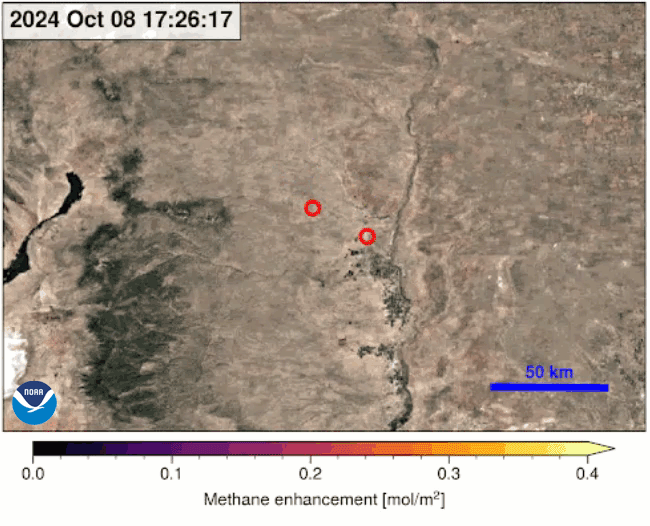
NOAA’s GOES Satellites Can Provide Quicker Detection of Large Methane Emissions [link]
Innovative use of NOAA’s geostationary satellites (GOES) has given scientists a new way to detect large methane emissions faster and more accurately. Results of a new experiment show the Advanced Baseline Imager (ABI), the highly advanced camera flying on the GOES-16, GOES-18 and the newly launched GOES-19 satellites, is able to pinpoint leaks or venting of methane—a potent greenhouse gas—as often as every seven seconds. NOAA scientists say the experimental verification of GOES methane data will lead to faster, more complete data on the location—and amount—of methane emissions and successful mitigation efforts, when there are accidental leaks.
For the experiment, NOAA scientists teamed up with experts from Harvard University and Carbon Mapper, a nonprofit organization, to examine the potential use and benefit of this feature for tracking and quantifying methane emissions.
Mark Rober's new satellite can take your selfie from space
"In January 2025, former NASA engineer Mark Rober, in partnership with CrunchLabs, T-Mobile, and Google Pixel, will launch SAT GUS, a satellite built to capture up to 1,000 selfies per day. All you need to do is upload your selfie, and they’ll take a picture of the phone attached to SAT GUS displaying your image with Earth in the background.
Muon Space contributed to this mission by supporting the thermal vacuum testing, as well as radiation testing at UC Davis." [link]
How Reuters counted the dead in famine-stricken Sudan [link]
"To examine mortality in Sudan’s famine-stricken Zamzam camp for internally displaced persons, Reuters turned to data gathered from space.
Commercial satellites can now identify objects as small as a few dozen centimeters wide. That makes it possible to recognize and count burial mounds in Darfur graveyards — and analyze change over time.
Journalists compiled a time series of very-high-resolution optical imagery from commercial providers Airbus, Maxar and Planet Labs.
Umbra Space also provided Reuters data from synthetic aperture radar (SAR) satellites"
Slooh launches new satellite-based Earth science curriculum for grades 5-9 emphasizing real-world STEM learning [link]
"Slooh, known for its live online telescope feeds and standards-aligned learning tools, has announced a new Earth science curriculum targeting US students grades 5-9.
The program incorporates satellite data to explore key concepts in geology, geography, and environmental science while introducing students to careers in the space and IT industries."