

Tune in to watch the launch of the Sentinel-1C satellite
"The earliest targeted launch date is planned for Thursday 5 December 2024 at 22:20 CET.
Tune in to ESA WebTV on 5 December from 22:00 CET to watch the satellite soar into space on a Vega-C rocket to be launched from Europe’s Spaceport in Kourou, French Guiana." [link]
"Radar allows us to see through what would otherwise be invisible. By sending out radio waves that bounce off objects and return as echoes, radar creates a detailed picture of our surrounding world.
This technology is everywhere: from guiding air traffic and enabling self-driving cars to tracking the movements of athletes. But its reach doesn’t stop there—radar is also transforming how we observe our Earth from space.
Satellites like the Copernicus Sentinel-1 mission use radar to see through clouds, darkness and any weather conditions. This capability is invaluable for detecting subtle changes on Earth’s surface—changes that are often hidden from the human eye. Discover how radar technology is helping us unlock these hidden insights about our planet."
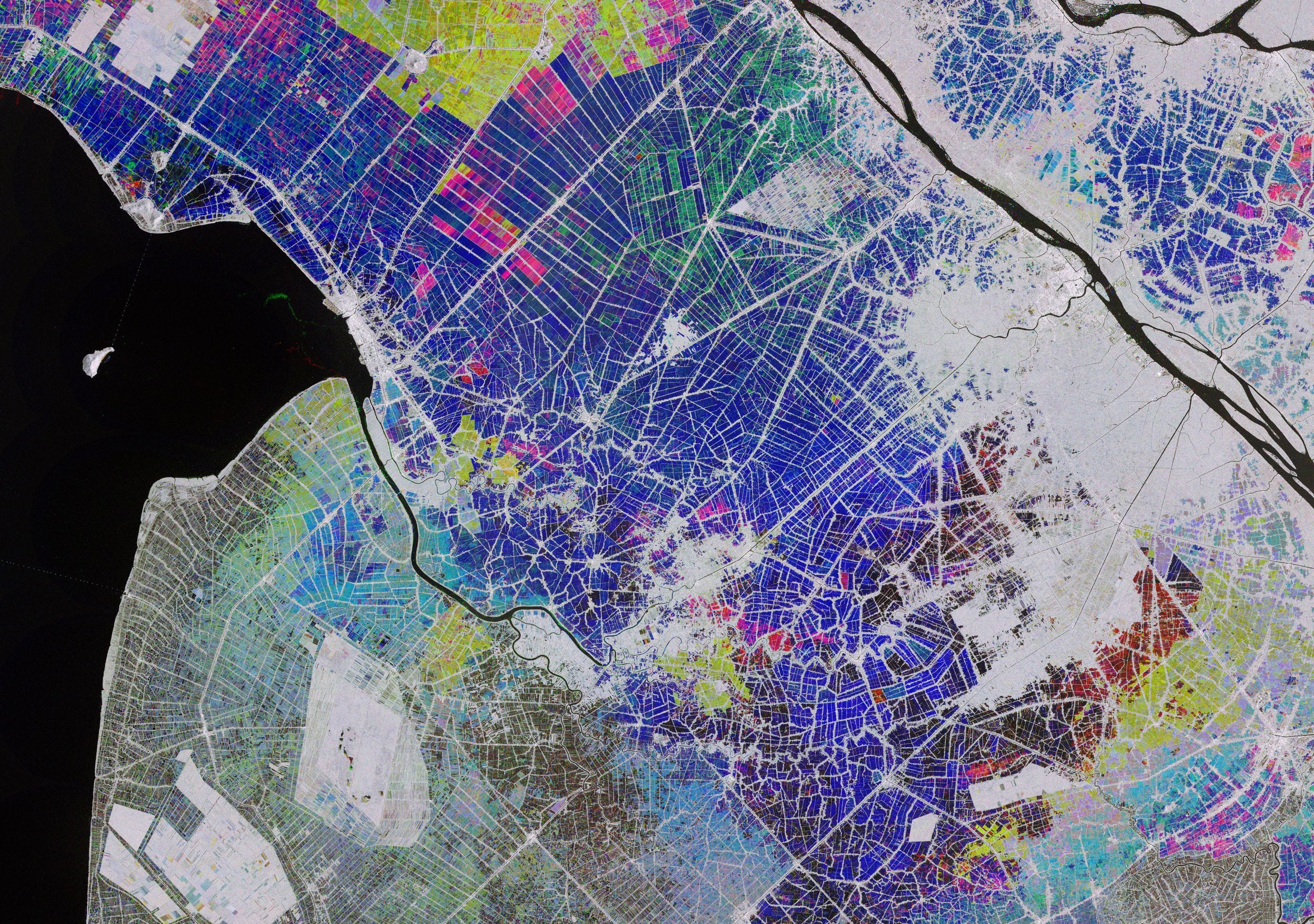
10 ways Sentinel-1 data lets us ‘see’ our world [link]
"As the launch of the Sentinel-1C satellite approaches, we reflect on some of the many ways the Copernicus Sentinel-1 mission has given us remarkable radar insights into our planet over the years."
Level-2 News
Europe’s most advanced weather satellite is now fully operational [link]
"The first of EUMETSAT’s Meteosat Third Generation (MTG) satellites became fully operational.
MTG-Imager 1 also receives a new name – Meteosat-12 – to mark the occasion.
The two main instruments on board Meteosat-12, the Flexible Combined Imager (FCI) and the Lightning Imager (LI), play a crucial role in enabling meteorological services to help protect lives and livelihoods by providing high-resolution, accurate data for predicting severe weather events."
Umbra Selected for NRO Strategic Commercial Enhancements Stage III, Strengthening U.S. SAR Capabilities [link]
"Umbra has been awarded the Stage III option of the National Reconnaissance Office’s (NRO) Commercial Radar Capabilities contract."
SatVu Secures £10M in Funding for its Thermal Imaging Service [link]
"SatVu has announced that it has secured £10 million (€12 million) in new funding to accelerate the deployment of the company’s HotSat-2 and HotSat-3 satellites."
GHGSat to Launch 9 More Satellites Before 2027 [link]
"GHGSAT is set to expand its satellite constellation with nine additional launches by 2027, increasing its fleet to 21 satellites. This growth will enhance their ability to monitor methane emissions globally, providing critical data to combat climate change."
Neo Space Group to acquire UP42 Earth Observation Digital Platform from Airbus [link]
"Neo Space Group (NSG), a Public Investment Fund-owned company and Saudi Arabia's leading commercial space services provider, has announced today that the company has entered into a definitive agreement with Airbus Defence and Space (Airbus) to acquire its UP42 business"
Princeton Infrared Technologies Awarded NASA SBIR Contract to Develop Next-Generation 24-bit SWIR Imager [link]
"Princeton Infrared Technologies announced that it has been selected by NASA for a Phase I SBIR contract to develop an advanced shortwave infrared (SWIR) imager. This innovative imager features a 640x512 resolution array with detection from 400 to 3000nm and an unprecedented 24-bit linear high dynamic range (HDR), establishing a new standard in infrared imaging."
Developer's Orbit
Earth Engine Task Manager - Running a GEE script directly in VS Code [link]
Check out this VS Code extension, developed by Oliver Lopez for monitoring and submitting Earth Engine tasks.
Smaller Satellite Images [link]
Follow this post by Mark Litwintschik where he explores WebP compression on a SkySat image.
Spoiler: He managed to compress the image down to 30 MB from its original 877 MB.
GeoParquet Downloader - QGIS plugin [link]
"This plugin connects to cloud-based GeoParquet data and downloads the portion in the current viewport.
It comes with pre-configured sources for Overture Maps, Source Cooperative"
Flexth: the open source tool to estimate the depth and extent of floods [link]
"Flexth is an innovative open-source tool developed by the European Commission's Joint Research Centre (JRC) to estimate water depth and improve flood mapping, particularly for satellite-derived maps, by incorporating terrain topography."
Code Repo [link]
Using NASA EarthData Cloud & Python to Model Climate Risks | PyData NYC 2024 [link]
"The goal of this tutorial is to give you hands-on experience accessing & using NASA Earthdata Cloud."
Data
Announcement of Opportunity for HotSat-1 [link]
"ESA is launching an Announcement of Opportunity for the international scientific community to access SatVu’s HotSat-1 archive data for science and EO-based applications development."
EUMETSAT Data Access Client 3.0 is now available [link]
"This latest release of the EUMETSAT Data Access Client (EUMDAC) improves download speed by splitting products in parts and downloading them in parallel.
The EUMETSAT Data Access API Client (EUMDAC) simplifies the way users can discover, search, download, and customise data contained in the EUMETSAT Data Store. It is available in two types of data access client, a Python library and a Command Line Interface (CLI) executable."

Snapshots
Ordnance Survey #30DayMapChallenge map gallery [link]
Explore some of the maps created by people working at Ordnance Survey, as part of the 30 Day Map Challenge.
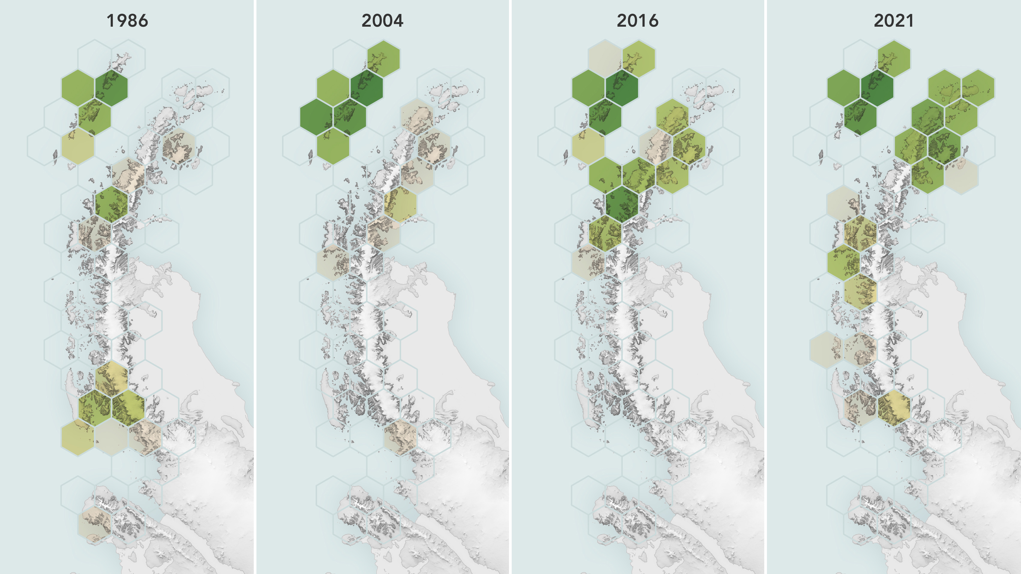
Satellites Reveal a Greener Antarctic Peninsula [link]
"The white, monochromatic vistas of Antarctica, a continent practically synonymous with ice, are becoming more verdant—at least around some of its edges. According to an analysis of 35 years of observations from Landsat satellites, the amount of vegetated land on the Antarctic Peninsula has increased more than tenfold since 1986.
As glaciers shrink and temperatures warm, plant life is finding more opportunity to move into this and other cold-climate regions. The expansion of greenery on the Antarctic Peninsula may signal a shift in its ecology, researchers say, raising questions about its future."
Climate

Space for Shore: Sentinel-1 reveals Arctic glacier retreat [link]
"As Arctic temperatures rise, marine-terminating glaciers—especially in places like Svalbard—are undergoing rapid retreat and intensified calving.
The ESA-funded Space for Shore project utilises radar data from the Copernicus Sentinel-1 mission to provide precise, year-over-year insights into glacier retreat and calving intensity, particularly in areas like Kongsfjorden, where notable glaciers are experiencing significant retreat.
Through a recent phase of the Space for Shore project—a collaboration between I-SEA (France) and NORCE (Norway)—scientists have utilised over a thousand image acquisitions from the Sentinel-1 mission to monitor the evolution of Svalbard's coastal glaciers in detail.
By analysing Sentinel-1 data from 2015 to 2023, the team has mapped glacier front lines and measured calving activity across Svalbard’s summer months, when calving intensities are at their highest."
Interesting reads
The State of AI in EO [link]
Read this article by Bruno Sanchez-Andrade Nuño. A thought-provoking and well-argued take on how AI can transform Earth Observation.
Follow the discussion in the comment section.
Taking to the skies for EarthCARE [link]
"Launched just six months ago and still in its commissioning phase, ESA’s EarthCARE satellite is already producing remarkable data from its four instruments, offering groundbreaking insights into clouds, aerosols, and Earth’s energy balance.
Highlighting the importance to Earth system science and climate research, teams worldwide are out in force taking measurements to verify and enhance the accuracy of EarthCARE’s data."
Related:
Mark Drinkwater's LinkedIn post highlighting the complexity of these cal/val campaigns [link]
A pan-European analysis of coastal subsidence with EGMS [link]
"Land subsidence increases the risk of flooding in low-lying coastal zones by amplifying relative sea-level rise (SLR). In this study, Dr. Rémi Thiéblemont and his team at the French Geological Survey (BRGM), assessed for the first time current coastal land subsidence at the scale of Europe using the new Copernicus European Ground Motion Service (EGMS) that was released in 2022. Their results suggest that nearly half of the low-lying coastal areas in Europe are currently subsiding at a rate faster than 1 mm/yr on average."
Paper:
Assessing Current Coastal Subsidence at Continental Scale: Insights From Europe Using the European Ground Motion Service [link]
Expanded AI Model with Global Data Enhances Earth Science Applications [link]
"NASA, IBM, and Forschungszentrum Jülich have released an expanded version of the open-source Prithvi Geospatial artificial intelligence (AI) foundation model to support a broader range of geographical applications. Now, with the inclusion of global data, the foundation model can support tracking changes in land use, monitoring disasters, and predicting crop yields worldwide."
LinkedIn Highlights
Reactions following the acquisition of UP42 by Neo Space Group
Follow this post by Daniel Seidel, co-founder of LiveEO, hightlighting that the acquisition weakens Europe's data souvereignty. [link]
Check out Aravind's post, commenting that the EO platform/marketplace segment has had the most "exits" in EO. [link]
Finally, don’t skip Leo Wang's post where he tries to figure out what this means from a product and sales strategy standpoint for UP42's marketplace. [link]
Joe Morrison's post on export laws on SAR satellites [link]
Follow Joe Morrison's post on how export laws in the U.S. affect the SAR industry.
Learning
Spatial Data Management [link]
Material available from the Spatial Data Management course (GEOG-414), tought by Qiusheng Wu in Fall 2023 at the University of Tennessee, Knoxville.
I just heard about IBM's Prithvi geospatial foundational model in a GeoAwesome webinar today, but I don't really understand how it can be so multipurpose and what it would take to tune it to your application/study area....