100 Spectral Reflectance Newsletter Issues!
Over two years ago, I published the very first issue of this newsletter. Today, I’m proud to say that it’s read by hundreds of people every week. Some of you read through the content and follow the links, while others use it as a quick way to stay updated on what's new and interesting in Earth Observation. A past colleague once called it a "one-stop-shop for all things EO" - I really liked that description!
Thank you all for your incredible support! Special thanks to those who’ve reached out over the last two years to share feedback or simply let me know you enjoy the newsletter. It truly means a lot. 💙🛰️
Here’s to the next 100 issues! 🚀🛰️🌍 If there’s something you’d love to see in future issues, feel free to reach out—I’d love to hear your thoughts!"
Level-2 News
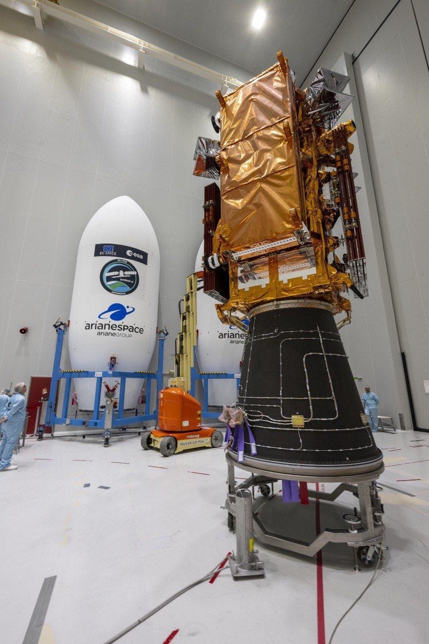
Sentinel-1C has been encapsulated inside the two halves of the Vega-C rocket fairing [link]
Launch is scheduled to take place on 3 December.
First Images from Maxar’s Third and Fourth WorldView Legion Satellites Showcase “Dawn-to-Dusk” Collection [link]
MAXAR released the first images from their third and fourth WorldView Legion satellites.
These two WorldView Legion satellites are Maxar’s first satellites in mid-inclination orbit (MIO), meaning they orbit around Earth’s mid-latitudes (+/- 45 degrees latitude), where 90% of the world’s population resides.
Satellites in MIO can collect images at different times of day, from sunup to sundown." (“Dawn-to-Dusk”)
Planet's 3-meter Forest Carbon Monitoring dataset is now available in Upstream Tech's Lens platform [link]
"This dataset offers organizations enhanced granularity, with updates every quarter giving insight on canopy height, canopy cover, and aboveground carbon. For Lens users, this means precise data and powerful tools to support monitoring, reporting, and verification for climate action and forest conservation goals."
Planet to Announce Fiscal Third Quarter 2025 Results on Monday, December 9, 2024 [link]
"Planet announced that it plans to release its fiscal third quarter 2025 financial results for the quarter that ended October 31, 2024, after market close on Monday, December 9, 2024."
Planet and Global Fishing Watch Expand Collaboration for Ocean Transparency and Accountability [link]
"Planet announced a new contract with Global Fishing Watch, an international nonprofit dedicated to advancing ocean governance through increased transparency of human activity at sea. The 6-figure deal is an expansion of the organization’s ongoing agreement with Planet, and will allow Global Fishing Watch to fully leverage PlanetScope data and Machine Learning (ML) to improve ocean stewardship and foster greater compliance and accountability across all maritime sectors."
Spire’s data assimilation breakthrough enhances weather forecast accuracy with GNSS-R [link]
"In a significant achievement for the field of weather forecasting, Spire’s Data Assimilation (DA) team has reached a milestone by assimilating Global Navigation Satellite System Reflectometry (GNSS-R) data from NASA’s CYGNSS mission into numerical weather prediction models. CYGNSS is a constellation of microsatellites that measures ocean wind speeds, enhancing hurricane research and prediction. This data assimilation milestone is paving the way for using Spire’s operational constellation of GNSS-Reflectometry satellites for improved weather forecasts."
First Dutch Military EO Sat to Launch in 2027 [link]
"The Netherlands is preparing to boost both its domestic space industry and its national security capabilities in orbit with the launch of its first military EO sat, to be built by a consortium of Dutch companies."
Maxar prepares for final WorldView Legion launch to complete advanced imaging constellation [link]
"Maxar Intelligence is targeting early 2025 for the launch of its final pair of WorldView Legion imaging satellites, marking the completion of an ambitious six-spacecraft Earth observation constellation."
Teledyne Space Imaging partners with Satlantis on very high-resolution sensor [link]
"Teledyne Space Imaging is collaborating with Satlantis to develop key electronics for a sensor for Earth observation and planetary exploration.
Satlantis will develop Front-end Electronics (FEE) for Teledyne’s in-development CIS125 TDI detector.
The CIS125 Time Delay Integration (TDI) imaging sensor being developed by Teledyne Space Imaging features a 5 µm pixel size. When combined with super-resolution techniques, the sensor can achieve a resolution of less than 10 centimeters."
Lockheed Martin teams with Iceye to advance AI-enabled targeting [link]
"Defense contractor Lockheed Martin is partnering with a consortium led by Iceye, a Finnish Earth observation company specializing in radar imaging satellites, to develop AI-powered target recognition technologies for Finland’s military.
The initiative leverages Lockheed Martin’s automated target recognition (ATR) algorithms, which use artificial intelligence to analyze satellite imagery and identify objects or targets. The company will develop AI algorithms using Iceye’s synthetic aperture radar imagery."
Developer's Orbit
Improving GroupBy.map with Dask and Xarray [link]
"Running large-scale GroupBy-Map patterns with Xarray that are backed by Dask arrays is an essential part of a lot of typical geospatial workloads. Detrending is a very common operation where this pattern is needed.
In this post, Patrick Hoefler explores how and why this caused so many pitfalls for Xarray users in the past and how they improved performance and scalability with a few changes to how Dask subselects data."
Data
Foursquare Open Source Places: A new foundational dataset for the geospatial community [link]
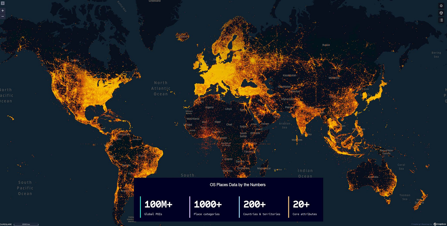
Earlier this week Foursquare dropped a massive dataset called Open Source Places, featuring over 100 million global Points of Interest (POIs), and it got the geospatial world buzzing. The dataset is free to use under an Apache 2.0 license, which means anyone can dive in for personal or commercial projects.
People have been quick to get creative—like Fused, who partitioned the data into GeoParquet files and made them available on Source Cooperative.
Not everything’s perfect, though. Some users have pointed out issues with the overall data quality and the lack of confidence scores, which would give users a better sense of the accuracy of each POI.
People are already looking into cleaning up the dataset, upgrading it to the newer GeoParquet 1.1 standard, and exploring how it could work alongside Overture Places. (For more, follow the comment section here)
Funny highlight: Jed Sundwall's LinkedIn post showing how he acquired the data [link]
Japanese Farmland Parcel Polygons [link]
Agricultural field polygon data from the Japanese government is now available through Source Cooperative.
"Japanese Farmland Parcel Polygons (Fude Polygons in Japanese) represent parcel information of farmland. The polygons are manually digitized data derived from aerial imagery, such as satellite images. Since no on-site verification or similar procedures have been conducted, the data may not necessarily match the actual current conditions. Fude Polygons are created for the purpose of roughly indicating the locations of farmland."
The dataset on Source Cooperative [link]

Snapshots

Daniel Coe’s Astonishing River Cartography [link]
"Cartographer Daniel Coe uses relative elevation data, primarily from plane-mounted lasers called lidar, to visualize Earth’s natural features, like rivers and floodplains. His stunning river maps reveal stories hidden in historical sediment and past channels carved by the water, as it twists and turns through both landscape and time."
You can find more of his work here and on his flickr account.

Extratropical Cyclone Whips Over the Pacific Northwest [link]
"A strong extratropical cyclone hit the Pacific Northwest on November 19, 2024, bringing damaging winds and rain to the region. The storm knocked over trees and left nearly 600,000 people without power in Washington state on November 20, according to news reports.
Extra-tropical cyclones are large rotating weather systems that occur in the midlatitudes (generally more than 30° latitude away from the equator). Mature extratropical cyclones like this often feature comma-shaped cloud patterns that are the product of “conveyor belt” circulation. Heavy precipitation is often present near the low-pressure head of the comma."
Climate
How will climate change in your region? [link]
"The C3S Atlas allows you to explore and analyse past and future climate monitoring and change information in a flexible way.
It facilitates global and regional in-depth assessment of past trends and future changes in key variables and (extreme) indices for different periods across emission scenarios or for different policy-relevant global warming levels (e.g. 1.5°, 2°, 3° and 4°)."
Related:
Copernicus Interactive Climate Atlas [link]
The Copernicus Interactive Climate Atlas: a tool to explore regional climate change [link]
Interesting reads
Study shows natural regrowth of tropical forests has immense potential to address environmental concerns [link]
"A new study in Nature finds that up to 215 million hectares of land (an area larger than Mexico) in humid tropical regions around the world has the potential to naturally regrow. That much forest could store 23.4 gigatons of carbon over 30 years and also significantly help enhance biodiversity and water quality. The study showed that more than half of the area with strong potential for regrowth was in five countries: Brazil, Mexico, Indonesia, China, and Colombia.
The authors used satellite images to identify millions of small areas where tree cover increased over time. They then excluded the areas planted by humans with machine learning, focusing on natural regrowth."
Paper: Global potential for natural regeneration in deforested tropical regions [link]
Podcasts
How Open Science and AI Are Advancing Hurricane Research [link]
"As climate change drives more frequent and intense tropical cyclones and hurricanes, coastal communities desperately need better tools to predict how bad storms will be and when and where they’ll strike—and to assess the damage afterward. From the air and in space, NASA and NOAA collect critical data as storms roll in. But what happens next? Fly directly into the eye of the storm with daring hurricane hunter pilots, meet meteorologists and data scientists building AI models to improve hurricane prediction, and join the disaster response experts helping cities pinpoint their hardest-hit neighborhoods. Plus, learn how NASA is making data open to everyone—including you, with Transform to Open Science."
LinkedIn Highlights
Playing GeoGuessr with an LLM: can Llama 3.2 recognize a city from aerial imagery? [link]
Check out Dominik Weckmüller's post on LinkedIn where he played GeoGuessr with an LLM; "Dominik presented Llama 3.2 11B with a detailed aerial image (40cm DOP) of a European city, and it analyzed urban patterns and architecture to make educated guesses."

On November 14th, a SAS flight from Stockholm to Miami was forced to make an unexpected diversion, landing in Copenhagen. What exactly happened? [link]
Follow Guido Cioni's post on LinkedIn as he offers his analysis of the incident, using ECMWF clear-air turbulence (CAT) forecast data.


