

Level-2 News
India launches satellite for ocean monitoring [link]
On Saturday, India launched EOS-06, formerly known as Oceansat 3.
EOS-06 is designed to take measurements of ocean color, ocean winds, and sea surface temperatures. It carries an imaging system, called the ocean color monitor that covers 13 visible and NIR channels, a thermal infrared instrument and a scatterometer. EOS-06 has a resolution of 360 meters and 2-day global coverage. Among other use-cases, the data products will be used to track tropical cyclones, detect algal blooms, track water pollution, fish populations and sediment distribution.
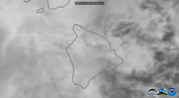
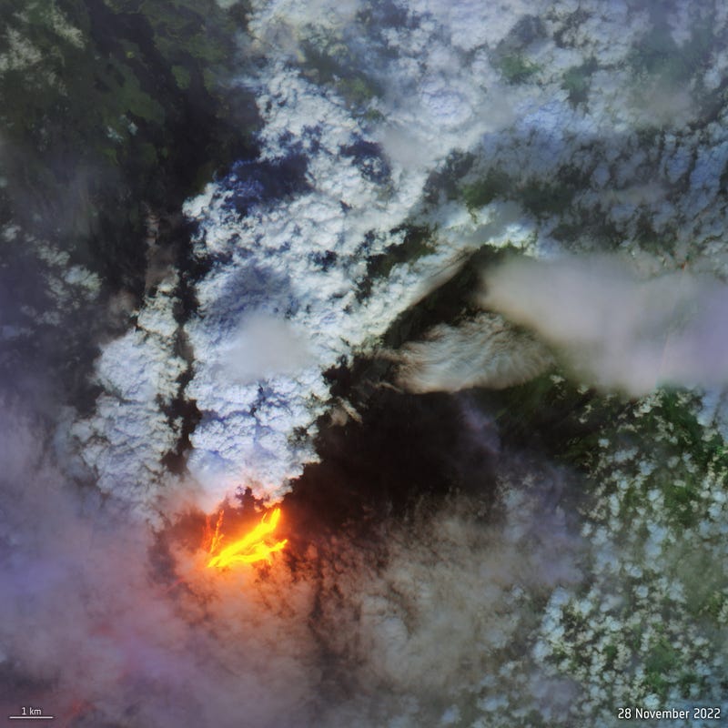
Satellites watch Mauna Loa, world’s largest active volcano, erupt in Hawaii [link]
“Hawaii’s Mauna Loa erupted on Sunday (Nov. 27), releasing a large plume of ash and toxic gasses along with multiple lava flows.”
Follow the USGS’s dedicated webpage for updates and photos.
More info and satellite coverage:
Mauna Loa Awakens [NASA Earth Observatory]
Mauna Loa Eruption [RAMMB-CIRA Satellite Library]
CAMS monitors SO2 as Mauna Loa volcano awakens for the first time in 40 years [Copernicus Atmosphere Monitoring Service]
Sulphur Dioxide forecasts [Copernicus Atmosphere Monitoring Service]
Hawaii’s Mauna Loa erupts for the first time in 38 years. What happens next? [link]
Competitions
NASA Harvest Field Boundary Detection Challenge Webinar [link]
Since posted in the last newsletter, hosts have set up a webinar about the challenge.
Developer’s Orbit
HISTARFM — How to Work with Gap-Filled Imagery [link]
Follow this Earth Engine Tutorial to learn how to use the HIghly Scalable Temporal Adaptive Reflectance Fusion Model (HISTARFM) data.
“The HISTARFM database is a gap-filled monthly reflectance temporal series at 30m spatial resolution generated by the fusion of Landsat and Moderate Resolution Imaging Spectroradiometer (MODIS) temporal series.”
Datasets
KappaSet: Sentinel-2 KappaZeta Cloud and Cloud Shadow Masks [link]
“The dataset consists of 9251 labelled 512x512 pixel sub-tiles from 1038 Sentinel-2 (S2) Level-1C (L1C) products at 10m resolution distributed over the globe.”
They have also published their model (DeepLabv3Plus), trained on KappaSet. You can find it here.
Interesting reads
SMOS data improve estimates of rainfall in Africa [link]
“data from SMOS was used as an alternative to rain gauge measurements”

Satellite Images Mitigate Flood Impacts: Interview with Cloud to Street CEO Bessie Schwarz [link]
Read the interview to learn how Cloud to Street provides flood data related flood risk evaluation, early detection and near real-time tracking, and insurance purposes.
Upcoming workshop
Webinar: An Introduction to NASA’s Socioeconomic Data and Applications Center Datasets for Health and Air Quality Impacts [link]
Date: 30 November , 2022
JuliaEO 2023 — Global Workshop on Earth Observation with Julia [link]
“This will be a hybrid workshop aiming to develop the computer programming skills of those working in Earth Observation.
The topics covered include acquisition, processing, visualisation, and classification of Earth Observation data, using the Julia programming language.”
Dates: 9–13 January 2023
Online participation is free and unlimited (Registration required)