

Level-2 News
Maxar secures dedicated access to Umbra’s SAR constellation [link]
Maxar has signed a contract with satellite imagery startup Umbra to get dedicated access to the company’s SAR constellation, allowing Maxar to directly task Umbra’s satellites and integrate SAR data into Maxar’s Rapid Access Program (RAP) platform.
Sentinel-4 set to join next weather satellite [link]
“Copernicus Sentinel-4, which is set to play a key role in monitoring air quality over Europe, is ready to be fitted to its host, the first Meteosat Third Generation Sounder weather satellite.”
The ESA Green Transition Information Factory (GTIF) is released in beta version. [link]
At the moment, the first GTIF demonstrator for Austria is available in the platform.
GTIF functionality will be gradually expanded to cover other countries and eventually all of Europe, accelerating the continents transition to more sustainable future.
EO Browser joins Copernicus Data Space Ecosystem — meet the Copernicus Browser [link]
A new, more intuitive browser interface, which is based on Sentinel Hub’s EO Browser open-source code to search, visualize and download products from the Copernicus Data Space Ecosystem.
Harvard researchers provide policymakers a clearer picture on methane emissions [link]
“Funded by the Harvard Climate Change Solutions Fund, which was started by the University in 2014 to support research and policy initiatives battling climate change, the project is using observations from recently deployed satellites to create a clearer picture of precisely where and how methane is being emitted.”
Radiant Earth Foundation 2022 Annual Report [link]
Radiant Earth Foundation released their 2022 Annual Report, a comprehensive overview of their achievements; creating datasets, sharing trained models and supporting the development of tools in the STAC ecosystem!
Top trends in satellite imagery [link]
From data availability to improved spatial and temporal resolution, and from the role of ML to native architectures like COG and STAC, Bill Morris — Geospatial Software Engineer at Mapbox — shares the trends he has identified.
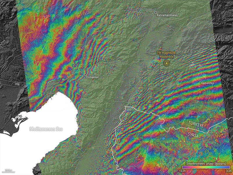
Satellites support impact assessment after Türkiye–Syria earthquakes [link]
“Türkiye and Syria are reeling from one of the worst earthquakes to strike the region in almost a century. Tens of thousands of people have been killed with many more injured in this tragedy.
Satellite data are being used to help emergency aid organisations, while scientists have begun to analyse ground movement — aiding risk assessments that authorities will use as they plan recovery and reconstruction, as well as long-term research to better model such events.”
Related:
Earthquake Damage in Türkiye [NASA Earth Observatory]
Land surface has been displaced by up to six metres [DLR]
DLR supports emergency responders in Turkey [link]
Earthquake in Türkiye; First impact study on Osmaniye City with Pléiades Neo image [link]
Developer’s Orbit
Configuring a Minimal Docker Image for Spatial Analysis with Python [link]
Maurício Cordeiro put together a tutorial on how to install the basic geospatial dependencies, such as GDAL and XArray, and deploy them as a docker container.
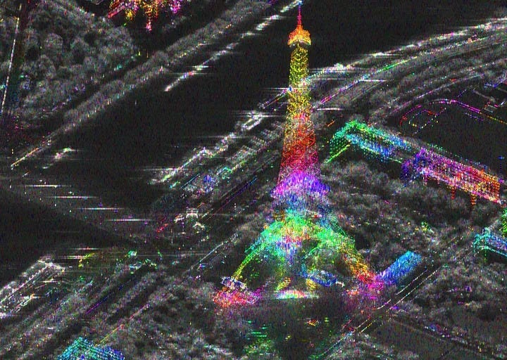
“Serving tip” for a radar interferogram [link]
Follow this medium story by Elise Colin to learn how to represent a complex interferometric coherence in colors using scipy and matplotlib.
Snapshots
Planet Snapshots Issue 62: Mines [link]
In this week’s issue:
The booms and busts of mining
Waterways impact local landscapes
A Dove peers over the Himalayas
Wildfires burn in Chile

Food: Citrus Growing in South Africa [link]
“South Africa is the world’s second largest citrus fruit exporter after Spain.
Today, the country’s citrus fruit farming industry is worth nearly 2 billion € and represents 37% of the country’s exports.
Over 1 million tons of oranges, 280,000 tons of lemons and 200,000 tons of mandarins and grapefruits are exported annually, mainly to Europe.”
Interesting reads
Weather Forecasters Adopt NASA’s ‘Occult’ Science; Radio occultation, pioneered by NASA for other planets, offers cheaper, better Earth weather data [link]
Due to grounded aircraft during the peak of the COVID-19 pandemic, weather agencies didn’t have access to data collected from atmospheric sensors installed onboard them. To fill this gap they ended up using method of atmospheric sounding that was pioneered and first used to gather data on the Martian atmosphere from the Mariner spacecraft in the 1960s.
Celebrating a decade Landsat 8 [link]
“Landsat 8 celebrates its tenth anniversary this week on Saturday, February 11, 2023. The technology of the satellite and its instruments, revolutionary in 2013, continues to provide important and timely data for scientific observation of the Earth’s land surfaces. Landsat 8 continues to image the Earth with Landsat 9 and Landsat 7.”
Upcoming Webinars
Use of EO data in search and rescue [link]
“Benjamin Kuo, will share his expertise on the various types of imagery data available, including commercial options from Airbus, Maxar, and Capella, as well as open Sentinel data. Participants will get a first-hand look at the pros, cons, and challenges of working with EO data, and hear inspiring examples of how satellite️ data has aided in successful search and rescue operations.”
27 February 2023
7th Advanced Training Course on Radar Polarimetry [link]
“The European Space Agency (ESA) is organising the 7th ESA Advanced Course on Radar Polarimetry for training the next generation of Earth Observation (EO) scientists in dual and fully polarimetric data for science and applications development.
The course is part of ESA’s EO Science for Society — the Scientific Exploitation element of EOEP-5 (the fifth cycle of ESA’s Earth Observation Envelope Programme) for pioneering new EO services and scientific discoveries, stimulating downstream industry growth, and supporting international responses to global societal challenges.”
Application submission closure: 15 March 2023
Pangeo Spring 2023 Showcase [link]
The Pangeo Showcase Webinar Series is back for its Spring cycle. Take a look at the webinars planned so far!
Learning
Landsat’s enduring legacy [link]
Read this free digital book to learn more about remote sensing and specifically the Landsat program. It is full of useful historic and up-to-date information and lists the challenges they faced and how they solved them!
Recordings from the ECMWF–ESA Workshop on Machine Learning for Earth Observation and Prediction are out! [link]
Thematic areas that were covered in the workshop include:
1. Machine Learning for Earth Observations
2. Hybrid Machine Learning — Data Assimilation
3. Machine Learning for Model emulation and Model discovery
4. Machine Learning for user-oriented Earth Science applications
5. Machine learning at the edge and high-performance computing